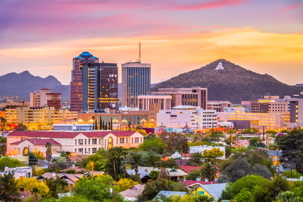
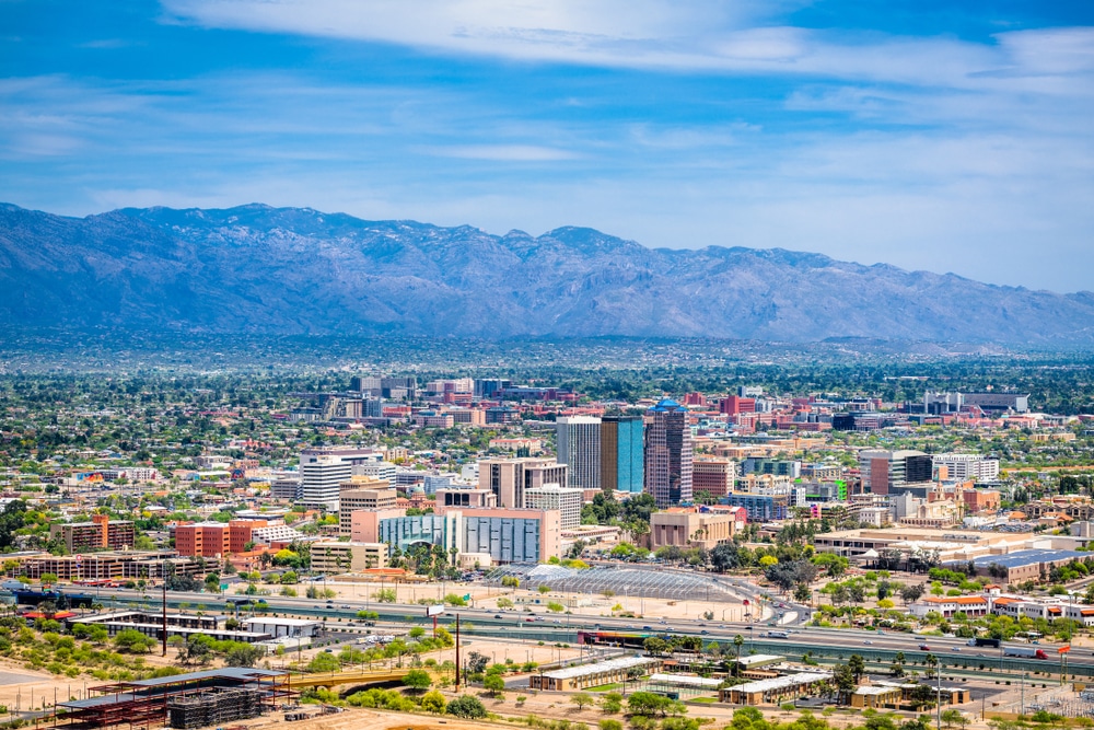
Nestled in the Sonoran Desert basin and embraced by five mountain ranges, Tucson stands as Arizona’s second-largest city yet maintains the warm, interconnected feel of a much smaller community. Located just 60 miles north of the U.S.-Mexico border, this desert oasis occupies a unique geographic and cultural crossroads that has shaped its distinctive character over thousands of years. Home to approximately 545,000 residents within the city limits and over one million in the greater metropolitan area, Tucson’s population reflects a rich tapestry of cultures—predominantly Hispanic/Latino (43%), non-Hispanic white (41%), with significant Native American, Black, and Asian communities contributing to its diversity.
What truly sets Tucson apart is its remarkable synthesis of seemingly contradictory qualities: it’s a modern university town that reverently preserves ancient traditions; a desert community that celebrates water and lush growth; a borderland that embodies both American and Mexican influences without diminishing either. In Tucson, centuries-old adobe walls stand alongside cutting-edge aerospace facilities, and Indigenous ceremonies continue in the shadows of contemporary urban life. This is a place where the past is not merely remembered but actively lived, creating a community unlike any other in the American Southwest.
Today, this layered history is preserved and celebrated through institutions like the Arizona Historical Society, the Presidio San Agustín del Tucson Museum, and Tucson’s lovingly restored historical neighborhoods such as El Presidio, Armory Park, and Barrio Viejo. Each year, the Tucson Presidio Trust hosts Living History Days where residents and visitors experience the sights, sounds, and activities of 18th-century Tucson, ensuring that the community’s foundational stories remain alive for future generations.
The story of human habitation in the Tucson Basin begins nearly 12,000 years ago, with archaeological evidence of Paleo-Indian and Archaic peoples who hunted and gathered in this desert environment. Around 300 BCE, the Hohokam culture established permanent settlements, developing sophisticated irrigation systems that transformed the arid landscape. The Tohono O’odham (historically called Papago) and the Pascua Yaqui tribes are the direct descendants of these early inhabitants, and both maintain sovereign tribal lands within and adjacent to modern Tucson.
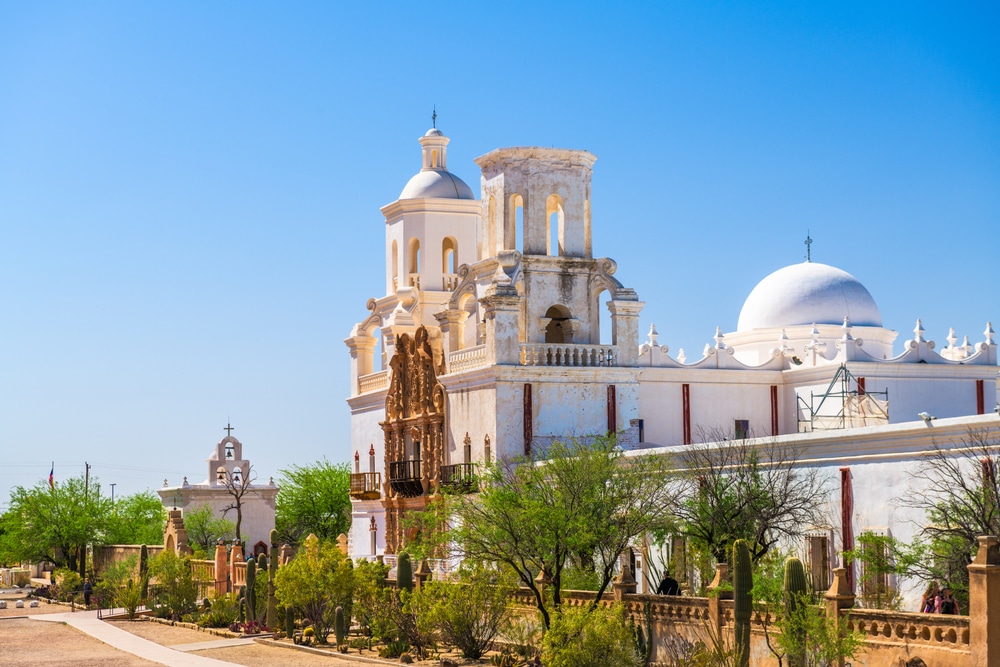
Spanish missionaries arrived in the late 17th century, with Father Eusebio Kino establishing missions throughout the Pimería Alta, including the stunning Mission San Xavier del Bac—the “White Dove of the Desert”—which continues to serve the Tohono O’odham community today. In 1775, the Spanish built the Presidio San Agustín del Tucson, establishing the foundation of the modern city. Tucson’s name itself derives from the O’odham word “Chuk-son,” meaning “black base,” referring to the volcanic mountains west of the city.
After Mexican independence in 1821, Tucson became part of Mexico until the 1854 Gadsden Purchase transferred the region to the United States. The city served as the territorial capital from 1867 to 1877 and weathered the turbulent Apache Wars era before Arizona achieved statehood in 1912. Through the 20th century, Tucson transformed from a ranching and mining hub to a center for aerospace, optics, and tourism.
| Category | Details |
|---|---|
| Location | Southern Arizona, Pima County |
| Founded | Officially established in 1775 by Spanish settlers |
| Incorporated | 1877 |
| Population | Approx. 545,000 (City), over 1 million (Metro Area, 2020 Census) |
| Elevation | ~2,389 feet (728 meters) |
| Climate | Hot desert climate (low humidity, very hot summers, mild winters) |
| Known For | University of Arizona, Sonoran Desert, cultural diversity, astronomy |
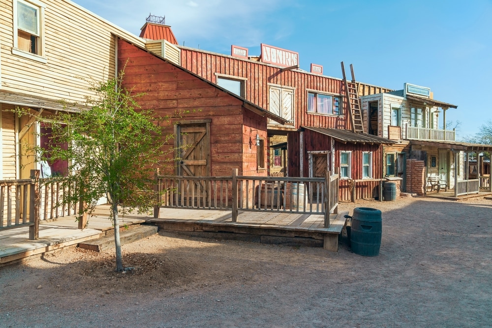
| Major Attractions | Saguaro National Park, Arizona-Sonora Desert Museum, Old Tucson Studios, Pima Air & Space Museum |
| Key Industries | Aerospace & defense, optics, education, healthcare, tourism |
| Major Institutions | University of Arizona, Davis-Monthan Air Force Base |
| Annual Events | Tucson Gem & Mineral Show, All Souls Procession, Tucson Rodeo (La Fiesta de los Vaqueros) |
| Transportation | Tucson International Airport (TUS), Interstate 10, Sun Link Streetcar |
| Education | Public (TUSD), charter, private schools; major universities and colleges |
| Nearby Natural Sites | Catalina Mountains, Mount Lemmon, Sabino Canyon |
| Cultural Significance | UNESCO City of Gastronomy (2015); rich Native American, Spanish, and Mexican heritage |
Tucson’s cultural identity emerges from the intertwining of Native American, Hispanic, and Anglo traditions, creating what locals proudly refer to as “The Blend”—a uniquely Sonoran borderlands culture. Unlike many Southwestern cities where these cultural traditions developed in separate enclaves, Tucson’s geography and history fostered greater integration and cross-cultural exchange.
The Tohono O’odham and Pascua Yaqui tribes maintain vibrant cultural traditions that have influenced everything from Tucson’s cuisine to its approach to desert living. Their seasonal celebrations, particularly the Pascua Yaqui Easter ceremonies and the Tohono O’odham Saguaro Harvest (Ha:san Bak), continue to be practiced in ways that connect ancient wisdom with contemporary life.
Hispanic heritage permeates daily life in Tucson, with Spanish remaining a living language throughout the community. Mexican culinary traditions, musical styles like mariachi and norteño, and artistic expressions such as the region’s distinctive folk arts have deeply shaped Tucson’s identity. The annual Tucson International Mariachi Conference brings musicians and dancers from across the Americas to celebrate and preserve these traditions.
Anglo settlers brought their own cultural elements, from ranching traditions to architectural styles, while subsequent waves of immigration from around the world have added new dimensions to Tucson’s cultural landscape. The presence of the University of Arizona since 1885 has infused the city with academic and scientific communities that further diversify its cultural makeup.
What makes Tucson remarkable is how these traditions have been adapted and blended while maintaining their distinct characteristics. Local Spanish contains Indigenous and English influences; Sonoran cuisine incorporates elements from all three foundational cultures; and architectural styles reflect adaptations to the desert environment using techniques from multiple traditions.
Cultural preservation efforts include the work of organizations like the Tucson Meet Yourself Folklife Festival (affectionately nicknamed “Tucson Eat Yourself” for its emphasis on traditional foods), the Borderlandia Collective, and the Pascua Yaqui Cultural Center. In 2015, UNESCO designated Tucson as the first American City of Gastronomy, recognizing its 4,000-year culinary heritage—a testament to how deeply cultural preservation is embedded in the community’s identity.
Tucson’s artistic landscape reflects the same innovative fusion that characterizes its broader cultural identity, with creative expressions that draw from the desert environment, multicultural heritage, and the raw beauty of the borderlands. The community has a long history of supporting arts that challenge conventions while honoring traditional forms.
Visual arts in Tucson range from ancient petroglyphs still visible in nearby mountains to contemporary installations exploring border politics and environmental concerns. The vibrant public murals throughout South Tucson and downtown tell stories of cultural resilience, labor history, and community pride. Notable Tucson artists include the late Ted DeGrazia, whose Gallery in the Sun remains a beloved landmark; Luis Mena, whose paintings celebrate Mexican and Indigenous traditions; and Diana Madaras, whose vibrant desert landscapes capture the magical light of the Sonoran region.
The performing arts thrive through institutions like the Arizona Theatre Company, the Tucson Symphony Orchestra (the oldest continuous professional performing arts organization in Arizona), and numerous dance companies that blend ballet, modern, folklorico, and Indigenous traditions. The Gaslight Theatre’s melodramas and the improvisational comedy of Unscrewed Theater represent the city’s playful side, while experimental performance groups like Borderlands Theater create work specifically addressing the region’s unique social and political context.
Literary arts have deep roots in Tucson, from the poetry of University of Arizona professor Richard Shelton to the acclaimed novels of Barbara Kingsolver. The annual Tucson Festival of Books has grown to become one of the largest literary festivals in the United States, drawing over 135,000 attendees.
The desert itself serves as both canvas and inspiration, with artists responding to its extreme conditions, stunning vistas, and unique ecology. Organizations like the Sonoran Glass School, the Center for Creative Photography (which houses Ansel Adams’ archives), and the Museum of Contemporary Art Tucson provide both exhibition spaces and educational opportunities that keep the community’s artistic traditions vibrant and evolving.
The rhythm of life in Tucson is marked by a calendar of unique celebrations that reflect its multicultural heritage, desert ecology, and community values. These events not only attract visitors from around the world but serve as vital expressions of Tucsonan identity and opportunities for cultural transmission across generations.
This community-created, non-commercial celebration draws over 150,000 participants in a two-mile procession honoring the dead. Based on the Mexican Día de los Muertos tradition but expanded to embrace diverse cultural approaches to grief and remembrance, it features elaborate costumes, giant puppets, and personal shrines. The event culminates in a ceremonial burning of a huge urn filled with hopes and messages for departed loved ones. The procession’s grassroots organization and artistic focus reflect Tucson’s community-driven cultural values.
Established in 1925, this February tradition celebrates Southern Arizona’s ranching heritage with one of the top professional rodeos in North America. The Rodeo Parade is the longest non-motorized parade in the United States, featuring horse-drawn vehicles, folklorico dancers, and Western bands. Local schools declare “Rodeo Break,” giving students the opportunity to participate in this connection to the region’s cowboy culture. The event bridges Hispanic vaquero traditions with Anglo ranching heritage, reflecting Tucson’s cultural integration.
Founded in 1974 by folklorist Dr. James “Big Jim” Griffith, this October festival showcases the living traditional arts of Southern Arizona’s many cultural communities. Over 100 folk and ethnic groups present traditional music, dance, crafts, and especially food, earning the event its affectionate nickname “Tucson Eat Yourself.” Beyond entertainment, the festival is a crucial documentation and preservation project, designed to foster cross-cultural understanding and respect in the borderlands region.
This biannual open streets event temporarily transforms busy Tucson streets into car-free spaces for biking, walking, dancing, and community connection. Each event draws around 50,000 participants and reflects Tucson’s commitment to sustainable transportation and neighborhood empowerment. Different routes showcase various neighborhoods, with local businesses and organizations offering activities along the way. What began as a small cycling advocacy event has grown into a city-wide celebration of public space and community wellness.
Established in 2015, this modern festival addresses contemporary challenges through innovation, culture, and entrepreneurship. For ten days, downtown Tucson becomes a hub for workshops, talks, performances, and collaborations between artists, technologists, business leaders, and community organizers. TENWEST represents Tucson’s forward-looking identity while maintaining connections to local culture through food, music, and art components, embodying the community’s belief that solutions to modern challenges should be both innovative and culturally grounded.
Tucsonans describe their city with a blend of pride and self-deprecating humor that reveals much about the community’s character. Affectionately nicknamed “The Old Pueblo,” referencing its Spanish colonial origins, Tucson embraces an identity that values authenticity over polish, substance over appearance, and community connection over individual achievement.
The unofficial slogan “Keep Tucson Weird” celebrates the city’s quirky individualism and resistance to homogenization, while the phrase “Tucson is not Phoenix” succinctly captures the community’s determination to maintain its distinct character rather than emulate larger metropolitan models. This extends to the deliberate preservation of Tucson’s desert-adapted, human-scale architecture, with its integration of adobe techniques, territorial styles, and mid-century modern influences.
The core values that define Tucsonan character include resilience in the face of harsh desert conditions; respect for cultural diversity that goes beyond tolerance to active celebration; and a commitment to environmental stewardship rooted in understanding the fragility of desert ecosystems. There’s also a distinctly Tucsonan pace of life—unhurried but purposeful—that residents attribute to both desert adaptation and multicultural influences.
Tucson’s neighborhoods tell the story of its development, from the adobe row houses of Barrio Viejo to the mid-century ranch homes of Catalina Foothills, and the sustainable desert-adapted developments of more recent decades. Unlike many Southwestern cities, Tucson has deliberately maintained older architectural styles, particularly through its pioneering historic preservation ordinances that have saved much of its territorial-era downtown from redevelopment.
When describing their community to outsiders, Tucsonans often speak of “desert magic”—the unique quality of light, the drama of monsoon storms, the ancient saguaros standing sentinel on hillsides, and the remarkable sense of both intimacy and expansiveness that characterizes life in the basin. This sense of place transcends tourist-brochure descriptions to touch on something deeper: a genuine love for a landscape that many outsiders perceive as harsh and inhospitable, but that Tucsonans recognize as richly nurturing when properly understood.
Tucson operates under a council-manager form of government, with a mayor elected at large and six council members elected from geographic wards, all serving four-year terms. This structure has created a political environment that tends to be more responsive to neighborhood concerns than to developer interests—a notable contrast to governance patterns in many growing Southwestern cities.
What distinguishes Tucson’s governance is its robust network of neighborhood associations and citizens’ advisory committees. The city recognizes over 150 neighborhood associations that have formal standing in planning and zoning decisions. The Tucson-Pima County Historical Commission, Citizens’ Water Advisory Committee, and numerous other volunteer boards provide mechanisms for direct citizen involvement in specialized areas of governance.
Community organizations like the Community Food Bank of Southern Arizona, Literacy Connects, and the Sonora Environmental Research Institute have evolved beyond service provision to become significant policy voices, often partnering with local government to develop innovative solutions to community challenges. The Primavera Foundation, which addresses homelessness and poverty, exemplifies this approach by combining direct service with advocacy and community development.
Indigenous governance adds another dimension to Tucson’s civic landscape. Both the Tohono O’odham Nation and the Pascua Yaqui Tribe maintain sovereign governments that interact with city, county, and state authorities through formal agreements and informal relationships. These sovereign Indigenous governments have been particularly influential in water policy, cultural resource protection, and economic development initiatives.
Tucson’s tradition of civic engagement is perhaps best exemplified by the community’s response to water management in the desert. Citizen activism led to the creation of Tucson Water’s conservation programs, which have reduced per capita water use by nearly 30% since the 1980s despite population growth. The Watershed Management Group, a citizen-founded organization, has pioneered techniques for desert water harvesting that have been adopted into city code and practice, demonstrating how grassroots initiatives can transform municipal policy.
Tucson’s economy reflects both the constraints and opportunities of its desert environment and border location. Historically dependent on what locals call the “Five C’s” of Arizona’s territorial economy—cotton, cattle, citrus, climate, and copper—the city has diversified while maintaining connections to these traditional sectors.
The modern economic landscape is anchored by major institutions including the University of Arizona, Davis-Monthan Air Force Base, and Raytheon Missiles & Defense, which together account for a significant portion of local employment. The university has fostered innovation clusters in optics, astronomy, biotechnology, and environmental sciences, leading to Tucson’s recognition as an emerging tech hub despite its distance from traditional technology centers.
Tourism remains a crucial economic driver, with the region’s climate, cultural attractions, and natural beauty drawing visitors year-round. The annual Gem, Mineral & Fossil Showcase alone generates over $120 million in direct spending, while outdoor recreation, cultural tourism, and culinary tourism have grown significantly with Tucson’s UNESCO City of Gastronomy designation.
The proximity to Mexico creates both challenges and opportunities. Cross-border trade supports approximately 25,000 jobs in Pima County, yet the community has had to counter negative perceptions about border security. Organizations like the Fresh Produce Association of the Americas, headquartered in Nogales just south of Tucson, facilitate the import of Mexican agricultural products, making the region a critical food distribution hub.
Distinctive local enterprises include innovative water-harvesting companies, native seed producers, desert-adapted food businesses, and artisanal producers creating everything from mesquite flour to prickly pear products. Native Seeds/SEARCH, which preserves indigenous crop varieties, exemplifies how Tucson businesses often combine economic activity with cultural and environmental missions.
Small business incubators like the MSA Annex and the Mercado San Agustín provide opportunities for entrepreneurs to launch with lower overhead, while organizations like Local First Arizona advocate for policies that support independent businesses. Despite these supports, Tucson’s entrepreneurs face challenges including lower average incomes than comparable cities and limited access to venture capital outside university-connected startups.
Education in Tucson exists within a complex ecosystem of formal institutions and community-based learning opportunities, all influenced by the region’s multicultural heritage and environmental context. The Tucson Unified School District, the largest in southern Arizona, operates alongside numerous other districts, charter schools, and private institutions, creating a diverse educational landscape.
The University of Arizona, founded in 1885 as a land-grant institution, has shaped the community profoundly. Its strengths in astronomy, optical sciences, Native American studies, and arid lands research reflect and reinforce regional priorities. Pima Community College complements the university with technical and vocational programs, serving over 40,000 students annually.
Distinctive educational approaches include the nationally recognized Mexican American Studies program, which, despite political controversy, demonstrated remarkable success in improving student achievement and cultural understanding. After being banned by state legislation in 2010, it has been reinstated following legal challenges and now serves as a model for culturally responsive education nationwide.
Environmental education takes on special significance in this desert community. Programs like Arizona Project WET and Cooper Center for Environmental Learning help students understand water conservation and desert ecology through hands-on experiences. The Sonoran Desert surrounding Tucson serves as a living laboratory that informs both K-12 and higher education.
Community education extends beyond formal institutions through programs like the Pima County Public Library’s Culture Passes, which provide free access to museums and cultural sites, and the Community Share program, which connects community experts with classrooms. The YWCA’s Women Out Doing (WOOD) program teaches traditional building skills to women, while BICAS (Bicycle Inter-Community Art & Salvage) combines bicycle repair education with community art and sustainable transportation.
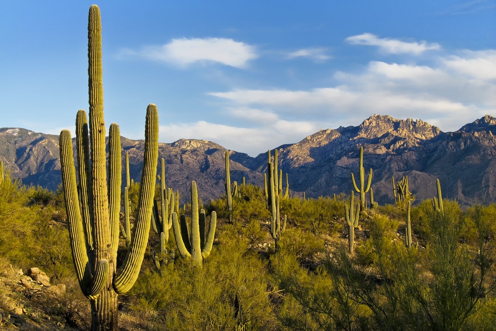
Tucson’s identity is inseparable from the Sonoran Desert that cradles it—the only place in the world where the iconic saguaro cactus grows naturally. This relationship has evolved from the survival-focused knowledge of indigenous inhabitants to contemporary conservation efforts that make Tucson a model for desert-adapted urban living.
The traditional ecological knowledge of the Tohono O’odham remains vital, particularly their understanding of harvesting desert foods like saguaro fruit, cholla buds, and mesquite pods—practices that are being revitalized through programs like Desert Harvesters and the San Xavier Cooperative Farm. These traditional practices have influenced modern desert permaculture techniques now visible throughout Tucson neighborhoods.
Outdoor recreation has deep cultural roots in the region. Horseback riding traditions connect to both vaquero culture and Anglo ranching heritage, while hunting practices blend survival skills passed down through generations with contemporary conservation ethics. Distinctive local activities include visiting natural pools called tinajas during monsoon season, night hiking to escape summer heat, and participating in the annual Tumamoc Hill walking pilgrimage.
Conservation efforts reflect Tucson’s community values, with the creation of Saguaro National Park in 1933 and the establishment of the 129,000-acre Sonoran Desert Conservation Plan—one of the most comprehensive regional conservation efforts in the nation. The Tucson Audubon Society has been instrumental in protecting habitat for the region’s remarkable bird diversity, while the Coalition for Sonoran Desert Protection brings together more than 30 environmental and community groups to advocate for wildlife corridor protection.
Water awareness shapes outdoor traditions uniquely in this desert basin. The annual celebration of monsoon rains includes the public festival of Chubasco de Tucson, while organizations like Watershed Management Group train residents in water harvesting techniques that transform yards into micro-oases using ancient and modern methods. The community’s relationship with water is perhaps best symbolized by the Santa Cruz River, which has seen portions restored to year-round flow through reclaimed water projects—a rare example of a river returning after decades of absence.
Tucson’s designation as North America’s first UNESCO City of Gastronomy in 2015 recognized what locals have long celebrated: a continuous 4,000-year history of agricultural and culinary innovation that has created one of the most distinctive food cultures in the United States.
The foundations of Tucson’s cuisine lie in the indigenous cultivation of crops adapted to desert conditions—the “Three Sisters” of corn, beans, and squash, along with native plants like tepary beans, cholla buds, and mesquite pods. The Tohono O’odham continue to preserve heirloom varieties at the San Xavier Cooperative Farm, while organizations like Native Seeds/SEARCH maintain seed banks of these desert-adapted crops.
Spanish and Mexican influences added wheat, citrus, and livestock to the culinary landscape, creating the foundations of Sonoran cuisine. The distinctive Sonoran-style flour tortilla—paper-thin, enormous, and slightly chewy—remains a staple at local tables, while dishes like carne seca (air-dried beef rehydrated with tomatoes and chilies) preserve techniques developed for desert food preservation.
Iconic local specialties include the Sonoran hot dog—a bacon-wrapped hot dog topped with beans, onions, tomatoes, mayonnaise, mustard, and jalapeño sauce in a slightly sweet bolillo bun—which migrated from Hermosillo, Mexico, to become a Tucson street food sensation. The chimichanga reportedly originated when a Tucson chef accidentally dropped a burrito into hot oil, creating a now-famous fried dish.
Contemporary Tucson cuisine builds on these traditions while incorporating influences from the many cultures that have made the city home. Restaurants like Café Poca Cosa and El Charro Café have earned national recognition for their innovative approaches to Mexican cuisine, while the cup of coffee at Exo Roast Co. might be flavored with mesquite, chiltepín chilies, or other desert ingredients.
What makes Tucson’s food culture particularly significant is how it connects past and present, with ancient techniques finding new applications in addressing contemporary challenges. Desert food harvesting skills once essential for survival now inform climate change adaptation strategies, while heritage crops preserved for cultural reasons prove to have remarkable drought resistance and nutritional profiles suited to modern health concerns.
The spaces where Tucsonans come together reflect both the community’s cultural values and its adaptation to desert living. From ancient gathering sites still in use to contemporary developments designed to foster connection, these places tell the story of how community is created and maintained in this unique environment.
Traditional gathering spaces include San Xavier del Bac Mission, where religious ceremonies, community celebrations, and cultural events have brought people together continuously since the late 17th century. Traditional ramadas—open-sided shade structures with ocotillo or saguaro rib roofs—remain common features at both public and private gathering spaces, providing necessary shelter from the desert sun while allowing cooling breezes.
Public parks serve crucial social functions, with Reid Park at the city’s center hosting everything from quinceañeras to cricket matches. Himmel Park’s dense shade trees make it a coveted summer gathering spot, while the Children’s Museum Tucson provides an indoor alternative during the hottest months. The city maintains over 128 parks, many featuring splash pads and ramadas that acknowledge the realities of desert recreation.
Markets have historically functioned as community hubs, from informal tianguis (open-air markets) to the modern Mercado San Agustín, which combines food, retail, and community events in a space designed to evoke traditional Mexican mercados. The Food Conspiracy Co-op, founded in 1971, serves as both grocery store and community organizing space for the Fourth Avenue area.
Tucson’s cafe culture has deep roots, with establishments like the Epic Cafe and Café Passe functioning as informal offices, meeting spaces, and community living rooms. The Hotel Congress, built in 1919, has transformed from a simple hotel to a multi-use venue that hosts everything from indie rock shows to senior citizen dance nights.
Contemporary developments increasingly incorporate spaces designed specifically for community gathering, often drawing on traditional concepts. The MSA Annex uses shipping containers arranged around a central courtyard to create a modern interpretation of a traditional plaza, while the Mercado District incorporates narrow streets and small front yards that encourage neighbor interaction, reflecting historic barrio design principles.
What these diverse spaces share is a quality Tucsonans call convivencia—the art of living together in community—that values face-to-face interaction, multi-generational gathering, and the blending of everyday activities with celebration that characterizes desert basin cultures worldwide.
Throughout its long history, Tucson has faced challenges that would have overwhelmed less resilient communities—from devastating floods and prolonged droughts to economic hardships and cultural conflicts. The community’s responses to these challenges reveal core values that continue to guide its development.
Water scarcity represents Tucson’s most fundamental challenge. The Santa Cruz River, once perennial, became ephemeral in the early 20th century due to groundwater pumping. This loss catalyzed a community response that has made Tucson a leader in water conservation and reclamation. The completion of the Central Arizona Project canal in 1993 brought Colorado River water to the region, while innovative water harvesting programs and tiered rate structures have reduced per capita water use by nearly 30% since the 1980s.
Economic challenges include persistent poverty, particularly in South Tucson and on adjacent tribal lands. Community responses include innovative workforce development programs like JobPath, which helps residents train for high-demand careers, and the Primavera Foundation’s social enterprise initiatives that create employment while addressing community needs.
Cultural tensions have emerged repeatedly, most visibly in debates over Mexican American Studies in schools and immigration policies at the nearby border. The community has responded with dialogue initiatives like Derechos Humanos and cultural celebration events that build understanding across differences, demonstrating a commitment to maintaining Tucson’s multicultural identity despite external pressures.
Environmental threats, including climate change impacts and habitat fragmentation, have inspired community-wide conservation efforts. The Sonoran Desert Conservation Plan, developed through extensive community input, protects crucial wildlife corridors while accommodating growth, while the Tucson Million Trees initiative addresses urban heat island effects through large-scale planting of native and desert-adapted species.
Health disparities present ongoing challenges, particularly in low-income areas where access to healthcare and healthy food remains limited. El Rio Community Health Center, founded in the 1970s, has grown to become one of the largest community health center systems in the nation, while the Garden Kitchen teaches nutrition and gardening skills in underserved communities.
Throughout these challenges, Tucson has demonstrated a remarkable capacity for creative problem-solving that draws on its cultural diversity, connection to place, and tradition of community involvement. This resilience is not about returning to a previous state after disruption, but rather about evolving to meet changing conditions while maintaining core values—a pattern visible throughout the community’s long history.
As Tucson navigates the 21st century, the community faces the perpetual challenge of all historic places: how to embrace necessary change while preserving the qualities that make it special. What distinguishes Tucson’s approach is its explicit recognition that preservation and innovation need not be oppositional.
Historic preservation in Tucson extends beyond buildings to living traditions, ecological knowledge, and community practices. The Sunshine Mile Urban Overlay District represents this integrated approach, protecting mid-century modern architecture along Broadway Boulevard while creating opportunities for mixed-use development that serves contemporary needs. Similarly, the restoration of agricultural traditions through Native Seeds/SEARCH preserves cultural heritage while advancing food security goals.
Technology adaptation follows a similar pattern of respecting tradition while embracing innovation. The Community Wireless Network provides free internet access using solar-powered towers, combining digital connectivity with the community’s commitment to renewable energy. The University of Arizona’s rainwater harvesting calculator app draws on ancient water management knowledge while employing modern technology to make these techniques accessible to homeowners.
Generational transition represents both challenge and opportunity, with young Tucsonans often leaving for economic opportunities elsewhere. Programs like the TENWEST Impact Festival and Tucson Young Professionals network create pathways for younger residents to build careers while engaging with the community’s distinctive culture. Intergenerational initiatives such as Stories that Soar! bring children and elders together to preserve community narratives while encouraging creative expression.
Residents across demographic groups express hope for a future Tucson that remains authentic to its multicultural roots, desert-adapted lifeways, and community-centered values—even as it addresses challenges of growth, climate change, and economic development. This vision is perhaps best captured in the concept of querencia, a Spanish term meaning a place where one feels at home and draws strength, which many Tucsonans use to describe their relationship with the community.
What makes Tucson more than just a collection of people living in proximity is difficult to capture in words, yet residents speak of it with deep conviction. It emerges in the golden light of late afternoon reflecting off adobe walls, in the shared excitement when the first monsoon clouds build over the mountains, and in the cross-cultural celebrations that fill the community calendar.
“Tucson gets under your skin,” explains Raquel Rubio Goldsmith, a local historian and community elder. “The desert teaches patience and attention. You can’t rush here. You have to notice the subtle changes—when the ocotillo leafs out, when the first saguaro flower opens. That way of seeing carries over into how we notice each other, how we build community.”
For Maurice Saldate, a fourth-generation Tucsonan and restaurateur, the soul of Tucson lies in its borderland nature: “We’re not fully American, not fully Mexican, but something unique that happened when those cultures met the desert and each other. That’s why our food, our music, our celebrations feel different here—they grew from this particular soil.”
University student Janessa Fernandes finds Tucson’s essence in its contradictions: “It’s small enough to run into friends at the farmers market but large enough to support world-class research. It honors ancient traditions while creating space for new ideas. That balance keeps the community alive and evolving.”
What these diverse perspectives share is recognition that Tucson’s identity emerges from the interweaving of culture, ecology, and history in ways that have created not just a distinctive place, but a way of being that residents carry with them. In a world increasingly characterized by placelessness and disconnection, Tucson stands as testimony to the enduring power of community rooted in shared heritage, meaningful traditions, and abiding connection to place.
We use cookies to improve your experience on our site. By using our site, you consent to cookies.
Manage your cookie preferences below:
Essential cookies enable basic functions and are necessary for the proper function of the website.