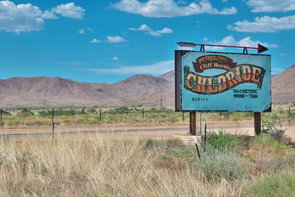
The wind whispers through the weathered wooden structures on Tennessee Avenue, carrying the faint echoes of miners’ pickaxes and the ghostly rattle of ore carts. This is Chloride, Arizona, where the harsh desert sun bleaches what remains of once-bustling saloons and mercantiles. Nestled in the Cerbat Mountains of Mohave County, 23 miles northwest of Kingman, this remote outpost once vibrated with the energy of over 2,000 souls seeking fortune in the silver-rich hills. Today, the town sits in quiet testimony to ambition’s impermanence, its pioneer dreams etched in the stones of the cemetery west of town.
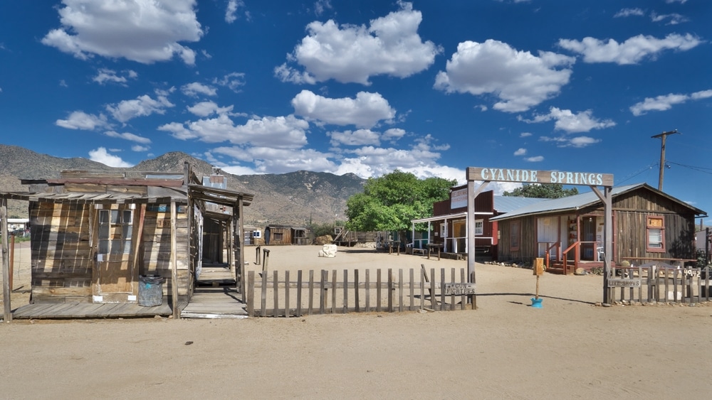
Chloride’s downtown is like an open-air museum of Arizona’s mining past. Wooden storefronts, old signage, weathered homes, and vintage mining equipment tell the story of a boomtown that once boasted saloons, hotels, and a thriving population. Walk the main street, pop into shops, and discover quirky displays around every corner—including a few lovingly maintained historic structures from the 19th century.
A must-see highlight is the Roy Purcell murals, known as the “Painted Rock Murals”, located about a mile east of town along a rough dirt road. Created in 1966 and refreshed in the 2000s, these large, psychedelic rock paintings cover boulders in brilliant colors and symbols. They blend spirituality, mythology, and modern art, and their remote desert setting makes the experience even more striking. The road is rocky—high-clearance vehicles are recommended.
The Chloride Historical Society Museum preserves the town’s rich mining heritage. Exhibits include photographs, artifacts, tools, and memorabilia from Chloride’s boom years. It’s a great stop to understand the deeper history behind the buildings and ruins scattered throughout the area.


The hills surrounding Chloride are dotted with abandoned mine shafts, tailings, and old cabins, many of which are accessible by hiking or 4×4 roads. The terrain offers excellent views of the desert valley and rugged mountains. Always use caution—do not enter mine shafts, and watch for loose rock and wildlife.

With its location at the edge of the Cerbat Mountains, Chloride is a gateway to desert backroads and OHV trails. Off-roaders can explore ghost mines, climb to mountain viewpoints, and connect with other historic sites like Mineral Park or Cerbat. Fall and spring are the best seasons for backcountry drives.

Far from city lights, Chloride offers fantastic stargazing conditions. Visitors who stay overnight in the area, whether camping or lodging, are treated to dark skies filled with stars, planets, and meteor showers during peak seasons.
| Feature | Details |
|---|---|
| Location | Mohave County, northwestern Arizona, about 23 miles northwest of Kingman |
| Founded | About 1863 as a silver mining camp; boomed 1900–1920 |
| Status | Semi-ghost town/small unincorporated community (not fully abandoned) |
| Population | 229 at the 2020 census |
| Etymology | Named for the silver chloride ore found in the surrounding hills |
| Economic History | Silver, gold, lead and zinc mining in the Cerbat Mountains |
| Mining Operation | Tennessee and Schuylkill mines were the main producers; mines closed by 1944 |
| Nearby Attractions | Roy Purcell rock murals, Cerbat Mountains, Mineral Park |
| Climate | High desert climate with hot summers and cool winters |
| Elevation | 4,009 feet (1,222 m) |
| Outdoor Recreation | Desert hiking, wildlife viewing, photography |
Founded about 1863, Chloride took its name from the silver chloride ore discovered in the surrounding mountains. Conflict with the Hualapai at first kept development limited, but after the U.S. Army subdued the Hualapai and a treaty was signed in the early 1870s, extensive mining began and Chloride grew into one of Arizona Territory’s earliest mining districts.
The Cerbat Mining District, which included Chloride, helped fuel Arizona’s territorial economy before copper became the dominant mineral resource. Silver, along with lead and zinc, drew prospectors from across the nation. By the 1870s, a small but determined community had established itself, with significant growth occurring after 1900 when a more substantial wave of development began.
The town reached its zenith between 1900 and 1920, boasting a population that swelled to over 2,000 residents. During this heyday, Chloride featured a two-story schoolhouse, a hotel, multiple saloons, stores, restaurants, and all the trappings of a proper frontier town. The economic driver remained primarily the mines, including the Tennessee, Schuylkill, and Midnight mines that yielded substantial quantities of silver alongside lead, zinc, and gold.
Chloride’s story parallels the broader narrative of Western expansion, representing the boom-and-bust cycle typical of mining communities throughout Arizona Territory. When Arizona achieved statehood in 1912, Chloride was in its prime, serving as a vivid example of how mineral wealth could transform empty desert into centers of commerce and community.
Today’s visitor to Chloride encounters a curious blend of ghost town authenticity and small-town resilience. Unlike many abandoned mining camps that have completely vanished, Chloride maintains a small permanent population (229 at the 2020 census) who treasure their town’s colorful past. Tennessee Avenue, once the main thoroughfare, still features several original structures dating to the mining era.
The old train depot, though significantly weathered, remains recognizable. The former general store building now serves as a museum housing artifacts of the town’s mining days. Yellowed newspapers, mining equipment, household items, and photographs preserve fleeting moments from Chloride’s boom years. Several false-front buildings line the street, their faded paint and tilting porches testifying to decades of desert exposure.
Beyond the semi-preserved center, foundations and stone walls mark where additional businesses and homes once stood. Mine tailings spread across the hillsides like pale scars, while the entrances to once-productive mine shafts—now safely sealed—dot the surrounding landscape. Rusted equipment including ore carts, boilers, and processing machinery lie scattered through the brush, slowly surrendering to the elements.
Preservation efforts, while modest compared to more famous ghost towns like Jerome, maintain Chloride’s authentic frontier appearance. Local residents have established the Chloride Historical Society to protect remaining structures and educate visitors. The “Chloride Days” celebration each June commemorates the town’s mining heritage with period costumes, reenactments, and tours of accessible historical sites.
Visitors can easily access Chloride year-round via Highway 93, turning east at Grasshopper Junction for the roughly four-mile drive to the historic district. The town welcomes respectful tourists, though many sites are on private property and should be viewed from designated areas only.
Chloride’s cemetery lies off the main road just west of town, where many old and unmarked graves of the mining era lie among more recent burials.
The arrival of the Arizona & Utah Railway in 1899 marked a transformative moment in Chloride’s development. The line ran up the Sacramento Valley from McConnico, near Kingman, where it connected with the Atchison, Topeka & Santa Fe, finally linking Chloride to national markets. Before the railroad, transporting ore required arduous wagon journeys over rough terrain, severely limiting production capacity.
With rail access, mines could ship lower-grade ore that previously wasn’t economically viable. The railroad also dramatically reduced the cost of importing heavy machinery, construction materials, and consumer goods. Chloride’s commercial district expanded rapidly after the rail connection, with businesses clustered near the newly built depot on the town’s eastern edge.
Freight service dominated the line’s business model, with ore cars leaving Chloride loaded with silver-bearing rock and returning with mining timbers, explosives, machinery, and merchandise for local stores.
Rail service to Chloride continued until 1935, when declining mining activity during the Great Depression brought it to an end.
Chloride’s decline began gradually after World War I, when silver prices failed to recover from wartime price controls. The 1920s saw several major mines reduce operations or close entirely as veins played out and extraction costs exceeded profits.
The Great Depression added to the pressure on remaining operations, though the larger mines kept producing into the 1940s. By 1944, rising costs of materials and labor had forced the mines to close, and the population fell dramatically.
The end of rail service reflected and accelerated this decline. When the line closed in 1935, several families and businesses that had persisted despite economic hardship finally relocated.
Chloride’s cemetery continues to receive burials to this day, alongside the many old and unmarked graves of the mining era.
Chloride stands as a remarkably intact example of Arizona’s early mining communities, offering archaeological and historical significance beyond many better-known ghost towns. Unlike Jerome or Tombstone, which developed substantial tourist infrastructure that somewhat altered their historical character, Chloride maintains a more authentic connection to its frontier origins.
For the Hualapai people, whose ancestral territory encompasses the Cerbat Mountains, Chloride represents a complex historical intersection.
Chloride plays a modest but growing role in regional tourism, attracting visitors interested in authentic Western history beyond the more commercialized destinations. The town’s remote location has paradoxically helped preserve its character by limiting development pressure.
The community’s railroad history provides valuable case studies for understanding how communication and transportation networks shaped territorial Arizona. Similarly, the railroad spur line demonstrates how even secondary connections to national rail networks could dramatically transform local economies.
Visitors to Chloride’s historic sites should approach with respect for both the community’s past and its present residents. The small population that maintains homes in the area welcomes respectful tourism but deserves consideration. Private property boundaries should be observed, particularly around residential structures and active mining claims.
Chloride’s cemetery remains an active burial ground with family connections to current residents, so visit quietly and respectfully.
Archaeological resources beyond the cemetery and townsite face ongoing threats from scavenging and unauthorized metal detecting. Removing artifacts from public lands violates the Archaeological Resources Protection Act and diminishes the historical record for future researchers and visitors.
The Chloride Historical Society operates a small museum on weekends that provides orientation information, historical photographs, and artifact displays that contextualize the surviving structures. Donations to this organization help support preservation efforts throughout the historic district.
Standing in Chloride today, with the desert wind stirring dust along Tennessee Avenue and ravens calling from atop weathered wooden false fronts, one confronts the impermanence of human ambition. The town that silver built—once home to thousands, served by a railroad—now slumbers as a quiet reminder of boom-and-bust cycles that defined the American West.
As contemporary Arizona continues its rapid urbanization, places like Chloride offer essential perspective on our relationship with the landscape and resources. The town reminds us that settlements once considered permanent can fade when economic patterns shift or resources deplete. Yet it also demonstrates how human connections to place persist beyond economic utility, as descendants continue to honor their ancestors in hillside graves and preserve the stories of a community that refused to be forgotten.
Paher, Stanley W., Roy E. Purcell and Charles Kinsey. Chloride: Mines and Murals. Nevada Publications, 1978.
Lingenfelter, Richard. The Hardrock Miners: A History of the Mining Labor Movement in the American West. University of California Press, 1974.
Trimble, Marshall. Arizona: A Panoramic History of a Frontier State. Doubleday, 1977.
Chloride is located approximately 23 miles northwest of Kingman, Arizona. From Highway 93, turn east at Grasshopper Junction and follow the road about 4 miles to the historic district.
GPS Coordinates:
We use cookies to improve your experience on our site. By using our site, you consent to cookies.
Manage your cookie preferences below:
Essential cookies enable basic functions and are necessary for the proper function of the website.
Statistics cookies collect information anonymously. This information helps us understand how visitors use our website.
Monetize your website by displaying targeted ads and earning revenue from clicks and impressions.
Google Analytics is a powerful tool that tracks and analyzes website traffic for informed marketing decisions.
Service URL: policies.google.com (opens in a new window)
You can find more information about our Cookie Policy and Privacy Policy.


