Rising dramatically from the desert floor to an elevation of 3,374 feet, Picacho Peak stands as an iconic landmark along Interstate 10 between Phoenix and Tucson. Picacho Peak State Park, established in 1968, encompasses 3,747 acres of stunning Sonoran Desert landscape centered around this distinctive geological formation. The park is located approximately 60 miles south of Phoenix (GPS coordinates: 32.6425° N, 111.3996° W) and serves as both a visual beacon for travelers and a recreational haven for outdoor enthusiasts.
The name “Picacho” derives from the Spanish word meaning “peak,” and this aptly named formation has been a significant navigational landmark for centuries. Indigenous peoples, Spanish explorers, Gold Rush travelers, the Butterfield Overland Mail stagecoach, and the Southern Pacific Railroad all used Picacho Peak as a waypoint. Perhaps most notably, the area was the site of the westernmost battle of the American Civil War. On April 15, 1862, the Battle of Picacho Pass was fought near the peak, with Union cavalry from California clashing with Confederate scouts from Tucson.
Today, Picacho Peak State Park stands as one of Arizona’s most recognizable and visited state parks, drawing approximately 100,000 visitors annually. The park offers a unique combination of historical significance, challenging hiking trails, seasonal wildflower displays, and panoramic desert vistas that showcase the raw beauty of the Sonoran Desert.
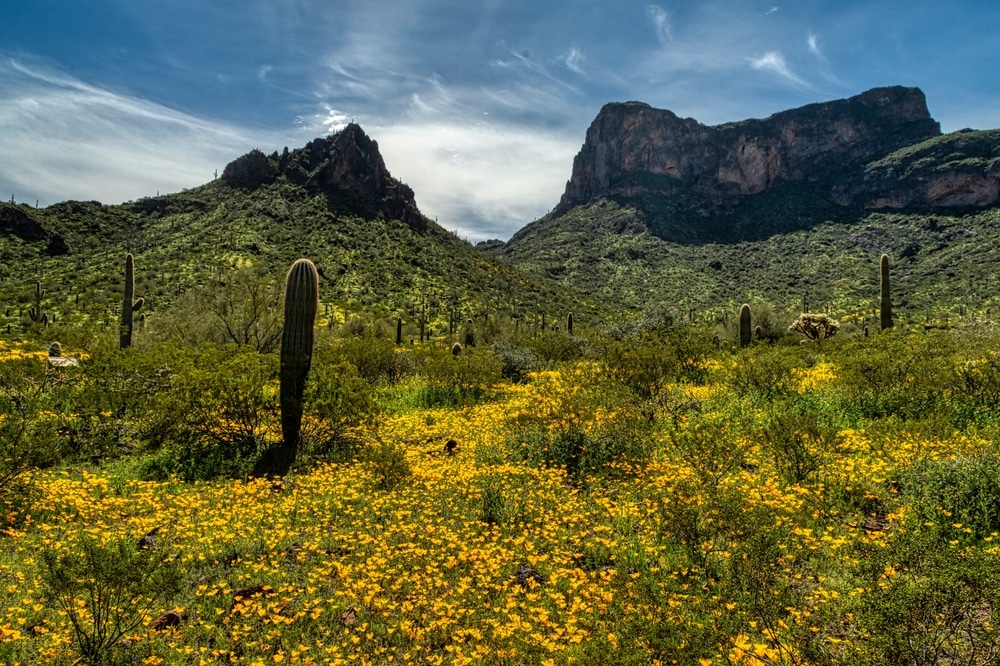
Visitors to Picacho Peak are treated to a diverse range of experiences, from the adrenaline rush of scaling the peak via steel cables to peaceful desert camping beneath star-filled skies. The park is particularly renowned for its spectacular spring wildflower blooms, when the desert floor transforms into a vibrant carpet of gold, purple, and red, dominated by Mexican poppies, lupines, and owl clover.
Within Arizona’s state park system, Picacho Peak serves as a crucial preservation area for Sonoran Desert ecology while providing accessible outdoor recreation opportunities along a major travel corridor, bridging the gap between Arizona’s two largest metropolitan areas.

During spring months, especially following wet winters, Picacho Peak becomes famous for spectacular wildflower displays. Mexican gold poppies carpet the hillsides with vibrant yellow blooms, complemented by lupines, brittlebush, globemallow, and numerous cactus flowers. The Sunset Vista Trail offers particularly impressive wildflower viewing, though colorful displays can be enjoyed throughout the park. Rangers provide updates on blooming conditions, which typically peak between mid-February and early April.

While technical rock climbing is limited, the park’s unique volcanic formations offer bouldering opportunities and scrambling experiences, particularly along the cable-assisted sections of summit trails. These routes provide exhilarating challenges for those comfortable with exposure and basic climbing techniques. Proper footwear and gloves are strongly recommended for the cable sections, which can be slippery and abrasive.

Picacho Peak’s distinctive silhouette against the desert sky creates exceptional photography opportunities throughout the day. Sunrise casts a golden glow on the eastern face, while sunset illuminates the western slopes with dramatic light. Spring wildflower seasons transform the landscape with vibrant colors, while summer monsoon storms create dramatic cloud formations behind the peak. The park’s elevated viewpoints offer panoramic vistas of surrounding mountain ranges and vast desert expanses.

Picacho Peak State Park offers several dramatic hiking trails centered around its iconic 1,500-foot volcanic spire. The Hunter Trail provides the most direct route to the summit, featuring steel cables and handrails to assist hikers through steep sections. The Sunset Vista Trail offers a longer but equally rewarding approach to the peak with panoramic desert views. The Children’s Cave Trail and Nature Loop provide easier alternatives for those seeking less strenuous experiences. These trails are most comfortably hiked from late fall through early spring when temperatures are moderate.

Multiple day-use areas throughout the park offer picnic tables, grills, and shade ramadas with spectacular views of Picacho Peak. These facilities are strategically placed to take advantage of scenic vistas while providing comfort in the often sunny environment. Group picnic areas with larger capacity are available by reservation for family gatherings and special events.

The diverse desert habitats support numerous bird species, from tiny verdins and cactus wrens to impressive raptors like red-tailed hawks and prairie falcons. Spring migration brings additional species through the area, while resident birds offer year-round viewing opportunities. The park provides bird checklists to help visitors identify local species, with the Nature Loop Trail offering particularly good birding habitat.

The park maintains 85 developed campsites accommodating tents and RVs with electric hookups available. Each site includes a picnic table, fire ring, and grill, with modern restrooms and hot showers nearby. The campground’s setting at the base of Picacho Peak provides dramatic views and convenient access to trailheads. Reservations are recommended during the popular spring season when wildflower displays attract numerous visitors.

| Detail | Information |
|---|---|
| Location | Between Phoenix and Tucson, Arizona (I-10 corridor) |
| Established | 1968 |
| Size | 3,747 acres |
| Main Feature | Picacho Peak (3,374 feet elevation) |
| Geological Origin | Volcanic in origin, formed by lava flows and tectonic activity |
| Historical Significance | Site of the westernmost Civil War battle (April 15, 1862) |
| Battle Name | Battle of Picacho Pass |
| Trails | 9 hiking trails of varying difficulty |
| Notable Trails | Hunter Trail (summit access), Sunset Vista Trail, Children’s Cave Trail |
| Trail Difficulty | Moderate to difficult with steel cables assisting steep sections |
| Flora | Sonoran Desert vegetation: saguaro, ocotillo, cholla, palo verde |
| Wildlife | Coyotes, jackrabbits, mule deer, desert tortoises, various birds |
| Seasonal Highlight | Spectacular wildflower blooms (February-April) |
| Camping | 85 campsites with electric hookups, picnic tables, grills |
| Activities | Hiking, camping, picnicking, wildlife viewing, photography |
| Annual Event | Civil War reenactment (typically in March) |
| Best Time to Visit | October through April (cooler temperatures) |
Picacho Peak stands as a stark volcanic remnant, rising approximately 1,500 feet above the surrounding desert plain. This distinctive landmark, visible for miles along Interstate 10, was formed through volcanic activity approximately 22 million years ago. Unlike many mountains that feature a single summit, Picacho Peak presents a complex silhouette with multiple spines and saddles, creating its unmistakable profile against the Arizona sky.
Geologically, the peak is composed primarily of rhyolite, a volcanic rock similar to granite but formed through different processes. What makes Picacho Peak particularly interesting to geologists is its unusual tilted structure. The mountain was originally part of a much larger volcanic formation, but tectonic forces over millions of years caused it to tilt approximately 15 degrees from its original position. Subsequent erosion sculpted the distinctive features visible today, including the dramatic cliffs and precarious overhangs that challenge hikers.
The surrounding landscape exemplifies classic Sonoran Desert terrain, with gently rolling bajadas (alluvial fans) extending from the base of the peak. These slopes are characterized by sandy soil interspersed with desert pavement—areas where closely packed pebbles create a natural mosaic on the ground surface. Several dry washes cut through the park, channeling rare rainfall through arroyos that support more dense vegetation than the surrounding desert.
While there are no permanent water features within the park boundaries, seasonal rainfall does create temporary pools in rocky depressions and washes. The park sits within the Santa Cruz River watershed, though the river itself flows several miles to the east. During monsoon season (typically July through September), dramatic thunderstorms can transform dry washes into temporary streams, showcasing the desert’s rapid response to precipitation.
The elevation within the park ranges from approximately 1,800 feet at its lowest point to 3,374 feet at the summit of Picacho Peak. This elevation gradient, though modest compared to some of Arizona’s mountain ranges, creates noticeable changes in vegetation and provides the varied terrain that makes the park’s hiking trails so diverse in character and challenge level.
From a distance, Picacho Peak appears almost barren, particularly during dry periods. However, closer inspection reveals a landscape teeming with specialized desert life, perfectly adapted to the harsh conditions. The peak and its surrounding terrain represent a vital island of protected habitat within an increasingly developed corridor, preserving a snapshot of the Sonoran Desert ecosystem for future generations.
Picacho Peak State Park showcases the remarkable biodiversity of the Sonoran Desert, the most ecologically diverse desert in North America. The park serves as a protected habitat for numerous plant and animal species that have evolved specialized adaptations to thrive in this challenging environment.
The vegetation of Picacho Peak exhibits classic Sonoran Desert characteristics, dominated by a variety of cacti and drought-resistant shrubs. The iconic saguaro cactus (Carnegiea gigantea) stands sentinel throughout the park, some specimens reaching heights of over 40 feet and ages exceeding 150 years. These majestic plants are joined by several other cacti species, including barrel cactus (Ferocactus wislizeni), cholla varieties (Cylindropuntia spp.), prickly pear (Opuntia spp.), and the diminutive hedgehog cactus (Echinocereus spp.).
The park’s woody vegetation includes mesquite trees (Prosopis spp.), paloverde (Parkinsonia spp.), ironwood (Olneya tesota), and creosote bush (Larrea tridentata). These plants provide critical habitat and food sources for wildlife while showcasing remarkable adaptations to conserve water and withstand extreme temperatures.
Spring transforms Picacho Peak, particularly following wet winters, when wildflowers carpet the desert floor in spectacular displays. Mexican gold poppies (Eschscholzia mexicana) often dominate these blooms with their vibrant orange-yellow flowers, accompanied by purple lupines (Lupinus sparsiflorus), blue phacelia (Phacelia distans), white desert chicory (Rafinesquia neomexicana), and numerous other annual wildflowers. The peak blooming period typically occurs from late February through early April, drawing photographers and nature enthusiasts from across the country.
Wildlife abounds within the park boundaries, though many species remain elusive during daylight hours. Mammals include desert cottontails, black-tailed jackrabbits, ground squirrels, coyotes, javelinas (collared peccaries), and the occasional bobcat or mountain lion. Reptiles are well-represented with several lizard species, including the colorful western whiptail and common chuckwalla, along with snakes such as the non-venomous gophersnake and the venomous western diamondback rattlesnake.
The park serves as important habitat for numerous bird species, making it a notable destination for birders. Year-round avian residents include Gambel’s quail, cactus wren, curve-billed thrasher, and several species of hawks and owls. During migration seasons, the variety increases substantially as birds move through the region. Notable species include verdins, black-throated sparrows, gilded flickers, and the striking red-tailed hawk often seen soaring above the peak.
Seasonal changes dramatically affect wildlife activity patterns. During summer months, most animals adopt crepuscular (dawn and dusk) or nocturnal habits to avoid extreme daytime temperatures often exceeding 100°F. Winter brings more visible daytime activity as temperatures moderate, providing visitors better wildlife viewing opportunities, particularly in early morning hours.
While no federally listed endangered species are known to regularly inhabit the park, the area provides important habitat connectivity within an increasingly fragmented landscape, supporting regional biodiversity conservation efforts throughout the Sonoran Desert ecosystem.
Picacho Peak State Park offers diverse recreational opportunities centered around its dramatic desert landscape and iconic peak. Whether seeking adventure, relaxation, or nature appreciation, visitors can find activities suited to various interests and ability levels.
Hiking remains the premier attraction at Picacho Peak, with a network of trails showcasing different aspects of the park’s terrain. The signature trail is undoubtedly the Hunter Trail (2 miles one-way), which challenges hikers with a steep ascent to the summit. This difficult trail includes sections with steel cables and handrails to assist hikers through near-vertical segments. Those who complete this strenuous hike are rewarded with breathtaking 360-degree views spanning dozens of miles on clear days. Proper preparation is essential, as this trail requires gloves for the cables, sturdy footwear, and at least 2-3 liters of water per person.
For those seeking a less demanding experience, the Calloway Trail (0.7 miles one-way) connects with the Hunter Trail and provides scenic vistas without reaching the summit. The Nature Trail (0.5 miles) offers an accessible, self-guided interpretive experience focusing on desert ecology. The Children’s Cave Trail (0.2 miles) leads to a small rock formation popular with families. The Sunset Vista Trail (3.1 miles one-way) provides a longer alternative route to the peak, with more gradual elevation gain before connecting with the Hunter Trail’s upper section.
ALERT: Hiking Safety
Hiking to Picacho Peak’s summit is extremely strenuous and potentially dangerous in hot weather. Trails to the peak are closed when temperatures exceed 105°F. Always check weather forecasts, carry ample water (1 gallon per person recommended), wear appropriate footwear, and bring gloves for cable sections. No hiking should be attempted during lightning storms due to exposed terrain.
Photography opportunities abound throughout the park, with the dramatic peak, seasonal wildflowers, desert landscapes, and wildlife providing compelling subjects. For optimal lighting, photographers often visit during early morning or late afternoon when the low-angle sunlight accentuates the textures of the peak and surrounding desert. Spring wildflower season (typically February-April) offers spectacular macro and landscape opportunities, while monsoon season brings dramatic skies and storm photography possibilities.
While the park contains no bodies of water for fishing or water recreation, it excels as a destination for night sky viewing. Located away from major city light pollution, Picacho Peak offers impressive stargazing opportunities. The park occasionally hosts astronomy events in partnership with local astronomy clubs, featuring telescope viewings and educational programs. Visitors staying overnight at the campground can enjoy spectacular night skies, with the Milky Way clearly visible during new moon periods.
Picnicking facilities are available in developed areas near the visitor center, with ramadas providing welcome shade. These areas feature tables, grills, and nearby restroom facilities, making them popular for family gatherings and brief stops.
Bird watching represents another popular activity, particularly during spring and fall migration periods. The varied terrain supports diverse bird habitats, with species ranging from tiny verdins to soaring hawks. The park provides a bird checklist available at the visitor center to assist enthusiasts in identifying species.
For those interested in historical recreation, interpretive displays throughout the park detail the area’s Civil War history, with special attention to the Battle of Picacho Pass. Each March, a historical reenactment of this westernmost Civil War battle draws history enthusiasts from across the region, though the reenactment takes place on private land adjacent to the park rather than within park boundaries.
During spring wildflower blooms, botanical appreciation becomes a primary activity, with casual visitors and serious botanists alike marveling at the desert’s vibrant transformation. The intensity and timing of these blooms vary annually depending on winter rainfall patterns, with park staff providing bloom updates through social media and the official website.
Picacho Peak State Park offers a well-maintained campground that provides visitors the opportunity to experience the Sonoran Desert’s stark beauty and remarkable night skies. The campground features 85 developed sites suitable for various camping styles, divided into different loops to accommodate different preferences and equipment.
Of the 85 total sites, 70 offer electric (50/30/20-amp) and water hookups, making them ideal for RVs and travel trailers. The remaining 15 sites are designated for tent camping, positioned to take advantage of natural windbreaks and shade opportunities. Each campsite includes a picnic table, fire ring with grill, and cleared tent pad area. The maximum RV length accommodated is 45 feet, though park managers recommend calling ahead if your vehicle exceeds 40 feet to ensure appropriate site assignment.
QUICK FACTS: Campground Information
• 85 total campsites (70 with electric/water hookups) • Maximum RV length: 45 feet • Reservations: Required between October and April; recommended year-round • Fee: $30/night for electric sites, $25/night for non-electric sites (as of 2025) • Reservation window: Up to 12 months in advance • Maximum stay: 14 consecutive days
Campground amenities include modern restroom facilities with hot showers, a sanitary dump station, potable water stations, and trash/recycling collection points. While individual sites do not offer sewer hookups, the centrally located dump station is easily accessible when entering or exiting the campground. Each campsite is reasonably spacious, with approximately 35-40 feet between sites, providing a balance between community atmosphere and privacy.
Reservations are strongly recommended and can be made up to 12 months in advance through the Arizona State Parks reservation system online or by phone (1-877-MY-PARKS). During the peak visitation season (October through April), reservations are essentially required as the campground frequently reaches capacity, particularly on weekends and during wildflower season. The summer months offer more availability due to extreme heat, though camping during this period is recommended only for experienced desert campers with appropriate cooling capabilities.
For visitors seeking more comfortable accommodations, the park itself does not offer cabins or developed lodging. However, several options exist in nearby communities:
Camping regulations at Picacho Peak are designed to protect the fragile desert environment while ensuring a quality experience for all visitors. Quiet hours are enforced from 10:00 PM to 6:00 AM, with generator use restricted to 8:00 AM through 8:00 PM. Campfires are permitted only in designated fire rings and may be prohibited during periods of extreme fire danger. Collection of any natural materials (wood, plants, rocks) is strictly prohibited—all firewood must be commercially purchased and preferably heat-treated to prevent pest introduction.
INSIDER TIP: Campsite selection can significantly impact your comfort. During winter months, sites 1-25 receive more morning sun (warming tents earlier), while sites 50-85 offer better sunset views. Sites 30-45 generally provide the best mountain views. For maximum privacy, consider midweek visits when occupancy is lower.
For those new to desert camping, park rangers recommend several specific preparations:
While primitive backcountry camping is permitted in some Arizona State Parks, Picacho Peak does not allow camping outside of the developed campground due to the sensitive desert environment and to protect the park’s unique ecological and geological features.
Picacho Peak State Park operates year-round, though visitation patterns and operating hours vary seasonally due to Arizona’s climate extremes. The park gates are open from 5:00 AM to 10:00 PM daily, with the visitor center operating from 8:00 AM to 5:00 PM September through May, and 8:00 AM to 4:00 PM June through August.
Entrance fees for Picacho Peak State Park (as of 2025) are:
Payment methods accepted include cash, major credit cards, and debit cards. The entrance station is staffed during peak hours, with self-pay envelopes available during off-hours.
The optimal time to visit Picacho Peak depends largely on your interests and heat tolerance. The park experiences four distinct visitation seasons:
Peak Season (February-April): This represents the ideal visiting period for most travelers. Temperatures range from lows of 45-55°F to highs of 70-85°F. Wildflower blooms typically peak in March, turning the desert floor into a spectacular carpet of color. Trail conditions are optimal, and all park facilities operate at full capacity. However, this period also brings the highest visitation levels, particularly on weekends and holidays. Advance camping reservations are essential, ideally 3-6 months ahead.
Shoulder Season (October-January & May): These months offer pleasant temperatures with fewer crowds. Daytime highs range from 65-90°F with overnight lows between 40-60°F. The desert landscape, while not as vibrantly colorful as spring, displays subtle beauty with occasional late fall or early spring blooms. Wildlife viewing opportunities often improve during these quieter months.
Summer Season (June-September): Extreme heat dominates summer, with daytime temperatures regularly exceeding 100°F and occasionally reaching 110°F or higher. Hiking to the peak is discouraged and sometimes prohibited during extreme heat. Early morning activities (before 9:00 AM) remain viable options, and the campground is rarely full, offering solitude for experienced desert travelers. Monsoon season (typically July-September) brings spectacular thunderstorms but also flash flood risks in washes.
Weather considerations should factor heavily into trip planning. The Sonoran Desert receives approximately 10 inches of annual rainfall, primarily during winter storms and summer monsoons. Winter storms tend to bring gentle, sustained precipitation, while summer monsoons feature localized but intense thunderstorms often accompanied by lightning, high winds, and flash flooding potential. Temperature fluctuations between day and night can exceed 30°F, particularly in spring and fall.
SEASONAL ALERT
Summer visitors should exercise extreme caution due to heat risks. Temperatures above 105°F are common from June through August. Hiking during these conditions can be life-threatening. Early morning activity (completed before 10:00 AM) is strongly recommended during summer months.
Accessibility information for visitors with disabilities includes:
Pet policies allow leashed pets (maximum 6-foot leash) in the campground, picnic areas, and on the Calloway Trail only. Pets are not permitted on the Hunter Trail or Sunset Vista Trail due to challenging terrain and steel cable sections. Owners must clean up after their pets, and animals may not be left unattended at campsites. Pet waste stations are provided at trailheads and throughout the campground.
Regarding connectivity, cell service within the park ranges from moderate to poor depending on carrier and exact location. Verizon typically offers the strongest coverage, while other carriers may be limited to the visitor center area. Wi-Fi is not currently available within the park, though the visitor center does maintain landline communications for emergencies. Many visitors appreciate the opportunity to disconnect, though those requiring constant connectivity should prepare accordingly.
Picacho Peak State Park maintains a range of facilities designed to enhance visitor experiences while preserving the natural desert setting. The park strikes a balance between providing necessary amenities and maintaining the wilderness character that draws visitors to this distinctive landscape.
The park’s visitor center serves as the primary hub for information and services, located just inside the main entrance. This adobe-style building houses interpretive displays on the park’s natural and cultural history, focusing on desert ecology, the area’s Civil War significance, and geological information about the peak itself. The center is staffed by knowledgeable park rangers who provide trail recommendations, safety information, and updates on current park conditions. A small gift shop offers educational materials, field guides, appropriate hiking gear (including gloves for the cable sections), and commemorative items.
Adjacent to the visitor center, visitors will find well-maintained restroom facilities with flush toilets and sinks. Additional restroom buildings are strategically located throughout the park, including near major trailheads and within the campground area. The campground restrooms include hot shower facilities available to both overnight campers and day users.
For day visitors, Picacho Peak offers three primary picnic areas with a total of 32 individual sites:
Each picnic site includes a table with sun ramada, BBQ grill, and nearby access to restrooms and water fountains. Four larger group ramadas are available by reservation for gatherings up to 50 people, ideal for family reunions, educational groups, or special events. These group areas include multiple tables, larger grills, water access, and dedicated parking.
QUICK FACTS: Facilities Summary
- Visitor Center: Open daily, hours vary seasonally
- Restrooms: 5 locations throughout the park
- Picnic Sites: 32 individual sites, 4 group ramadas
- Water: Available at visitor center, campground, and all picnic areas
- Trash/Recycling: Collection points at all developed areas
- Trails: 5 maintained trails totaling approximately 9 miles
- Parking: 120 spaces distributed among visitor center, trailheads, and picnic areas
The park currently does not offer concessions or dining facilities, though vending machines providing water and limited snacks are located near the visitor center. Visitors should come prepared with necessary food and supplies. The nearest comprehensive services are available in Eloy (10 miles north) or Picacho (5 miles south), with more extensive options in Casa Grande (25 miles northwest) and Tucson (45 miles south).
For specialized recreation, Picacho Peak features an open-air amphitheater with seating for approximately 75 people, used for ranger programs, educational presentations, and occasional special events. These programs typically focus on desert ecology, astronomy, or historical topics, with schedules posted at the visitor center and on the park website.
Drinking water is available from spigots and fountains located throughout developed areas of the park. However, all trails lack water access, so hikers must carry adequate supplies. This is particularly critical on the challenging Hunter and Sunset Vista Trails, where dehydration poses a serious risk, especially during warmer months.
Park maintenance reflects Arizona State Parks’ commitment to sustainability. Solar panels supplement power needs at the visitor center, and the park employs water conservation measures throughout its facilities. Native plant landscaping around developed areas demonstrates appropriate desert gardening techniques while providing wildlife habitat.
All park facilities receive regular maintenance, with restrooms cleaned multiple times daily during peak season. Trails undergo seasonal maintenance, with particular attention to the cable sections on the peak ascent routes. Park staff conduct regular safety inspections of these specialized trail features, particularly after storm events.
For visitors with specific accommodation needs, the park staff encourages contacting the visitor center in advance to discuss available options and assistance. While the rugged terrain necessarily limits some accessibility, park management strives to ensure all visitors can experience the unique natural setting of Picacho Peak to the greatest extent possible.
Picacho Peak State Park’s strategic location along the Interstate 10 corridor between Phoenix and Tucson makes it an excellent anchor point for exploring additional attractions in south-central Arizona. Visitors extending their stay in the region will find diverse experiences within easy driving distance.
Just 20 miles northwest of Picacho Peak, Casa Grande Ruins National Monument preserves the remarkable remains of a four-story earthen structure built by the ancient Hohokam people approximately 650 years ago. This archaeological site provides fascinating insights into the sophisticated irrigation civilization that once thrived in the Sonoran Desert. The monument offers guided tours, interpretive exhibits, and a visitor center that eloquently explains the site’s significance in Native American history.
The charming town of Florence, located 35 miles northeast of Picacho Peak, offers a well-preserved historic district with adobe buildings dating to Arizona’s territorial period. The McFarland State Historic Park, housed in a former courthouse, provides exhibits on regional history. Florence also hosts several local restaurants serving authentic southwestern cuisine in historic settings.
For those interested in additional outdoor recreation, Catalina State Park lies 40 miles southeast near Tucson. This park features spectacular hiking trails through foothills of the Santa Catalina Mountains, with riparian areas supporting lush vegetation unusual for southern Arizona. The contrast between Catalina’s wooded canyons and Picacho’s stark desert landscape demonstrates the remarkable ecological diversity found within relatively short distances in Arizona.
Outdoor enthusiasts might consider a visit to the Ironwood Forest National Monument, approximately 30 miles southwest of Picacho Peak. This less-developed conservation area protects magnificent stands of desert ironwood trees, some potentially 800 years old, along with exceptional Sonoran Desert biodiversity. The monument offers primitive roads for high-clearance vehicles and undeveloped hiking opportunities for those seeking a more solitary desert experience.
For visitors with children, Rooster Cogburn Ostrich Ranch (5 miles south of Picacho Peak) provides interactive experiences with ostriches, stingrays, and other animals. This family-friendly attraction offers feeding opportunities and educational presentations about these unique creatures.
The communities surrounding Picacho Peak offer various services for travelers:
Eloy (10 miles north):
Casa Grande (25 miles northwest):
Tucson (45 miles south):
Visitors traveling between Phoenix and Tucson might consider Picacho Peak as part of a multi-stop journey along what locals call the “Back Road” – State Route 79 through Florence and Oracle, which offers a more scenic alternative to Interstate 10 for those not pressed for time. This route passes near several mining communities with rich Arizona history and provides access to additional outdoor recreation areas.
Those with interest in astronomy should note that the area southwest of Picacho Peak has minimal light pollution, with several world-class observatories located in the region. The University of Arizona’s Mt. Lemmon SkyCenter (north of Tucson) offers public observing programs that allow visitors to experience the exceptional dark skies that make southern Arizona a global center for astronomical research.
Picacho Peak State Park represents an important conservation success within Arizona’s state park system, preserving a distinctive landmark and protecting a functioning desert ecosystem within an increasingly developed corridor. The park’s management balances recreational access with environmental protection through careful planning and ongoing stewardship initiatives.
Current conservation efforts within the park focus on several key areas. Habitat restoration projects target areas previously disturbed by human activity, with particular emphasis on combating invasive species such as buffelgrass (Pennisetum ciliare) and fountain grass (Pennisetum setaceum). These non-native grasses threaten native plant communities and increase wildfire risk in an ecosystem not adapted to frequent burning. Park staff, often assisted by volunteers, conduct regular surveys and removal operations to control these invasive plants before they become established.
Trail management represents another critical conservation focus. The park’s popular hiking routes experience significant erosion pressure due to heavy use and occasional intense rainfall. Staff implement sustainable trail design principles during maintenance, including water diversion features, reinforced switchbacks, and strategic revegetation of closed social trails. These efforts minimize the recreational footprint while maintaining safe access to the park’s most popular features.
Wildlife monitoring programs track the presence and health of indicator species throughout the park. Motion-activated wildlife cameras positioned at strategic locations document species diversity and movement patterns, helping managers understand how animals utilize the protected habitat. Recent monitoring has documented continued use by sensitive species including kit foxes, badgers, and various raptor species, indicating the park continues to provide quality habitat despite increasing regional development.
Visitors play a crucial role in conservation efforts through responsible recreation practices. The park promotes Leave No Trace principles through interpretive signage, visitor guides, and ranger programs. These seven principles include:
Educational programming represents one of the park’s most effective conservation tools. Rangers conduct interpretive hikes, campground talks, and school field trip programs that build appreciation for desert ecology and cultural history. These educational efforts help develop a constituency of informed visitors who understand the value of desert conservation. The park’s Junior Ranger program provides children with age-appropriate activities that foster early connections with natural environments.
Volunteer opportunities allow dedicated visitors to contribute directly to park stewardship. The park hosts regular volunteer work days focusing on trail maintenance, habitat restoration, and facility improvements. For those seeking ongoing involvement, the Arizona State Parks volunteer program offers positions ranging from campground hosts to visitor center assistants. These volunteers contribute thousands of hours annually, extending the park’s capacity for both maintenance and visitor services.
Climate change presents growing challenges for park management. Increasing temperatures, changing precipitation patterns, and greater weather variability impact both natural systems and visitor safety. In response, park managers have implemented more frequent trail closures during extreme heat, enhanced emergency response protocols, and monitoring programs to track ecological changes over time.
Partnerships enhance conservation efforts through collaboration and shared resources. The park works closely with organizations including the Arizona Native Plant Society, local astronomy clubs, the Arizona Game and Fish Department, and various educational institutions. These partnerships leverage specialized expertise and expand the park’s capacity for research, monitoring, and public education.
Through these diverse stewardship initiatives, Picacho Peak State Park continues to protect a remarkable landscape while providing meaningful connections between visitors and the Sonoran Desert environment. As pressures on natural lands increase throughout the region, the park’s role in both ecological conservation and environmental education grows increasingly significant.
The distinctive silhouette of Picacho Peak has served as a landmark for diverse peoples throughout centuries of human history in the Sonoran Desert. Understanding this cultural context enriches the visitor experience by connecting recreational activities with the area’s deep historical significance.
Indigenous connections to Picacho Peak span thousands of years. Archaeological evidence indicates that the Hohokam people, ancestors of today’s O’odham Nations, traversed this area between approximately 300 BCE and 1450 CE. While they did not establish permanent settlements at the peak itself, they recognized it as an important landmark along trade routes connecting communities along the Santa Cruz and Gila River valleys. The name “Picacho” derives from the Spanish language, but local O’odham people knew the peak as “Tsékachu,” meaning “black shadow” in their language, referring to the dark silhouette it casts against the desert sky.
Spanish explorers entered the region in the 1500s, with expeditions led by Marcos de Niza and Francisco Vásquez de Coronado likely passing within sight of the peak. By the late 1600s, Jesuit missionary Father Eusebio Kino established a network of missions throughout the region, using landmarks like Picacho Peak for navigation between indigenous communities. Spanish colonial maps from the 1700s clearly identify the peak as “Picacho,” solidifying this name in recorded history.
The area gained new significance during the Mexican-American War (1846-1848) when the peak served as a waypoint for the Mormon Battalion, a volunteer unit of the U.S. Army consisting primarily of Latter-day Saints who marched from Council Bluffs, Iowa, to San Diego, California. Their difficult journey through this section of desert is commemorated by a plaque near the visitor center.
Perhaps the most famous historical event associated with Picacho Peak occurred during the American Civil War. On April 15, 1862, Union cavalry from California and Confederate scouts from Tucson clashed in what became known as the Battle of Picacho Pass. While the engagement involved only about 30 soldiers total (resulting in three Union deaths and three Confederate prisoners), it holds historical distinction as the westernmost battle of the Civil War. This skirmish represented part of a larger Confederate strategy to establish control over the Southwest and potentially access California’s ports, ambitions that ultimately failed as Union forces secured the territory.
Following the Civil War, development of the Southern Pacific Railroad in the 1880s brought increased activity to the area. Construction camps temporarily housed workers building the transcontinental line that passed near the base of the peak. Once completed, the railroad brought new settlers to the region, leading to ranching operations in the surrounding valleys.
Mining played a role in local history as well, though not directly at Picacho Peak. Several small mining operations established in nearby hills extracted limited quantities of gold, silver, and copper in the late 19th and early 20th centuries. Evidence of these activities can still be found on private lands outside park boundaries.
The modern history of Picacho Peak as a protected area began in the 1950s when concerned citizens advocated for preserving the landmark from potential development or resource extraction. Their efforts succeeded in 1968 when Arizona State Parks established Picacho Peak State Park, initially encompassing 3,747 acres. Development of visitor facilities progressed gradually, with campgrounds, trails, and the visitor center constructed in phases over subsequent decades.
Today, the park’s cultural resources are managed under policies that balance preservation with education and access. Archaeological sites receive protective monitoring, and state laws prohibit disturbance or collection of artifacts. Interpretive programs highlight the area’s multicultural heritage, acknowledging indigenous connections, Spanish colonial influences, and American settlement patterns.
The annual Civil War reenactment of the Battle of Picacho Pass, typically held in March, represents one of the park’s most popular cultural events. This living history demonstration brings the area’s Civil War connection to life through period costumes, weaponry demonstrations, and educational programs about 1860s military and civilian life. While the actual reenactment occurs on private land adjacent to the park, related interpretive activities take place within park boundaries throughout the weekend event.
For visitors interested in cultural history, the park offers a self-guided historical tour with interpretive signage explaining key events and highlighting how different cultures perceived and utilized the landmark throughout history. The visitor center houses artifacts recovered from archaeological surveys and historical photographs documenting changes to the landscape over time.
Through preservation and interpretation of these cultural resources, Picacho Peak State Park honors the diverse peoples who found significance in this dramatic landscape long before it became a recreational destination. This historical context adds depth to the visitor experience, connecting contemporary outdoor enjoyment with centuries of human interaction with this iconic Sonoran Desert landmark.
The optimal hiking season runs from October through April, with March typically offering the most comfortable temperatures and potential wildflower displays. Start early in the morning (before 9:00 AM) to avoid afternoon heat and allow 4-5 hours round trip for the Hunter Trail to the summit.
The summit hike is rated as difficult and requires reasonable physical fitness. Several sections utilize cable handrails for assistance on near-vertical segments. Proper footwear, gloves for gripping cables, and ample water are essential. The trail is not recommended for those with severe fear of heights.
Yes, western diamondback rattlesnakes are native to the area. They are typically most active during warm mornings and evenings from spring through fall. Hikers should stay on established trails, watch where they place hands and feet, and give any encountered snakes wide berth. Encounters are relatively uncommon when proper precautions are taken.
Dogs on leashes no longer than six feet are permitted in the campground, picnic areas, and on the Calloway Trail only. Due to challenging terrain and cable sections, dogs are not allowed on the Hunter Trail or Sunset Vista Trail regardless of experience level.
No, water is available only at developed facilities near the visitor center, campground, and picnic areas. All hikers must carry sufficient water for their entire journey. Park rangers recommend a minimum of 2 liters per person for shorter trails and 1 gallon per person for summit attempts.
Proper attire includes sturdy closed-toe shoes with good traction (hiking boots preferred), lightweight moisture-wicking clothing, sun hat, sunglasses, and sun protection. Long sleeves and pants offer protection from sun and occasional thorny vegetation. Sturdy gloves are essential for summit trails with cable sections.
Cell coverage varies by carrier and exact location within the park. Coverage is generally better near the interstate and visitor center, with reduced or no service in canyon areas and on the peak itself. Visitors should not rely exclusively on phones for emergency communication or navigation.
Reservations are highly recommended year-round and virtually required from October through April, particularly on weekends. Reservations can be made up to 12 months in advance through the Arizona State Parks website or by calling 1-877-MY-PARKS.
Peak wildflower season generally occurs from late February through early April, with mid-March typically offering the most spectacular displays. However, timing and intensity vary significantly based on winter rainfall patterns. The park posts bloom updates on its official social media accounts during spring.
Many park facilities are family-friendly, including the Nature Trail, Children’s Cave Trail, picnic areas, and campground. The summit trails are generally not recommended for young children due to challenging terrain and exposed sections with cable assistance. The visitor center offers a Junior Ranger program with age-appropriate activities for children 6-12.
Picacho Peak State Park
15520 Picacho Peak Road
Picacho, AZ 85141
Phone: (520) 466-3183
Email: picachopeakstatepark@az.gov
Website: azstateparks.com/picacho
GPS Coordinates: Visitor Center: 32.6425° N, 111.3996° W
From Phoenix: Take I-10 southeast for approximately 60 miles to exit 219 (Picacho Peak Road). Turn right at the end of the exit ramp and follow signs to the park entrance.
From Tucson: Take I-10 northwest for approximately 40 miles to exit 219 (Picacho Peak Road). Turn left at the end of the exit ramp and follow signs to the park entrance.
The park is clearly visible from I-10 with the distinctive peak serving as a natural landmark.
We use cookies to improve your experience on our site. By using our site, you consent to cookies.
Manage your cookie preferences below:
Essential cookies enable basic functions and are necessary for the proper function of the website.