
Fort Bowie was a U.S. Army post at Apache Pass. The Army founded it in 1862, the summer of the Battle of Apache Pass, and chose the spot for the dependable water of Apache Spring. For more than 20 years it was a focal point of Army operations against the Chiricahua Apache. The Army abandoned the fort in October 1894, and since 1964 its walls and foundations have been protected as Fort Bowie National Historic Site. From the town of Bowie, Apache Pass Road runs 13 miles south to the Fort Bowie Trailhead, where a 3-mile round-trip walk leads to the ruins and back.
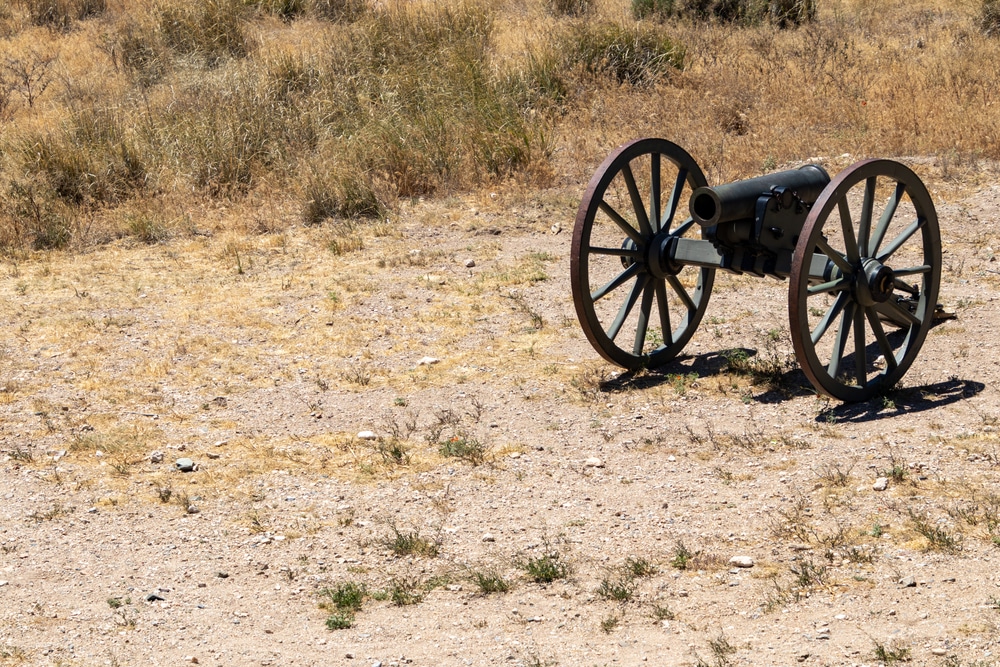
The primary way to access Fort Bowie is via a moderate 1.5-mile hike through a desert canyon, beginning at the trailhead off Apache Pass Road. Along the trail, you’ll encounter:
The remains of a Butterfield Stage Coach station
Apache Spring, a vital water source for both the Apache and the U.S. Army
A pioneer cemetery, with the graves of soldiers, settlers, and Apaches
Interpretive signs along the trail provide historical context, making the journey part of the Fort Bowie experience—not just the destination.
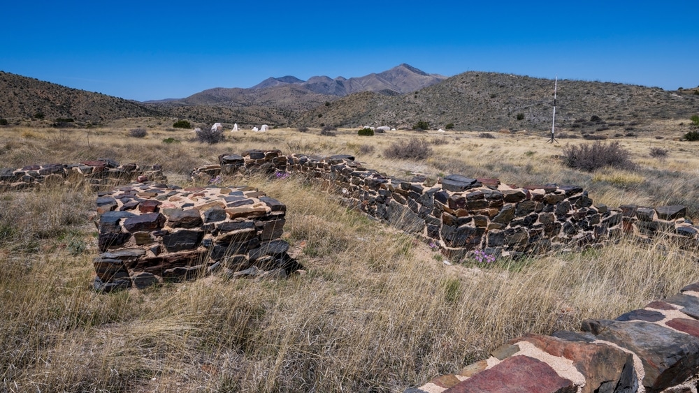
At the end of the trail, you’ll arrive at the ruins of the second Fort Bowie, constructed in 1868 and used until it was decommissioned in 1894. You can walk among the foundations of officers’ quarters, barracks, the bakery, and the commanding officer’s home. The peaceful desert setting contrasts sharply with the fort’s violent history, creating a powerful sense of reflection.

Located near the fort ruins, the Fort Bowie Visitor Center features:
Exhibits on the Apache Wars, including the conflicts with leaders like Cochise and Geronimo
Artifacts from the fort’s military occupation
Insights into daily life for soldiers and their families stationed at this remote post
Park rangers are available to answer questions, and there’s a small bookstore for maps and educational materials.

Near the fort and visitor center are picnic tables and shaded areas, ideal for resting after your hike and enjoying a quiet lunch while overlooking the ruins and the surrounding desert.

This historically significant mountain pass was used by the Butterfield Overland Mail and served as a key route for Apache, Spanish explorers, settlers, and soldiers. The strategic importance of Apache Pass led to the placement of Fort Bowie nearby. Today, you can drive portions of the old route and stand where history was made.

Fort Bowie lies in a transition zone between desert and grassland, making it a diverse habitat for wildlife. You may see:
Deer, coyotes, and javelinas
Desert reptiles like horned lizards
Birds such as canyon wrens, hummingbirds, and raptors
Bring binoculars and a camera, especially during early morning or late afternoon hours.

Photographers will appreciate the stunning desert vistas, rolling hills, and historical structures. The ruins at sunrise or sunset, backlit by golden light, create striking imagery, while the springtime desert bloom adds seasonal color.

Due to its remote location and low light pollution, Fort Bowie is an excellent location for nighttime stargazing. After sunset, the skies come alive with stars, constellations, and the occasional Milky Way view. While overnight stays aren’t allowed in the park, nearby public lands can provide camping options.
| Category | Details |
|---|---|
| Name | Fort Bowie, Arizona |
| Type | Former military fort / preserved historic site |
| County | Cochise County |
| Founded | 1862 (Camp Bowie); 1868 (Fort Bowie established) |
| Status | Abandoned in 1894; preserved as a National Historic Site |
| Population (Historic) | Small military garrison (~100–200 troops and support staff) |
| Population (Current) | None |
| Historical Significance | Central to the Apache Wars, especially conflict with Chiricahua Apache leader Geronimo |
| Named After | Colonel George Washington Bowie, California Volunteers |
| Military Use | Protected settlers, mail routes, and enforced reservation policies |
| Notable Events | Site of Bascom Affair, Battle of Apache Pass, and Geronimo’s surrender efforts |
| Post Abandonment | Decommissioned in 1894 as Indian conflicts subsided |
| Preservation Status | Managed by National Park Service; features ruins, cemetery, visitor center |
| Remnants Today | Adobe walls, barracks ruins, fort cemetery, wagon trails, interpretive signage |
| Geographic Setting | Located in Apache Pass, between the Dos Cabezas and Chiricahua Mountains |
| Access | Hiking trail (~1.5 miles each way) from trailhead off AZ Highway 186 |
| Elevation | Approx. 5,000 feet (1,524 meters) |
| Climate | Semi-arid high desert — hot summers, chilly winters |
| Best For | Military and Native American history enthusiasts, hikers, heritage tourists |
| Managed By | National Park Service – Fort Bowie National Historic Site |
Fort Bowie emerged from the blood-soaked soil of Apache Pass in July 1862, following the Battle of Apache Pass, in which California Volunteers under General James Carleton encountered fierce resistance from Chiricahua Apache warriors led by Cochise and Mangas Coloradas. The battle crystallized American military concerns about securing this crucial mountain passage, which contained vital springs and commanded the route between the Rio Grande and the Colorado River.
Named after Colonel George Washington Bowie, commander of the 5th California Volunteer Infantry, the fort began as a crude field entrenchment before evolving into a permanent installation. Its establishment represented the strategic importance the U.S. government placed on controlling transportation corridors through the newly created Arizona Territory, split from New Mexico Territory in 1863.
The fort’s primary purpose was threefold: to protect the Butterfield Overland Mail route (and later the stagecoach routes that succeeded it), to secure water sources necessary for desert travel, and to serve as a base of operations against Apache resistance to American encroachment. This last objective would define Fort Bowie’s purpose for most of its existence, as it became headquarters for campaigns against Cochise, Victorio, Naiches, and most famously, Geronimo.
At its peak in the 1880s, Fort Bowie housed approximately 150 soldiers plus officers, creating a small but significant community in this remote corner of the territory. The fort’s population fluctuated with military campaigns and national policy shifts, growing during periods of heightened conflict and contracting during more peaceful intervals. A small civilian community of sutlers, laundresses, freighters, and others serving the military population developed alongside the fort, eventually including a stage station, mail facilities, and modest commercial establishments.
Fort Bowie’s history unfolded against the backdrop of America’s post-Civil War expansion, incorporating many of the tensions and policies of that era. Many of its commanders and troops were Civil War veterans, bringing eastern military traditions and perspectives to this southwestern outpost. The fort represented the application of federal power in consolidating the nation’s territorial claims, often at the expense of indigenous populations who had controlled these lands for centuries.
The fort was tied to several pivotal moments in Arizona history, including the 1872 peace between General Oliver O. Howard and Cochise, made in the nearby Dragoon Mountains, which temporarily reduced hostilities, and the final surrender of Geronimo in 1886, after which he was brought to Fort Bowie before being sent east by rail. These events transformed Fort Bowie from a remote outpost to a place of significant historical consequence in the development of the American Southwest.
Today, Fort Bowie exists as a preserved archaeological site within the Fort Bowie National Historic Site, managed by the National Park Service since 1964. Unlike many ghost towns that have succumbed entirely to the elements, Fort Bowie’s ruins have benefited from professional stabilization and preservation efforts, allowing visitors to discern the outlines and purpose of many structures.
The fort’s remains occupy two adjacent areas representing its evolution: “First Fort Bowie,” the original temporary post established in 1862, and “Second Fort Bowie,” the more substantial, permanent installation constructed beginning in 1868. The first fort’s footprint is marked primarily by foundation stones and interpretive signage, while the second fort presents more substantial ruins.
At the second fort site, visitors can identify the parade ground—a large rectangular space forming the heart of the military complex—surrounded by building foundations. The commanding officer’s quarters, officers’ row, barracks, guardhouse, hospital, commissary, and quartermaster’s storehouse are all visible as stone foundations with portions of walls still standing. The most substantial remaining structure is the fort’s corrals and stables, where stone walls still reach several feet high.
Near the parade ground, the sutler’s store foundation illustrates the civilian commercial presence that supported military operations. The remains of a small schoolhouse, established for the children of officers and civilian employees, stands as a reminder of the community life that developed at this remote outpost.
The fort’s infrastructure is evident in the remnants of the water system, including sections of the pipeline that carried water from Apache Spring to the fort complex. Traces of the small dam built to improve water collection can still be seen at the spring site, along with the ruins of the pump house that once contained steam engines to move water uphill to the fort.
Unlike many Arizona ghost towns subjected to looting and vandalism, Fort Bowie’s status as a National Historic Site has ensured that artifacts remain protected in situ or are properly curated at the small visitor center near the ruins. Archaeological excavations have revealed thousands of objects that illuminate daily life at the fort, from military equipment and uniform buttons to personal items and household goods.
The site is accessible via a 1.5-mile interpretive trail that begins at a small parking area off Apache Pass Road. This moderately difficult hike, which follows historic routes and passes by Apache Spring and the cemetery, is the only public access to the ruins. This approach has preserved the site’s remote character while limiting vehicular impact. A small visitor center at the fort site houses exhibits, though facilities are minimal, reinforcing the isolated frontier experience.
A half-mile from the main fort ruins, the Fort Bowie Cemetery rests on a gentle slope overlooking Apache Pass, a solemn counterpoint to the military and civilian structures. By the time the fort closed in 1894, the cemetery may have held as many as 112 graves.
The cemetery predates the fort itself. Its first burials were three privates of the California Column killed by Apaches, foreshadowing the conflicts that would define the region for decades.
The cemetery’s gravestones tell a stark story of frontier life and its dangers. Military markers predominate, their standard government-issue stones bearing minimal information—name, rank, unit, and date of death. Causes of death, when known, reveal the diverse threats facing soldiers at this remote post: Apache attacks, accidents, disease, and in a few cases, violence between soldiers. Several stones bear the word “Unknown,” marking the graves of individuals—likely civilians or scouts—whose identities were lost to history.
The arrangement of graves reflects military hierarchy and period burial customs, with officers’ plots separated from enlisted men. The cemetery also includes graves of civilian employees, including sutlers (military merchants), teamsters who operated supply wagons, and at least one female laundress. Several children’s graves—tiny monuments bearing testimony to the harsh conditions of frontier life—cluster in one section, victims of childhood diseases exacerbated by isolation from medical facilities.
The cemetery remained in use even after the fort was abandoned in October 1894. Most burials were later removed, and only between 23 and 33 bodies are thought to remain.
Today, the cemetery is preserved as part of the National Historic Site, with restoration work conducted on damaged markers. The harsh desert environment has weathered many inscriptions to near illegibility, while some markers bear the marks of earlier vandalism from the period before formal protection. The National Park Service maintains detailed records of known burials, preserving information that is slowly disappearing from the physical markers.
While Fort Bowie never supported its own newspaper, the post and its surrounding community featured prominently in several territorial publications that documented life at this significant frontier outpost.
Most consistent coverage came from the Tucson publications, as Fort Bowie fell within their regional circulation area. Beginning in the 1870s, these papers regularly published dispatches from military officers or civilian employees detailing Apache activities, troop movements, and significant events. During periods of heightened conflict, such as Geronimo’s final campaigns in the mid-1880s, Fort Bowie often dominated front pages across the territory.
These newspapers framed Fort Bowie according to their editorial positions, which generally favored aggressive military action against the Apaches.
The newspapers documented the rhythms of fort life beyond military campaigns—dances and social events, visits from dignitaries, improvements to facilities, and even sports competitions between military units. These glimpses into daily life provide historical texture often absent from official military reports.
Civilian businesses at Fort Bowie advertised in regional newspapers, particularly the stage station and merchants who served both military personnel and travelers. These advertisements provide evidence of commercial networks that connected the isolated outpost to territorial commerce.
The most significant journalistic coverage of Fort Bowie came during Geronimo’s final surrender in 1886, when reporters from national publications including Harper’s Weekly and the New York Herald joined territorial journalists to document this historic conclusion to the Apache Wars. These reports, though often sensationalized, elevated Fort Bowie’s profile in national consciousness and preserved crucial firsthand accounts of this pivotal moment.
Today, these newspaper accounts, preserved on microfilm at the Arizona Historical Society and in digital archives of the Library of Congress, provide essential primary sources for understanding Fort Bowie’s significance in territorial Arizona. They capture contemporary perspectives on events now viewed through very different historical lenses, revealing how Fort Bowie was understood by those who experienced its active years.
Fort Bowie’s relationship with transportation networks significantly influenced both its establishment and eventual obsolescence. Initially positioned to protect the Butterfield Overland Mail route that traversed Apache Pass, the fort’s strategic value evolved as transportation technology transformed the American Southwest.
The Butterfield route, established in 1858, represented the first regular mail and passenger service connecting California with the eastern United States. This stagecoach line followed a southern route through Apache Pass specifically because the mountain spring provided reliable water essential for desert crossing. When Cochise’s Chiricahua Apaches began restricting access to this critical water source following a series of cultural misunderstandings and violent confrontations, the resulting disruption to this vital communication link prompted military intervention and ultimately the fort’s establishment.
The fort maintained its own transportation infrastructure, including corrals, wagon yards, and blacksmith shops that supported military freight operations. Supply wagons from Tucson regularly made the long trip to Fort Bowie, bringing provisions and connecting the isolated post to regional commerce. The military improved and maintained the wagon road through Apache Pass, constructing drainage culverts and grading difficult sections to ensure reliable access.
The arrival of the Southern Pacific Railroad in southeastern Arizona in 1880 transformed the fort’s connectivity. Though the main line passed about 13 miles north of Fort Bowie at Bowie Station (originally called Teviston), this rail connection dramatically improved supply logistics. The military constructed a wagon road from the fort to the rail station, and by 1881, most heavy supplies arrived via this route rather than the longer journey from Tucson.
The railroad’s impact extended beyond logistics, fundamentally altering the fort’s strategic relevance. The speed and volume of rail transport enabled more rapid military response from centralized bases, reducing the need for isolated outposts like Fort Bowie.
After Geronimo’s surrender in 1886, the fort’s transportation significance steadily diminished. By the time of its decommissioning in 1894, the railroad had thoroughly reconfigured regional transportation patterns. The former stage routes through Apache Pass declined in importance as rail-centered communities like Willcox and Bowie overshadowed the once-vital mountain passage.
Today, visitors to Fort Bowie can trace these transportation legacies in the remains of wagon roads, the stage station foundations, and interpretive materials that explain how changing transportation technologies both created and ultimately rendered obsolete this significant military outpost.
Fort Bowie’s decline began shortly after achieving its primary objective—the end of Apache resistance in southeastern Arizona. Following Geronimo’s surrender in 1886, the fort that had served as headquarters for the campaign against him rapidly lost strategic significance. The pattern of obsolescence that followed illustrated the changing military priorities of the United States as it transitioned from Indian Wars to new geopolitical concerns.
The changing transportation landscape accelerated the fort’s decline. As railroad networks expanded throughout Arizona Territory, the military increasingly favored posts with direct rail connections for rapid troop movement and supply efficiency. Fort Bowie’s relative isolation, once considered an asset for controlling Apache Pass, became a logistical liability.
The Army abandoned Fort Bowie in October 1894, and its adobe walls were left to erode.
The remoteness that once made Fort Bowie strategically valuable now contributed to its preservation. Unlike many historic sites subjected to intensive looting or stone repurposing, Fort Bowie remained relatively undisturbed due to difficult access. This neglected status paradoxically protected the archaeological integrity that would later make it valuable for historical preservation.
Fort Bowie occupies a pivotal place in Southwestern history as the epicenter of the decades-long conflict between the United States and the Chiricahua Apaches. Its cultural and historical significance extends beyond its military function, embodying the collision of disparate civilizations and the transformation of the American frontier.
As a military installation, Fort Bowie represented the application of federal power in the newly acquired territories following the Gadsden Purchase. Military historians recognize it as exemplifying the evolution of frontier defenses from temporary field fortifications to permanent installations capable of projecting power across vast territories. The fort’s architectural development—from crude earthworks to a proper military post—paralleled the broader expansion of American military infrastructure throughout the West.
For Apache history, Fort Bowie symbolizes both resistance and capitulation. The fort stands on ground sacred to the Chiricahua, near springs that sustained their people for generations before becoming contested space. Cochise, whose name became synonymous with Apache resistance, made the 1872 peace with General Howard in the nearby Dragoon Mountains. Geronimo’s final surrender at Skeleton Canyon in 1886 marked the effective end of armed indigenous resistance in the Southwest. Contemporary Apache communities maintain cultural connections to this site, considering it part of their heritage landscape despite its associations with defeat.
Archaeological studies conducted since the 1960s have documented Fort Bowie’s significance for understanding daily life on the frontier. These materials have enabled detailed analysis of supply systems, consumption patterns, and material adaptations to frontier conditions, contributing significantly to historical archaeology of the American West.
The fort received its first formal recognition in 1960 when designated a National Historic Landmark, acknowledging its exceptional value in illustrating American history. This designation focused primarily on the fort’s military significance, particularly its role in the Apache Wars. The establishment of Fort Bowie National Historic Site in 1964 expanded this recognition to encompass the broader historical landscape, including civilian components and indigenous perspectives.
For Cochise County tourism and economic development, Fort Bowie represents a tangible connection to the region’s frontier history that attracts visitors interested in Western history. Though less accessible than nearby attractions like Tombstone, the fort draws visitors who contribute to the local economy. Its remote location and preserved condition offer an authentic historical experience increasingly rare in more commercially developed historic sites.
Educational programs at Fort Bowie, developed in collaboration between the National Park Service and regional schools, utilize the site to teach multiple perspectives on Western expansion. These programs have evolved significantly since the site’s establishment, increasingly incorporating indigenous viewpoints alongside military history.
The fort’s significance extends to environmental history as the protection of the historic site has preserved approximately 1,000 acres of relatively undisturbed Chihuahuan Desert ecosystem. This protected status has enabled ecological research on desert watershed systems and native plant communities, creating a living laboratory where natural and cultural resources intersect.
In the broader narrative of American history, Fort Bowie illustrates the complex legacy of Manifest Destiny—both the triumphal story of national expansion and the sobering reality of displacement and cultural disruption. As historical perspectives have evolved, Fort Bowie has become a place where multiple interpretations of the past can be examined, challenging simplified narratives of “winning the West” while acknowledging the genuine struggles and sacrifices of all peoples connected to this contested ground.
The Fort Bowie post cemetery has received varying levels of preservation and commemorative attention, reflecting broader patterns in how different aspects of frontier history are valued and remembered.
Conservation challenges at the cemetery stem primarily from environmental factors. The extreme temperature fluctuations of the Chihuahuan Desert—often exceeding 50 degrees Fahrenheit within a single day—accelerate stone deterioration through expansion and contraction. Monsoon erosion threatens grave outlines, while alkaline soil conditions affect buried materials. The National Park Service maintains a monitoring program that documents these ongoing threats, implementing mitigation measures including carefully designed drainage systems and selective application of preservation treatments to vulnerable stones.
Descendants of military personnel buried at Fort Bowie occasionally visit to conduct private commemorations, leaving traditional military tributes such as coins or small flags on ancestors’ graves.
The National Park Service has established policies that respect these diverse memorial practices while ensuring preservation of the cemetery’s historical character. Guidelines permit temporary commemorative items while prohibiting permanent alterations to the historical landscape. This balanced approach treats the cemetery as both a historical resource and a place of remembrance.
Fort Bowie National Historic Site welcomes visitors while emphasizing responsible engagement with this significant historical landscape. The site’s remote location and limited development preserve its historical character but require thoughtful preparation from those wishing to experience this frontier outpost.
Access to Fort Bowie requires a moderate 1.5-mile hike from the parking area on Apache Pass Road, a design decision made deliberately during site planning to maintain the fort’s isolated atmosphere and minimize development impacts. This trail follows the historic road to the fort, passing key sites including Apache Spring, the Butterfield Stage Station ruins, and the military cemetery before reaching the main fort ruins. Visitors with mobility limitations can arrange special access by contacting the National Park Service in advance.
The National Park Service maintains minimal facilities at the fort site, including a small visitor center with exhibits, restrooms, and water fountains. No food services or overnight accommodations exist within the historic site. Visitors should bring adequate water, sun protection, and appropriate footwear for desert hiking. The nearest services are in Bowie, about 13 miles north of the trailhead, and in Willcox.
Ethical visitation of the cemetery requires particular sensitivity. Park Service guidelines request that visitors remain on designated paths around the burial areas and refrain from touching or leaning on grave markers, as the weathered stone is increasingly fragile. Photography for personal use is permitted, but rubbings or other direct contact with headstones is prohibited to prevent further deterioration.
Archaeological resources at Fort Bowie remain vulnerable despite protected status. Visitors are reminded that removal of any artifacts, including seemingly insignificant items like nails or pottery fragments, is prohibited by federal law and diminishes the site’s historical integrity. The “leave no trace” principle applies equally to human impacts on both cultural and natural resources.
The site’s remote location presents safety considerations beyond typical national park visits. Cell phone service is nonexistent throughout Apache Pass, and summer temperatures frequently exceed 100 degrees Fahrenheit. Winter visitors occasionally encounter snow at this 5,000-foot elevation. The visitor center is staffed during operating hours, but assistance may be distant in emergencies.
Fort Bowie represents sacred space for Apache communities, particularly the Chiricahua descendants now living in Oklahoma and New Mexico. Visitors may occasionally encounter tribal members conducting private ceremonies or leaving traditional offerings. The National Park Service requests that such activities be observed respectfully from a distance, without photography or interruption.
Interpretive programs at Fort Bowie have evolved to present multiple perspectives on this complex history. Rangers and educational materials now acknowledge both military and Apache viewpoints, moving beyond earlier narratives that presented only the U.S. military perspective. Visitors are encouraged to consider the site from various historical vantage points, including those of the Apache people defending their homeland, soldiers following government orders, and civilians caught between conflicting forces.
For those unable to visit in person, the Fort Bowie National Historic Site website offers virtual tours and extensive historical information. The Western Archeological and Conservation Center in Tucson maintains the archaeological collection from Fort Bowie, with selected artifacts available for research purposes with advance arrangement.
As the sun sets over the Chiricahua Mountains, casting long shadows across the ruins of Fort Bowie, the weight of history seems palpable in the desert air. This remote outpost, once the epicenter of one of America’s longest and most complex frontier conflicts, now stands in silent testimony to the impermanence of military power and the enduring significance of contested places.
The weathered stone foundations, the simple military cemetery, and the vanished newspaper accounts and transportation networks that once animated this place all speak to different dimensions of a shared past. Fort Bowie represents neither simple conquest nor straightforward resistance, but rather the messy, complicated reality of cultural collision on a contested frontier.
What makes Fort Bowie particularly valuable in understanding Western history is its preservation as a landscape rather than merely a collection of buildings. Here, visitors can trace the routes of soldiers and Apaches, see the vital spring that made this mountain pass strategically crucial, and understand how geography shaped human conflict and cooperation. The fort’s ruins, rather than restored to artificial perfection, honestly reflect the passage of time and the ultimate transience of even our most substantial endeavors.
For the descendants of those who lived and died here—whether Apache fighters defending ancestral lands, soldiers serving a distant government, or civilians seeking opportunity in a dangerous borderland—Fort Bowie remains a place of complex memory. The post cemetery, with its weathered markers slowly returning to the earth, reminds us of the human cost of empire-building and resistance, while challenging simplistic narratives of heroes and villains.
Perhaps the most important lesson of Fort Bowie lies in what followed its abandonment. The military post that once represented American determination to control this land ultimately proved temporary, while the relationships between peoples and landscapes continue to evolve. The Apache people, though removed from their homeland during the fort’s operation, maintain cultural connections to this place across generations and geography. The descendants of soldiers and settlers have likewise developed complex relationships with this difficult history.
As we stand among these ruins today, we might consider how our own certainties and structures may appear to future generations. Fort Bowie reminds us that what seems permanent in one historical moment may become artifact in the next, yet the stories we tell about such places continue to shape our understanding of who we are and how we came to be. In preserving this ghost town and its cemeteries, we preserve not just stone and soil but the opportunity to continually reexamine our shared and contested past.
Historical photographs used in research for this article courtesy of:
We use cookies to improve your experience on our site. By using our site, you consent to cookies.
Manage your cookie preferences below:
Essential cookies enable basic functions and are necessary for the proper function of the website.
Statistics cookies collect information anonymously. This information helps us understand how visitors use our website.
Monetize your website by displaying targeted ads and earning revenue from clicks and impressions.
Google Analytics is a powerful tool that tracks and analyzes website traffic for informed marketing decisions.
Service URL: policies.google.com (opens in a new window)
You can find more information about our Cookie Policy and Privacy Policy.


