As the late afternoon sun casts long shadows across the arid landscape, the remnants of Cibola, Arizona stand in quiet testimony to a bygone era. Here, along the eastern banks of the Colorado River in southwestern Arizona, time seems to have slowed to a crawl. Wind whistles through abandoned structures, carrying whispers of a once-thriving community that carved out an existence in this challenging desert frontier. Among the scattered remnants, the Bishop Family Cemetery stands as a solemn sentinel—a final resting place for the pioneers who dared to dream of prosperity in this remote corner of the Arizona Territory.
Situated near the Colorado River, Cibola existed as more than just another settlement; it represented the tenacious spirit of Western expansion, with its fortunes tied to the river, agriculture, and the connections that would eventually be forged through newspapers and railroads. Today, the small Bishop Family Cemetery serves as one of the few tangible links to this vanished community, offering silent testimony to the lives, struggles, and aspirations of those who came before. Through these weathered gravestones and forgotten pathways, we can glimpse the rich tapestry of Arizona’s pioneer past and the impermanence of human endeavors against the backdrop of the enduring desert.
While birding takes center stage, Cibola is also home to desert mule deer, coyotes, bobcats, jackrabbits, and reptiles like desert tortoises and lizards. Keep a respectful distance, and you might witness quiet interactions between species as they gather near water sources or roam the refuge’s desert edges.
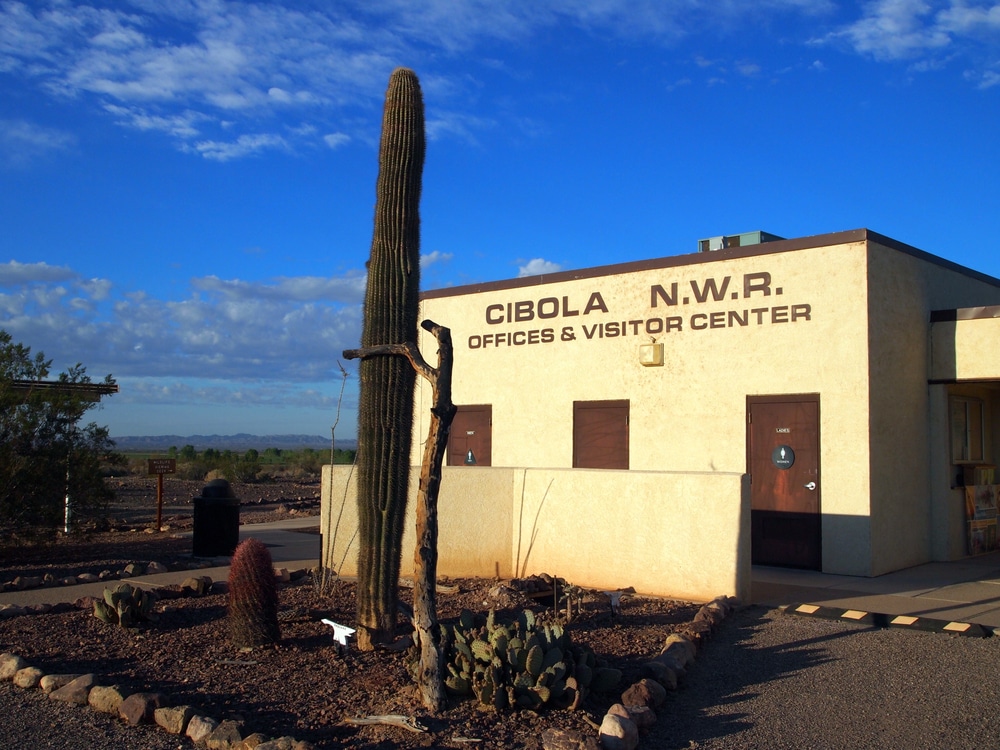
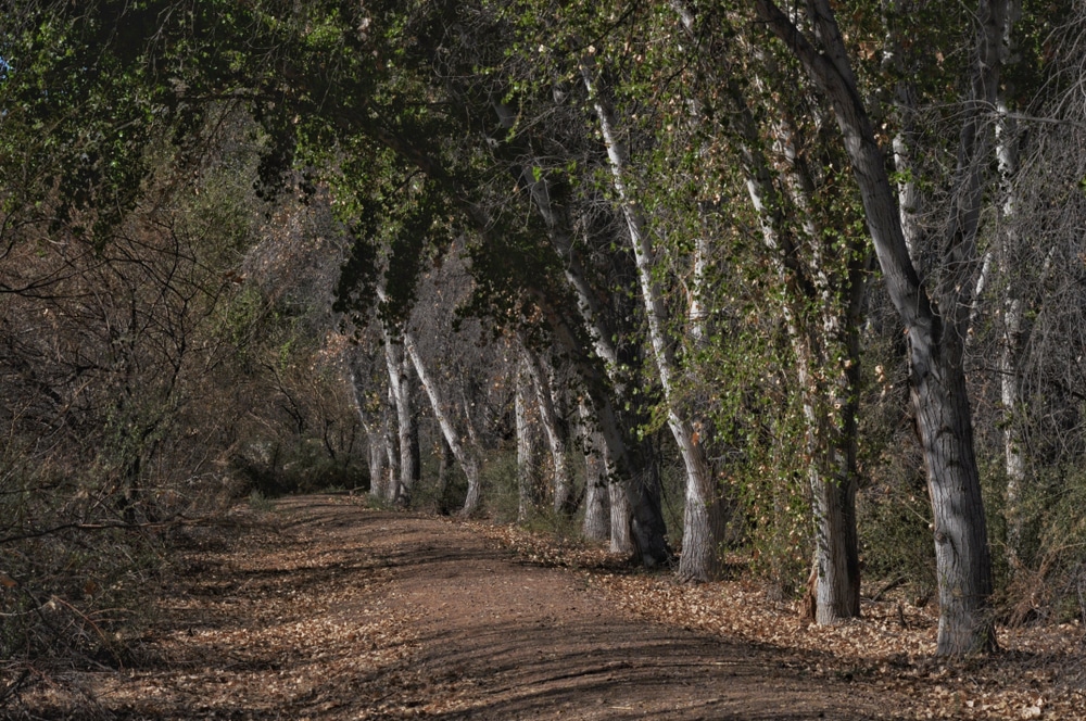
The crown jewel of the area is the Cibola National Wildlife Refuge, a protected oasis that supports an abundance of wildlife in the lower Colorado River Valley. The refuge spans over 16,000 acres and is known for its incredible birdwatching, especially during winter migration when thousands of sandhill cranes, snow geese, and other waterfowl arrive. Nature trails like the Canada Goose Loop and Cornfield Nature Trail offer accessible ways to explore riparian woodlands, wetlands, and desert uplands teeming with life.

Cibola offers primitive camping on surrounding BLM (Bureau of Land Management) land and designated campgrounds in the refuge area. Visitors often set up RVs or tents along the riverbanks, enjoying the open sky, quiet nights, and access to fishing or paddling. Facilities are minimal, so it’s essential to bring your own water, supplies, and waste disposal materials.

The nearby Colorado River provides opportunities for recreational boating, kayaking, and canoeing in peaceful, scenic surroundings. Anglers can fish for catfish, bass, bluegill, and carp in the backwaters and sloughs near Cibola. With limited boat traffic and beautiful desert-mountain backdrops, it’s a perfect spot for relaxed water recreation.

The mix of river, wetland, farmland, and desert offers an exceptional canvas for photographers and artists. Whether capturing a hawk in flight, a golden-lit mountain range, or a mirror-still pond reflecting cottonwood trees, Cibola’s light and landscape inspire creativity.

Cibola is one of Arizona’s premier birdwatching destinations. More than 288 species of birds have been recorded here, including bald eagles, great blue herons, egrets, hawks, and numerous migratory songbirds. Photographers and nature lovers can spend hours along the refuge trails or observation decks, capturing stunning images of animals in their natural habitat.

The drive into Cibola along the River Road (Cibola Road from Ehrenberg) takes travelers through serene desert terrain and agricultural fields, offering a glimpse into Arizona’s rural heartland. This scenic route is especially beautiful in the early morning or late afternoon, when the light casts a golden hue over the landscape.
With minimal light pollution, Cibola offers outstanding stargazing. On a clear night, visitors can enjoy sweeping views of the Milky Way, meteor showers, and constellations. Stargazing here is best enjoyed during the cooler months or on moonless nights for maximum clarity.
Among the silent residents of the Bishop Family Cemetery, several life stories stand out, providing windows into Cibola’s human experience. Charles Bishop, the family patriarch, left a detailed journal (preserved by descendants and now housed in the Arizona Historical Society archives) chronicling his journey from Iowa to Arizona in 1882 and the challenges of establishing agriculture in the desert environment. His entries reveal both determination and occasional despair, particularly during a devastating flood in 1891 that destroyed much of that year’s crops and threatened to undo nearly a decade of work building irrigation systems.
Emily Bishop’s grave, marked by one of the cemetery’s most elaborate headstones, tells another compelling story. Local history recounts that Emily served as an informal medical practitioner for the community, using knowledge of both traditional and Native American herbal remedies to treat everything from fevers to childbirth complications. Her obituary in The Yuma Sun noted that “settlers from miles around sought Mrs. Bishop’s healing touch,” and that she had reportedly delivered more than thirty children in the Colorado River communities.
One of the most poignant stories belongs to Miguel Vasquez (1873-1918), whose simple grave marker belies his significant contributions to Cibola’s agricultural development. Arriving from Sonora as a laborer, Vasquez eventually developed an innovative irrigation technique that helped local farmers conserve water during drought periods. Though never wealthy, his funeral was reportedly attended by nearly everyone in the community, demonstrating the respect he had earned across cultural boundaries.
The grave of Mei Chen (approximate dates 1860-1915), one of the few Chinese residents recorded in Cibola, represents another dimension of Western settlement often overlooked in pioneer narratives. Oral histories suggest Chen operated a small laundry service and later worked as a cook for the Bishop family. His presence indicates the diverse contributions to community building that extended beyond the dominant narrative of white settlement.
Perhaps most touching are the small graves of the Bishop children—three markers for infants who died between 1894 and 1900. Their simple stones, decorated with lamb motifs symbolizing innocence, testify to the harsh realities of childhood mortality on the frontier, where medical care was limited and diseases that are easily treatable today claimed many young lives.
| Category | Details |
|---|---|
| Name | Cibola, Arizona |
| Type | Rural unincorporated community (not a ghost town) |
| County | La Paz County (formerly Yuma County) |
| Founded | 20th century as a modern agricultural and river-access community |
| Status | Active; small population |
| Population (Current) | ~200 (2020 U.S. Census) |
| Historical Significance | Named after the legendary “Seven Cities of Cibola” sought by Spanish explorers |
| Nearby Historical Context | Area inhabited by Native peoples; visited by early Spanish expeditions |
| Primary Economy | Agriculture, seasonal tourism, river recreation |
| Nearby Features | Cibola National Wildlife Refuge, Colorado River, border with California |
| Remnants Today | No historic ruins; site is active and modern |
| Access | Via rural roads from Ehrenberg or Blythe, CA; off the beaten path |
| Elevation | Approx. 250 feet (76 meters) |
| Climate | Hot desert – extremely hot summers, mild winters |
| Best For | Birdwatching, kayaking, RV camping, off-grid exploration |
Cibola’s origins are tied to the lifeline of the Southwest—the Colorado River. The name “Cibola” itself carries historical weight, echoing the legendary “Seven Cities of Cibola” that Spanish explorers sought in the 16th century, chasing tales of gold and riches. While the mythical cities of gold never materialized, the real Cibola emerged in the late 19th century as settlers recognized the agricultural potential of the Colorado River Valley.
The settlement took formal shape in the 1880s when hardy pioneers, including the Bishop family, established farms and ranches along the fertile riverbanks. Unlike many Arizona boom towns driven by mining, Cibola’s economy centered primarily on agriculture, with farmers cultivating the rich alluvial soil deposited by the river’s seasonal floods. Cotton, alfalfa, and various food crops thrived in the desert heat when properly irrigated with Colorado River water.
While never achieving the dramatic population booms of mining communities, Cibola maintained a stable community of perhaps several hundred residents at its peak in the early 1900s. The Bishop family, for whom the cemetery is named, were among the most prominent early settlers, establishing extensive agricultural operations and becoming central figures in community development.
Cibola’s history parallels the broader story of Western expansion, representing the agricultural frontier rather than the more celebrated mining or cattle frontiers. This phase of Arizona’s development was crucial, as these farming communities helped feed the growing population in more specialized towns focused on resource extraction or transportation.
The community weathered significant challenges, including devastating floods of the unpredictable Colorado River, periodic droughts, and the economic hardships that afflicted rural America in the late 19th and early 20th centuries. The Great Depression and changes in agricultural economics would eventually contribute to Cibola’s decline, but for decades, the small community persevered through determination and adaptation.
Today, little remains of Cibola’s former presence along the Colorado River. Nature has reclaimed much of what humans built, with only scattered foundations, the occasional weathered wooden structure, and irrigation remnants hinting at the community that once thrived here. The harsh desert environment has accelerated the decay process, with summer temperatures regularly exceeding 110°F (43°C) degrading wood, adobe, and other building materials.
The most visible remnants include portions of old irrigation canals, now mostly filled with sand and desert vegetation, that once diverted life-giving water from the Colorado River to the surrounding fields. A few crumbling adobe walls stand as testament to the typical construction methods employed by settlers adapting to the desert climate—thick walls providing natural insulation against the extreme temperatures.
The layout of the former town can still be partially discerned by careful observers, with faint traces of main roadways visible from elevated vantage points. Former agricultural fields, now returned to desert scrub, sometimes reveal their past purpose through subtly different vegetation patterns or the geometric remains of irrigation systems.
Unlike some of Arizona’s more famous ghost towns, Cibola has not benefited from preservation efforts or tourism development. Its remote location and relatively modest remaining structures have kept it from becoming a major historical attraction. Access requires determination, with rough dirt roads leading to the site, and visitors are few and far between.
For those who do make the journey, the site offers an authentic, if subtle, connection to Arizona’s agricultural pioneer past—one unembellished by tourist amenities or reconstructed buildings. The Bishop Family Cemetery remains the most intact historical feature, anchoring the location to its human history in a landscape that otherwise seems determined to erase the evidence of settlement.
The Bishop Family Cemetery sits on a small rise overlooking what was once the heart of Cibola, providing a permanent vantage point for the departed to watch over the lands they worked to cultivate. Enclosed by a simple iron fence—repairs to which indicate some ongoing maintenance—the cemetery occupies less than an acre of sun-baked earth dotted with creosote bushes and occasional wildflowers after rare rainfall.
The cemetery dates primarily from the 1880s through the 1940s, with the earliest marked grave belonging to Emily Bishop (1834-1889), matriarch of the founding Bishop family. Approximately two dozen visible grave markers remain, though weather and time have rendered some inscriptions illegible. The markers range from simple wooden crosses (few of which have survived intact) to more substantial sandstone and marble headstones for more prominent community members.
Several graves bear witness to the harsh realities of frontier life, with numerous infant and child burials speaking to the high childhood mortality rates of the era. The clustering of several deaths in 1905 suggests a possible localized disease outbreak, though records are insufficient to confirm the specific cause.
The Bishop family plot occupies the cemetery’s center, with three generations represented. The most elaborate marker belongs to Charles Bishop (1830-1902), a Civil War veteran who led the family’s migration to Arizona and established their agricultural holdings. His stone includes Masonic symbols, indicating his membership in that fraternal organization and suggesting community connections beyond Cibola itself.
Weathering poses a significant threat to the remaining grave markers, with sandstone monuments particularly vulnerable to erosion from occasional flash floods and constant wind. The cemetery’s remote location has protected it from vandalism, but has also limited regular maintenance, resulting in a site that feels authentic in its aging but increasingly vulnerable to the elements.
Unlike many larger settlements, Cibola appears not to have maintained separate pioneer and community cemeteries. The Bishop Family Cemetery served as the primary burial ground for the entire settlement, though its name reflects the prominence of the founding family and their ownership of the land on which it sits.
Records and remaining markers indicate that the cemetery served a relatively diverse community for a rural Arizona settlement of its era. In addition to the predominantly Anglo-American homesteaders, several Hispanic surnames appear on markers, reflecting the cultural connections to nearby Mexican communities and the broader heritage of the Colorado River region. At least two graves with Chinese inscriptions likely belong to laborers who worked on irrigation projects or as domestic staff for wealthier families.
Burial customs evolved subtly over the cemetery’s active period, with earlier graves featuring more religious symbolism and biblical verses, while later markers (from the 1920s onward) adopted more secular and modernized designs. Family groupings remain consistent throughout, emphasizing the close-knit nature of this small farming community.
While formal ceremonies at the cemetery have long since ceased, occasional descendants of Cibola residents still visit to pay respects. Local historians report that until at least the 1970s, informal gatherings of former residents and their families would occur around Memorial Day, though these have dwindled as the direct connections to the community have faded with passing generations.
The small size of Cibola meant it never supported its own dedicated newspaper during its existence. Instead, residents relied on regional publications from larger communities along the Colorado River, particularly The Yuma Sun (established 1870). These newspapers occasionally carried correspondence from Cibola, typically focusing on agricultural conditions, social gatherings, and notable visitors.
The lack of a local newspaper underscores Cibola’s status as a satellite community rather than a major regional center. News from Cibola appeared irregularly in the “County Correspondents” sections of larger papers, with local happenings filtered through the perspective of whatever resident took up the task of reporting to regional editors.
Regional newspaper archives provide some of the few documentary records of daily life in Cibola, capturing snippets of information about harvests, weather conditions, social gatherings, and occasional disputes. The Yuma Sun’s archives, preserved by the Arizona Historical Society, contain sporadic mentions of the Bishop family’s agricultural success and community leadership.
A particularly valuable source comes from a special “Agricultural Edition” published by The Yuma Sun in 1912, which featured a half-page spread on the “Progressive Farms of Cibola Valley,” highlighting the irrigation innovations employed by Charles Bishop’s sons following his death. This edition provides one of the few detailed descriptions of Cibola during its productive years.
The gradual disappearance of Cibola from newspaper mentions through the 1930s and 1940s silently chronicles the community’s decline, with the last significant mention being a brief obituary for Margaret Bishop in 1947, described as “one of the last residents of the once-thriving farming community of Cibola.”
Unlike many Arizona settlements that owed their existence to the railroad, Cibola developed primarily due to its river access. The community never gained direct rail service, which ultimately contributed to its isolation and eventual decline as automobile and rail transportation networks expanded elsewhere in Arizona.
The nearest rail connection was the Southern Pacific line through Yuma, approximately 60 miles to the south. This distance created significant logistical challenges for Cibola farmers attempting to get perishable goods to market. Most agricultural products were initially transported via Colorado River steamboats, which connected to rail lines at Yuma or other river ports.
As river transportation declined in the early 20th century, Cibola’s isolation increased. The lack of rail access meant that goods had to be transported by wagon and later by truck to connect with rail lines, adding expense and complexity that placed Cibola farmers at a competitive disadvantage compared to agricultural areas with direct rail service.
Regional transportation maps from the 1920s show proposed spur lines that would have connected Cibola and other Colorado River communities to the main Southern Pacific route, but these extensions were never constructed as the economic calculus shifted away from small farming communities.
This transportation disadvantage became increasingly problematic as Arizona’s agricultural economy modernized and consolidated through the early 20th century. By the 1930s, the additional costs of getting goods to market from Cibola had rendered many of its agricultural operations economically unviable, accelerating the community’s decline.
Cibola’s decline unfolded gradually rather than resulting from a single catastrophic event. By the 1920s, several factors had begun to undermine the community’s viability. The agricultural depression that preceded the Great Depression hit rural communities like Cibola particularly hard, with falling crop prices making it difficult for small-scale farmers to remain profitable.
Transportation challenges became increasingly problematic as Arizona’s economy modernized. The lack of direct rail access meant Cibola’s farmers faced higher costs getting goods to market than competitors in railroad-connected agricultural areas. The decline of Colorado River shipping as highways and rail networks expanded elsewhere further isolated the community.
Water issues also played a crucial role in Cibola’s fate. The increasing regulation of Colorado River water through the 1922 Colorado River Compact and subsequent agreements gradually reduced the water available for small farming operations. Larger agricultural enterprises with better political connections often secured more favorable water allocations, squeezing out smaller communities like Cibola.
Census records tell the story numerically: from a peak of approximately 300 residents around 1910, Cibola’s population had declined to fewer than 100 by 1930. The Great Depression accelerated this trend, with many families abandoning their farms for opportunities in larger cities. By 1940, only a handful of families remained, primarily older residents with deep ties to the land.
The final chapter for Cibola as a functioning community came in the post-World War II period. The last Bishop family member to reside in the area, Margaret Bishop, died in 1947. Within a few years, the remaining residents had departed, leaving behind their fields, ditches, and buildings to the reclaiming forces of the desert. The Bishop Family Cemetery received its last recorded burial in 1952—James Walker, a former ranch hand who had worked for the Bishop family for over forty years and had no family of his own.
Most former residents relocated to Yuma, Blythe, or Phoenix, where descendants of Cibola families can still be found today. Some maintained ownership of their Cibola lands for decades after leaving, though most properties eventually transferred to federal management as part of wildlife conservation areas or Indian reservation expansions.
Though never among Arizona’s most prominent settlements, Cibola represents an important chapter in the state’s agricultural pioneer history. The community exemplifies the small farming settlements that developed along Arizona’s waterways, providing a counterpoint to the mining camps and railroad towns that often dominate frontier narratives.
The Bishop Family Cemetery was registered with the Arizona State Historic Preservation Office in 1986, providing it with limited protection and recognition. However, no comprehensive archaeological survey of the broader Cibola site has been conducted, leaving much of its physical history undocumented and vulnerable to further degradation.
For the Colorado River Indian Tribes, whose reservation boundaries now encompass some former Cibola lands, the area holds significance as part of their ancestral territory that briefly experienced Euro-American settlement before returning to tribal influence. Tribal historians have expressed interest in collaborative historical work that would document both the pioneer period and the indigenous presence that both preceded and followed it.
From a historical education perspective, Cibola offers an authentic case study in the cycles of Western settlement—the hopeful establishment, brief flourishing, and eventual abandonment that characterized many frontier communities. Unlike ghost towns preserved primarily for tourism, Cibola presents a more typical outcome for many small settlements that simply faded away rather than being frozen in time.
The Bishop Family Cemetery, with its weathered markers and silent testimony, provides one of the few tangible connections to this vanished community. As such, it serves as both a document of individual lives and a monument to the broader patterns of frontier settlement, adaptation, and eventual transition as economic and environmental realities shifted.
The Bishop Family Cemetery exists today in a state of “managed decline” rather than active preservation. Occasional maintenance—primarily clearing of invasive vegetation and fence repairs—is conducted by a loose network of descendants and historical enthusiasts, but no formal conservation plan exists for the site.
Weather represents the greatest threat to the cemetery’s remaining markers, with flash flooding, extreme temperature fluctuations, and wind erosion gradually degrading the more fragile sandstone monuments. Several wooden markers have already been lost entirely, while others have become illegible due to weathering.
Documentation efforts have helped preserve the cemetery’s historical information even as physical markers deteriorate. In the 1970s, members of the Arizona Genealogical Society photographed and transcribed all visible markers, creating a record that captures inscriptions now partially lost to weathering. These records, along with plot maps, are maintained in the society’s archives in Phoenix.
An informal memorial gathering still occurs occasionally at the cemetery, typically organized by Bishop family descendants who maintain connections with their pioneer heritage. These small ceremonies usually coincide with significant anniversaries of Charles Bishop’s arrival in the area or other notable dates in family history.
The cemetery’s remote location has inadvertently contributed to its preservation by limiting casual visitation and potential vandalism. However, this isolation also means that damage from natural causes may go unnoticed for extended periods, and emergency preservation efforts are difficult to coordinate.
For those wishing to visit the Bishop Family Cemetery and Cibola site, respectful approach is essential. The cemetery, while historically significant, represents real lives and contains the remains of pioneers who contributed to Arizona’s development. Visitors should observe standard cemetery etiquette—remaining on pathways, not touching or climbing on monuments, and maintaining a reverent atmosphere.
Access to the area requires preparation. Located on rugged back roads approximately 20 miles north of Ehrenberg, Arizona, the site is best reached with a high-clearance vehicle, abundant water supplies, and navigation equipment. Mobile phone service is unreliable in the area, making self-sufficiency essential for visitors.
No formal permissions are required to visit the cemetery itself, as it remains on public land administered by the Bureau of Land Management. However, some surrounding areas may fall under Colorado River Indian Tribes jurisdiction, requiring tribal permission for access. Checking current land status before visiting is advisable.
Photography for personal or educational purposes is permitted at the cemetery, though commercial photography or any activity that might disturb the site requires permits from the Arizona State Historic Preservation Office. Rubbings of headstones are discouraged due to the fragile condition of many markers.
The Quartzsite Historical Society, located approximately 35 miles south of the site, maintains the most comprehensive local records about Cibola and the Bishop family. Visitors interested in historical context would benefit from consulting their archives before visiting the physical location.
As the sun sets over the Colorado River Valley, the scattered remnants of Cibola and the weathered markers of the Bishop Family Cemetery stand as quiet monuments to the impermanence of human endeavors against the backdrop of the enduring desert. Here, in this remote corner of Arizona, one family’s dream of agricultural prosperity briefly flourished before succumbing to the economic and environmental challenges that reshaped the American West throughout the 20th century.
The story of Cibola reminds us that not all Western settlements followed the romanticized boom-and-bust narrative of mining camps or became the thriving cities along railroad corridors. Many simply faded away as changing conditions rendered their founding purposes obsolete. These quieter disappearances represent a crucial but often overlooked aspect of Western American history—the constant adaptation, movement, and reinvention that characterized frontier communities.
For the pioneers buried in the Bishop Family Cemetery, Cibola represented not just a place but an aspiration—the hope that determination and hard work could transform desert into farmland and create a lasting legacy. While the community itself proved ephemeral, their contributions to Arizona’s agricultural development helped establish patterns and practices that would be refined by later generations of desert farmers.
Preserving sites like the Bishop Family Cemetery provides tangible connections to these pioneers and their stories. Each weathered headstone, each fading inscription represents not just an individual life but a thread in the complex tapestry of Arizona’s development. In protecting these physical remnants, we honor both the specific lives they commemorate and the broader historical patterns they represent.
As modern Arizona continues its rapid transformation, these quiet corners of pioneer history offer valuable perspective on the cyclical nature of human settlement and the relationship between communities and their environments. The whispers of Cibola remind us that today’s thriving developments may someday be tomorrow’s ghost towns—not necessarily through catastrophic failure but through the gradual shifts in economy, technology, and human movement that have always characterized the American West.
Bishop, Charles. “Colorado River Farming: A Pioneer’s Journal, 1882-1902.” Arizona Historical Society Archives, Phoenix.
Colorado River Indian Tribes Cultural Office. “Settlers and Sojourners: Non-Native Communities of the Colorado River Valley, 1850-1950.” Parker, AZ, 2012.
Lingenfelter, Richard. “Steamboats on the Colorado River, 1852-1916.” University of Arizona Press, 1978.
Martinez, Ernesto. “Hispanic Pioneers of the Colorado River Communities.” Journal of Arizona History, vol. 28, no. 3, 1987, pp. 214-236.
Yuma County Historical Society. “Agricultural Communities of the Lower Colorado: Ehrenberg, Cibola, and Poston, 1870-1940.” Yuma, AZ, 1995.
Cemetery photographs courtesy of Arizona State Historic Preservation Office, Survey of Historic Cemeteries Project, 1986-1988. Landscape images by Raymond Thompson, “Ghost Towns of the Colorado River Valley,” Arizona Highways, March 1978.
We use cookies to improve your experience on our site. By using our site, you consent to cookies.
Manage your cookie preferences below:
Essential cookies enable basic functions and are necessary for the proper function of the website.