The sun beats down mercilessly on rusted spikes and weather-worn ties half-buried in the sand, winding like a skeletal serpent through the saguaro-studded landscape east of Phoenix. Here, along the remnants of the Arizona Eastern Railway’s Globe Branch, only the occasional freight car shadow remains etched in the desert floor, while creosote and mesquite slowly reclaim what was once a vital artery of commerce. The rhythmic clickety-clack of wheels on rails, the mournful wail of steam whistles, and the bustle of station platforms have long since faded into ghostly echoes carried on hot desert winds.
This abandoned right-of-way represents just one segment in the complex web of forgotten transportation corridors that once stitched together Arizona’s scattered mining towns, agricultural centers, and fledgling cities. The story of the Arizona Eastern Railway’s Globe Branch, later absorbed into the powerful Southern Pacific system, encapsulates the boom-and-bust cycle that defines much of Arizona’s economic history—where transportation infrastructure not only connected communities but often determined their very survival.
Behind the physical infrastructure lie human stories that bring the Globe Branch to life—tales of the workers who built and operated the railroad, the communities that depended on it, and the passengers who experienced Arizona’s rugged landscape from the comfort (or discomfort) of passenger coaches.
James “Big Jim” Douglas exemplifies the entrepreneurial spirit that drove railroad development in territorial Arizona. As superintendent of construction for the Globe segment in the 1890s, Douglas faced seemingly insurmountable challenges—from securing sufficient labor in the sparsely populated territory to solving engineering problems in the steep, narrow canyons.
His solution to the labor shortage proved particularly innovative. Facing anti-Chinese sentiment that had recently turned violent in mining communities, Douglas nevertheless recruited over 300 Chinese workers who had previously helped build the Southern Pacific mainline.
Establishing a separate camp for these workers at Rice (now submerged beneath San Carlos Lake), Douglas created a community with its own commissary, cooking facilities, and even a small temple. His journals, preserved in the Arizona Historical Society archives, reveal both pragmatic business considerations and surprising cultural sensitivity for the era. When local merchants refused to supply the Chinese camp, Douglas established direct purchasing arrangements with San Francisco importers, ensuring his workers received familiar foods and supplies while simultaneously undercutting the boycotting businesses.
The journals also document the physical toll of construction. Between 1895 and 1898, at least 28 workers died during the building of the line—victims of rockslides, blast accidents, heatstroke, and disease. Most were buried in simple graves near the work sites, with several known to rest beneath what later became the San Carlos Reservoir. Douglas, to his credit, recorded each name and arranged for notification of families in California or China, often including small monetary payments—a practice not universal among construction bosses of the period.
Once operational, the railroad created new occupational communities along its route. Telegraph operators staffed lonely outposts like Rice Station and Geronimo, where their primary human interactions occurred through Morse code transmissions to dispatchers in Globe or Bowie. Station agent reports from these isolated locations reveal the monotony occasionally broken by natural disasters, Apache unrest on the reservation, or mechanical emergencies when trains broke down between established stations.
For many years, the station at San Carlos served as the primary connection between the reservation and the outside world. Oral histories collected from Apache elders in the 1970s describe the station as a complex liminal space—simultaneously representing government control and oppression while offering economic opportunities through employment and trade. One particularly poignant account from Mary Sneezy, recorded in 1974, recalls how the station platform became an informal community gathering place where news from distant family members would arrive via telegraph or letter, creating a communication hub for people often isolated from mainstream information networks.
The railroad also shaped personal identities and family histories. The Lorenzo family, whose patriarch Miguel first came to Globe as a railroad section foreman in 1903, exemplifies this impact. Over three generations, Lorenzo men worked various positions from track maintenance to brakeman to engineer. Their story, documented through family photographs and artifacts now housed in the Gila County Historical Museum, tracks the evolution of labor relations, technological changes, and the gradual transition from steam to diesel power. Most telling is a collection of pocket watches passed down through the generations—precise timekeeping being essential to safe railroad operation in an era before electronic signals and computerized scheduling.
Passenger service on the Globe Branch offered experiences ranging from tedious to terrifying. The journey from Bowie to Globe typically took between six and eight hours, depending on freight operations and weather conditions. While the mainline featured relatively comfortable Pullman cars, the branch line made do with older, often poorly maintained coaches. Summer travelers endured sweltering heat as trains labored up the steep grades, windows open to catch any hint of breeze while admitting generous quantities of dust and cinders.
The journey through Pinal Canyon earned particular notoriety for its hairpin curves and spectacular views—both sources of excitement and anxiety for passengers. A 1917 Arizona Republic article described this segment as “a thrill-seeker’s delight and a nervous traveler’s nightmare,” noting how the train seemed to “hang precariously over seemingly bottomless drops while the locomotive disappeared around curves ahead.” This dramatic experience became something of a tourist attraction itself, with special excursion trains occasionally organized specifically to showcase the engineering marvel and scenic wonders of the canyon route.
| Aspect | Details |
|---|---|
| Railroad Name | Arizona Eastern Railroad (later part of Southern Pacific Railroad) |
| Route | Globe Branch |
| Initial Construction | Late 19th century (1880s-1890s) |
| Purpose | Facilitating transport of copper ore, mining materials, and passengers in the Globe-Miami mining region of Arizona. |
| Significant Stops | Phoenix, Tempe, Mesa, Florence, Ray, Kelvin, Globe, and Miami |
| Economic Importance | – Played a critical role in the Arizona copper mining boom. |
| – Supported the mining economy and freight movement in the region. | |
| Ownership History | – Initially constructed by Arizona Eastern. |
| – Merged into Southern Pacific Railroad in 1924. | |
| Decline | – Decline in mining activity and copper demand in the mid-20th century. |
| – Increased competition from trucks and highways further reduced rail traffic. | |
| Final Years | – Passenger services ceased in the 1950s. |
| – Freight services gradually reduced, with segments abandoned or mothballed. | |
| Legacy | – Some portions of the line remain as shortlines or are used for industrial access. |
| – Abandoned segments are of interest to historians, railfans, and for potential rail-to-trail conversions. | |
| Current Status | – Portions of the original line are operated by shortline railroads (e.g., the Copper Basin Railway). |
| – Other parts have been dismantled or abandoned. |
Long before steel rails sliced through the Sonoran Desert, indigenous peoples established an intricate network of footpaths connecting water sources, trading areas, and settlements across what would become Arizona Territory. The Hohokam, Tohono O’odham, and Apache peoples maintained routes that followed natural watercourses and mountain passes—many of which later guided Spanish explorers, American military expeditions, and ultimately, railroad surveyors.
The impetus for developing the Globe Branch stemmed directly from one of Arizona’s defining industries: copper mining. When rich deposits were discovered near Globe and Miami in the 1870s and 1880s, these remote mountain communities faced a critical challenge—how to transport massive quantities of ore to distant smelters and markets while bringing in the heavy machinery, supplies, and workforce necessary for industrial-scale mining operations.
Initially, freight wagons pulled by mule teams made the arduous journey between Globe and the nearest railheads, navigating treacherous mountain passes and desert washes. The trip could take weeks, with wagons often damaged or destroyed by the harsh terrain. This transportation bottleneck severely limited production capacity and profitability. As mining operations expanded, the need for more efficient transportation became increasingly urgent.
The Arizona Eastern Railway Company formed in 1904 to address this need, consolidating several smaller lines and embarking on an ambitious expansion program to connect Arizona’s copper districts to the Southern Pacific mainline. Construction of the Globe Branch began in earnest from Bowie, extending westward through the San Carlos Apache Reservation and up the challenging terrain of Pinal Creek Canyon to reach Globe in 1898. The extension to neighboring Miami followed in 1909 as that community’s copper operations expanded.
The economic impact was immediate and transformative. What had been a weeks-long wagon journey became an overnight train ride. Freight costs plummeted by more than 60%, making it economically viable to extract lower-grade ores that previously would have been left in the ground. Globe and Miami boomed, with populations swelling as new miners, merchants, and service providers flocked to these newly accessible communities.
The railroad’s peak coincided with World War I, when copper demand soared for electrical wiring, ammunition, and other military applications. During this period, as many as six trains daily might traverse the line, carrying ore outbound and returning with coal, timber, machinery, and consumer goods. The war years saw Globe and Miami reach their zenith, with combined populations exceeding 20,000 residents and some of the most productive copper mines in the world operating at full capacity.
Today, the physical remnants of the Globe Branch create a ghost corridor stretching approximately 125 miles across some of Arizona’s most rugged and beautiful landscapes. Unlike some abandoned rail lines that have been completely obliterated by development, significant portions of this route remain remarkably intact—a testament to the substantial engineering and construction techniques employed over a century ago.
The journey begins near Bowie, where the branch separated from the Southern Pacific mainline. Here, little remains visible except a slight depression in the earth where the junction once stood. More substantial evidence emerges as the route continues westward, particularly where it enters the San Carlos Apache Reservation.
Here, several impressive steel bridges span dry washes, their riveted trusses still standing despite decades of abandonment. The Hawk Hollow bridge, with its five spans totaling 425 feet in length, represents perhaps the most photogenic remnant along the entire route—its weathered steel silhouette creating a stark geometric contrast against the natural desert backdrop.
Further west, as the line climbed toward Globe, railroad engineers faced their greatest challenge—the steep grades and narrow confines of Pinal Creek Canyon. The solution included numerous cuts blasted through solid rock, fills built across ravines, and a series of short tunnels. Most impressive is the Devil’s Canyon tunnel, a 318-foot bore through a granite ridge that remains largely intact, though wooden support timbers have collapsed in several sections, making interior exploration dangerous and inadvisable.
At Pinal, approximately halfway between San Carlos and Globe, the crumbling foundation of a once-substantial water tank and coaling station can still be identified. This remote location served as an essential service point, where steam locomotives took on water pumped from nearby springs and loaded coal transported from distant mines in New Mexico and Colorado. Metal debris scattered around the site—including valve components, pipe sections, and the occasional tool—offers archaeological evidence of the mechanical operations that once sustained this transportation lifeline.
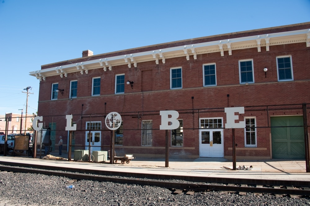
Closer to Globe, the rail yard that once hummed with activity has been partially repurposed. While many tracks have been removed, the substantial brick roundhouse where locomotives were maintained and turned remains standing, now serving as a storage facility for a local construction company. The adjacent depot, after years of abandonment, has been restored by the Gila County Historical Society and now houses a small museum dedicated to the area’s railroad and mining heritage.
The most accessible section for modern exploration follows the old grade between Miami and Globe, where Pinal Creek parallels the route. Several hiking trails incorporate segments of the former right-of-way, including the popular Stairiway Trail that utilizes a series of switchbacks originally built for a narrow-gauge spur serving the Castle Dome Mine. Interpretive signs installed by the historical society identify key features and explain their historical significance, making this section particularly rewarding for visitors interested in transportation archaeology.
The Arizona Eastern’s Globe Branch, like many specialized railroad lines, fell victim to changing economic circumstances, technological evolution, and shifting transportation patterns. Its decline unfolded gradually through several distinct phases, beginning shortly after reaching its operational peak during World War I.
The first significant challenge came with the post-war recession of 1921-22, when copper prices collapsed from their wartime highs of 26 cents per pound to less than 10 cents. Mines throughout the Globe-Miami district reduced operations or shut down entirely. The resulting decrease in ore shipments dramatically reduced railroad traffic and revenue. Southern Pacific, which had leased the Arizona Eastern since 1910 and would fully absorb it in 1924, responded by reducing service to three trains weekly rather than daily departures.
A brief revival occurred during the 1920s economic boom, but the Great Depression delivered a nearly fatal blow. By 1932, copper had fallen to just 5 cents per pound, making even the richest deposits marginally profitable at best. Several major mines suspended operations entirely, while others maintained only skeleton crews performing maintenance and development work rather than active production. Railroad traffic dwindled to occasional shipments, with many employees furloughed or reassigned to other Southern Pacific lines.
World War II temporarily reversed this decline as copper again became a strategic material vital to the war effort. The federal government guaranteed above-market prices to stimulate production, mines reopened, and railroad traffic briefly returned to near-peak levels. For a few years, it appeared the Globe Branch might have gained a new lease on life.
This revival proved short-lived. The post-war period brought two technological developments that would ultimately doom the line: the diesel truck and improved highway construction. As Arizona’s road network expanded and truck designs became more powerful and reliable, mining companies discovered they could transport ore and supplies more flexibly and often more economically by road rather than rail. The completion of improved highways between Globe and Phoenix (US 60) and Globe and Safford (US 70) provided direct connections that the circuitous rail route couldn’t match.
Southern Pacific responded by gradually reducing service and maintenance. By the late 1950s, trains operated just once weekly, primarily serving several remaining customers who still found rail transport economical for bulk shipments. Track conditions deteriorated as maintenance was deferred, leading to slower speeds and occasional derailments that further undermined customer confidence.
The final chapter began in 1983, when devastating floods along Pinal Creek washed out several miles of track in the canyon. Facing repair costs estimated at over $2 million and diminishing traffic volumes that couldn’t justify such expenditure, Southern Pacific applied to the Interstate Commerce Commission for abandonment authority. Despite opposition from some local interests and historical preservation advocates, the abandonment was approved in 1984.
The last train—a special farewell excursion organized by railroad enthusiasts—traversed the passable portions of the line on November 17, 1984. Afterwards, salvage crews removed most rails and marketable materials, leaving behind the skeletal roadbed, bridges, and structures visible today.
The abandoned Globe Branch now serves as a linear archaeological site documenting important aspects of Arizona’s industrial and transportation history. Its significance extends beyond mere nostalgic interest, offering tangible connections to economic, social, and technological developments that shaped the modern Southwest.
From an engineering perspective, the route represents a remarkable achievement in overcoming topographical challenges. The solutions employed—from the precisely calculated grades that balanced locomotive capabilities against terrain constraints to the innovative bridge designs that withstood flash floods—demonstrate the technical expertise railroad builders brought to frontier Arizona. Several features, including the Devil’s Canyon tunnel and the Hawk Hollow bridge, have been documented by the Historic American Engineering Record as significant examples of early 20th century railroad engineering.
The route’s path through the San Carlos Apache Reservation adds another dimension of historical significance, illustrating the complex relationship between transportation infrastructure, resource extraction, and indigenous communities. When originally constructed, the railroad represented an unwelcome incursion into Apache territory, granted through federal authority with minimal tribal consultation. Over time, however, it became incorporated into reservation life, providing employment opportunities and connecting tribal communities to external markets for livestock and crafts.
For modern Apache communities, the abandoned right-of-way holds mixed meanings—simultaneously representing historical oppression and economic opportunity. The San Carlos Apache Cultural Center has incorporated railroad history into its interpretive programs, acknowledging this complexity while emphasizing indigenous perspectives often absent from traditional railroad histories.
The line’s role in Arizona’s mining economy extends beyond simply transporting ore. By connecting remote districts to national markets, the railroad fundamentally altered the economics of mining, making previously marginal deposits profitable through reduced transportation costs. This transformation accelerated the shift from individual prospectors to corporate mining—a change with profound implications for labor relations, community development, and environmental impact throughout the copper districts.
Recognizing these multiple significance factors, portions of the Globe Branch have received formal historical designation. The Globe-Miami segment was listed on the National Register of Historic Places in 1997 as a historic transportation corridor, acknowledging both its engineering significance and its role in regional development. This designation has facilitated preservation efforts and qualified certain projects for historical conservation funding.
While much of the Globe Branch has been left to gradual reclamation by natural processes, several segments have benefited from conservation efforts and adaptive reuse initiatives. These projects demonstrate how abandoned transportation corridors can find new purpose while preserving their historical character.
The most successful conversion exists in the six-mile segment between Globe and Miami, now developed as the Pinal Creek Trail. This multi-use recreational pathway follows the old railroad grade, taking advantage of its gentle slope and substantial engineering to provide a stable route for hikers, cyclists, and equestrians. Interpretive signs identify remaining railroad features while explaining their historical context, creating an outdoor museum of industrial heritage.
Trailhead facilities at both the Globe and Miami ends incorporate railroad themes, with a restored caboose serving as a visitor center and information point at the Globe terminus. Local preservation groups have installed replica semaphore signals and switch stands at key points, helping visitors visualize how the line once functioned. Annual “Railroad Days” events feature historical reenactors, model railroad displays, and guided interpretive hikes that attract heritage tourists to the economically challenged communities.
Conservation efforts have focused particularly on the line’s most significant structures. The Devil’s Canyon tunnel has been stabilized by the Forest Service, with gates installed to prevent unauthorized entry while allowing important bat colonies to continue using the structure. Several of the most substantial bridges have received structural assessments and minimal interventions to prevent collapse, preserving them as landscape features visible from nearby highways.
The former Globe depot’s transformation into a museum represents perhaps the most comprehensive preservation success. After decades of neglect following Southern Pacific’s departure, the building had deteriorated significantly by the early 2000s. A community-based preservation campaign raised funds for a proper restoration, completed in 2008. The building now houses exhibits on railroad operations, mining technology, and community development, with a particular emphasis on the diverse workforce that built and operated the transportation systems.
These preservation efforts face ongoing challenges, particularly regarding funding sustainability and balancing access with resource protection. Climate change presents additional threats, as increasing frequency of extreme weather events—particularly flash floods—endangers structures that have already weathered over a century of Arizona’s harsh conditions. The linear nature of the resource, stretching across multiple jurisdictions and land ownership patterns, further complicates coordinated preservation planning.
Despite these challenges, the Globe Branch has become something of a model for railroad heritage preservation in the Southwest. Its combination of accessible segments for casual visitors and more remote sections appealing to dedicated history enthusiasts provides multiple engagement opportunities. Documentation projects, including professional archaeological surveys and citizen science initiatives, continue to record features before they disappear—creating a comprehensive inventory of this transportation landscape.
For those interested in experiencing Arizona’s ghost railways firsthand, the Globe Branch offers accessible options ranging from casual afternoon exploration to challenging backcountry adventures. Regardless of which segments you choose to visit, approaching these historical resources with appropriate knowledge and respect enhances both the visitor experience and helps preserve these fragile reminders of transportation history.
The Pinal Creek Trail between Globe and Miami provides the most developed access to the former railroad, with designated parking areas, interpretive signage, and a maintained pathway suitable for most ability levels. The Gila County Historical Society (open Tuesday through Saturday, 10 AM to 4 PM) offers guidebooks, maps, and occasional guided tours that provide historical context and identify features that might otherwise go unnoticed.
For those seeking to explore more remote segments, preparation becomes essential. Much of the right-of-way crosses public lands administered by the Forest Service or Bureau of Land Management, where access is generally permitted but facilities are non-existent. Visitors should carry adequate water, sun protection, and navigation tools. Summer exploration is discouraged due to extreme heat, with spring and fall offering more comfortable conditions.
The section through the San Carlos Apache Reservation requires special consideration. While the tribe does not categorically prohibit access to the abandoned railroad, visitors should obtain a recreation permit from the Tribal Recreation and Wildlife Department in San Carlos. This permit system allows the tribe to monitor visitation while providing revenue for conservation programs. Visitors should approach reservation lands with particular cultural sensitivity, recognizing that features Anglo visitors might see merely as “abandoned” may hold ongoing cultural significance for Apache communities.
Several ethical considerations should guide any visit to Arizona’s ghost railways. Archaeological resources along the route—from industrial artifacts to the personal items of railroad workers—are protected by various federal and state laws. Visitors should photograph rather than collect such materials, ensuring that the context and information they provide remains intact for future researchers.
The structural safety of abandoned railroad features presents another important consideration. Tunnels, bridges, and buildings along the route have deteriorated over decades of abandonment and exposure to harsh environmental conditions. Interior exploration of structures like the Devil’s Canyon tunnel or the Rice Station ruins carries significant risk and is discouraged by land management agencies. Viewing these features from a safe distance provides a similar historical connection without endangering either visitors or the structures themselves.
Wildlife has reclaimed many portions of the route, with abandoned tunnels serving as bat hibernation sites and remote sections providing habitat for sensitive species including desert bighorn sheep. Visitors should minimize disturbance to these animals, particularly during breeding seasons or extreme weather conditions when additional stress could prove harmful.
Photography of the route and its features is generally permitted and encouraged for personal documentary purposes, though commercial photography may require permits depending on jurisdiction. Many railroad enthusiasts and historians contribute their photographs to archives and documentation projects, creating a valuable visual record of features that continue to deteriorate or disappear with each passing year.
As shadows lengthen across the rusted bridges and crumbling grades of the Arizona Eastern’s Globe Branch, these industrial artifacts stand as eloquent witnesses to the transitory nature of even our most substantial infrastructure. What once represented cutting-edge technology and economic lifeblood has, in less than a century, become archaeological—a physical reminder that today’s essential systems may likewise fade into obsolescence as technologies and economies evolve.
The story of this ghost railway reflects larger patterns in Western American development, where transportation corridors not only connected communities but often determined their very viability. The same rails that brought prosperity to Globe and Miami stitched these remote mountain towns into national economic networks while simultaneously making them vulnerable to distant market forces and corporate decisions. When copper prices plummeted or Southern Pacific executives calculated that maintenance costs exceeded potential revenue, communities built around railroad accessibility found themselves suddenly marginalized—their economic foundation eroded by the same forces that had once created it.
Yet even in abandonment, these pioneer pathways maintain a ghostly influence on the landscape they traverse. The engineered grades still channel seasonal floodwaters, the cuts and tunnels continue to provide wildlife corridors, and the visible right-of-way shapes how modern residents and visitors understand the region’s geography and history. Though trains no longer rumble along these routes, their absence speaks as eloquently as their presence once did about the economic forces, technological changes, and human aspirations that continue to reshape the Arizona landscape.
For contemporary visitors tracing these fading imprints on the desert floor, the experience offers something increasingly rare in our digital age—tangible, physical connection to the technologies and transportation systems that built modern Arizona. Walking along the stabilized roadbed between Globe and Miami, where generations of railroaders once maintained the steel pathway, creates a direct link to the industrial past that screens and virtual experiences cannot replicate.
The preservation of these transportation ghosts—whether through formal adaptive reuse projects like the Pinal Creek Trail or simply through documentation before they vanish entirely—serves not merely nostalgic purposes but educational ones as well. In understanding how earlier generations built, operated, and ultimately abandoned complex infrastructure systems, we gain perspective on our own transportation networks and the inevitable transitions they too will undergo as technologies and needs evolve.
As sunset gilds the scattered remnants of what was once a vital artery of commerce and communication, these silent witnesses remind us that all infrastructure—even the most essential—exists within historical currents that eventually render it obsolete. The ghost railways of Arizona, like the communities they once served, stand as monuments to both human ingenuity and the impermanence of our most ambitious constructions.
We use cookies to improve your experience on our site. By using our site, you consent to cookies.
Manage your cookie preferences below:
Essential cookies enable basic functions and are necessary for the proper function of the website.