Nestled in the high desert landscape of northern Arizona, Sunset Crater Volcano National Monument stands as a dramatic testament to the raw geological forces that have shaped the American Southwest. This 3,040-acre protected area preserves the remarkable cinder cone of Sunset Crater, the youngest volcano in the state, which last erupted less than 1,000 years ago. The monument’s striking black lava flows, red-tinged volcanic cinder fields, and resilient pockets of vegetation offer visitors a rare glimpse into the aftermath of volcanic activity and the slow process of ecological recovery.
Established as a national monument in 1930, Sunset Crater’s protection came after a Hollywood film company proposed to use explosives on the cinder cone for a movie scene—a plan that sparked public outcry and led to the area’s conservation. Today, the monument serves as both an outdoor laboratory for scientists studying volcanic geology and ecological succession, and a fascinating recreational destination for visitors seeking to explore Arizona’s diverse natural heritage.
Situated just 15 miles northeast of Flagstaff, Sunset Crater Volcano National Monument is part of a larger volcanic field that includes over 600 volcanoes scattered across the Colorado Plateau. Its accessibility, scientific significance, and striking visual landscape make it an essential destination for anyone interested in the geological wonders of the American Southwest.
Start your visit at the Sunset Crater Visitor Center, where you can learn about the history of the eruption and its impact on the environment. The center features informative exhibits, a short film, and displays about the geology, ecology, and cultural importance of the area. It’s a great place to get an overview before heading out to explore the monument.
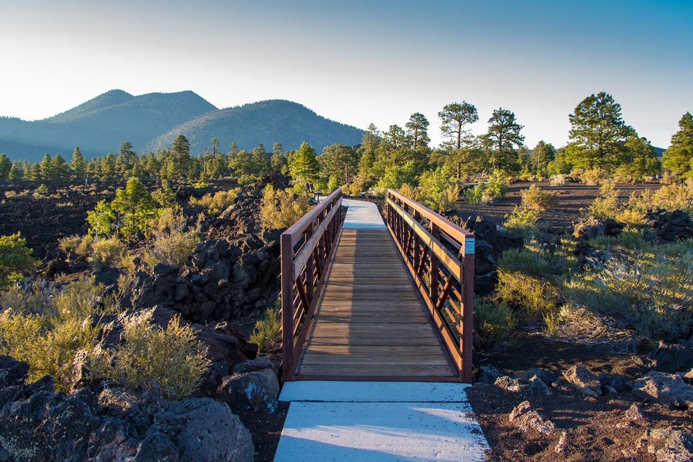
The Lava Flow Trail is the most popular trail in the monument, offering an up-close look at the lava fields and volcanic terrain. This easy, 1-mile loop provides stunning views of the cinder cone and unique geological formations, such as jagged lava rocks and spatter cones. Interpretive signs along the trail explain the volcanic processes that shaped the landscape.
For those seeking a more challenging hike, the Lenox Crater Trail is a 1.6-mile round-trip hike that leads to the top of an ancient cinder cone. The trail offers sweeping views of the surrounding volcanic field and the San Francisco Peaks. It’s a steep but rewarding hike for those looking to immerse themselves in the volcanic landscape.

The volcanic eruption at Sunset Crater played a significant role in the lives of the Native American communities in the region. Interpretive displays and ranger programs highlight how the eruption impacted agriculture, settlement patterns, and cultural practices. You can see ancient ruins at nearby Wupatki National Monument, where many people relocated after the eruption.

While there are no accessible lava tubes to explore within the monument, the Lava Flow Trail allows visitors to see the remnants of ancient lava channels and collapsed tubes. Nearby attractions, such as the Lava River Cave in Coconino National Forest, offer opportunities for exploring underground lava formations (just outside the monument).

Rangers at the monument host educational programs, including guided hikes and talks. These programs provide deeper insights into the volcanic processes, plant and animal adaptations, and the cultural history of the region. Check with the Visitor Center for the latest schedule.

Enjoy a picnic at one of the designated areas within the monument. These spots offer peaceful settings to relax and take in the stunning volcanic landscape. Be sure to pack out all trash to help preserve the natural environment.
Sunset Crater Volcano National Monument is part of the Flagstaff area, which is known as the world’s first International Dark Sky City. On clear nights, the monument offers exceptional stargazing opportunities. Bring a telescope or simply lay back and enjoy the brilliant display of stars and planets.

The 35-mile Scenic Loop Road connects Sunset Crater Volcano National Monument with nearby Wupatki National Monument. Along the way, you’ll enjoy breathtaking views of lava fields, cinder cones, and desert landscapes. This drive offers excellent opportunities for photography and exploring both monuments in one trip.

| Category | Details |
|---|---|
| Location | Northern Arizona, near Flagstaff, USA |
| Established | May 26, 1930 |
| Managed By | National Park Service |
| Size | Approximately 3,040 acres (1,230 hectares) |
| Main Attractions | Sunset Crater Volcano, Lava Flow Trail, Bonito Lava Flow |
| Geological Significance | Preserves the cinder cone and lava fields from an eruption that occurred around 1085 CE |
| Cultural Significance | The eruption impacted nearby Indigenous communities and influenced migration patterns. |
| Time Period | The volcano erupted approximately 1,000 years ago |
| Ecosystem | High desert with volcanic soils supporting unique plants and animals |
| Nearby Landmarks | Wupatki National Monument, San Francisco Peaks |
| Visitor Activities | Hiking, photography, ranger-led programs, and volcano education |
| Climate | Cool winters, warm summers; higher elevation results in mild conditions |
| Entrance Fee | $25 per vehicle (valid for 7 days, includes access to Wupatki National Monument; fees subject to change) |
| Accessibility | Visitor center and Lava Flow Trail are wheelchair accessible in parts |
| Fun Fact | The eruption of Sunset Crater Volcano was so impactful that it created new farming opportunities for the local Sinagua people due to enriched volcanic soil. |
Sunset Crater represents the youngest volcano in a vast field of volcanic features in northern Arizona. Its relatively recent formation—erupting between 1040 and 1100 CE—provides scientists and visitors with an exceptional opportunity to observe the early stages of ecological recovery following volcanic activity.
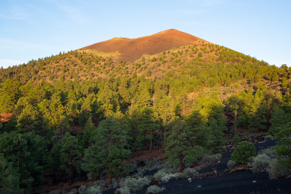
The namesake cinder cone rises about 1,000 feet above the surrounding landscape, crowned with a rim stained with oxidized iron and sulfur deposits that give the crater its distinctive “sunset” hues of red, orange, and yellow. This coloration, especially dramatic during the golden hours of sunrise and sunset, inspired its name and continues to captivate visitors today.
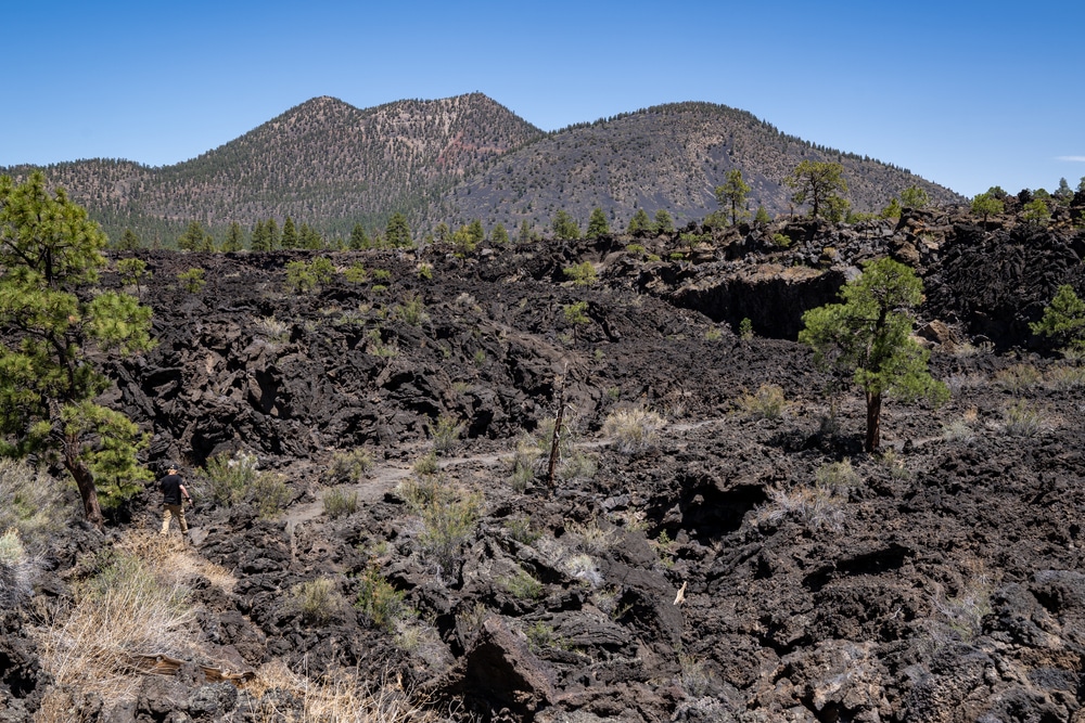
The monument also preserves extensive lava flows, including the Bonito Flow, which covers approximately 1.8 square miles with jagged black basaltic rock. These formations include fascinating features such as:
The Kana-a Flow extends from the base of the crater to the northeast, characterized by its more broken, blocky appearance.
The volcanic eruption that created Sunset Crater dramatically altered the surrounding landscape and affected the indigenous populations who had been farming the area. Ash fall from the eruption covered an area of more than 800 square miles, creating a natural mulch that actually improved agricultural conditions in some areas where a thin layer was deposited.
The monument offers several hiking trails that allow visitors to explore its volcanic features:
This accessible, partially paved trail winds through the Bonito Lava Flow, offering close-up views of fascinating volcanic features like squeeze-ups, collapse pits, and various lava formations. Interpretive signs along the path explain the geological processes and features visible along the route.
A more challenging hike that climbs the side of Lenox Crater, a cinder cone that predates Sunset Crater. The trail rewards hikers with panoramic views of the San Francisco Peaks, the Painted Desert, and Sunset Crater itself.
A section of the Arizona Trail passes near the monument, offering opportunities for longer hikes through the surrounding Coconino National Forest.
Important Note: For preservation reasons, hiking to the summit of Sunset Crater itself is prohibited. The fragile nature of the cinder cone, which is susceptible to erosion, necessitates this restriction to protect the geological feature for future generations.
The 34-mile Loop Road (combining Sunset Crater Volcano and Wupatki National Monuments) offers a spectacular driving tour through the volcanic landscape and into the red rock country of Wupatki, where ancient pueblos stand as testament to the indigenous cultures that flourished in this challenging environment. This drive provides numerous pullouts with interpretive displays and viewpoints.
With its high elevation (approximately 7,000 feet) and distance from major urban light sources, Sunset Crater offers excellent opportunities for stargazing. The monument occasionally hosts night sky programs during summer months, when rangers and local astronomy clubs provide telescopes and guidance for viewing celestial objects.
The stark contrast between black lava flows, red cinder fields, and the surrounding ponderosa pine forest creates countless opportunities for compelling photography. Dawn and dusk are particularly magical times, when the changing light enhances the colorful minerals in the cinder cone that give Sunset Crater its name.
The eruption of Sunset Crater around 1085 CE had profound effects on the indigenous peoples living in the region. Archaeological evidence suggests that farming communities of ancestral Puebloan people inhabited the area before the eruption. The volcanic event forced immediate evacuation of the area closest to the vent but created new agricultural opportunities in areas that received a thin covering of ash.
Following the eruption, a significant cultural florescence occurred in the surrounding region, particularly at Wupatki, where complex pueblos were constructed. The relationship between the volcanic event and cultural changes in the region continues to be a subject of archaeological research.
For the modern Hopi, Zuni, and other Puebloan peoples, Sunset Crater holds cultural significance as part of their ancestral landscape. These communities maintain cultural connections to the monument and the surrounding region through oral traditions and continuing cultural practices.
Sunset Crater provides a fascinating glimpse into primary ecological succession—the process by which life gradually reclaims a landscape after a major disturbance. Even after nearly a millennium, large areas of the lava flows remain largely barren, demonstrating the extremely slow pace of succession in this harsh environment.
The monument encompasses several distinct ecological zones:
These areas of loose volcanic cinders support sparse, specialized vegetation including Apache plume, rabbit brush, and various grasses that have adapted to the challenging substrate.
The solid lava presents an even more challenging environment for plants. Pockets of windblown soil allow pioneer species like Apache plume, rockspirea, and eventually ponderosa pine to gain footholds in cracks and depressions.
Around the edges of the volcanic features, ponderosa pine forest gradually reclaims the landscape, creating an interesting ecological boundary that demonstrates the slow process of forest regeneration.
Wildlife in the monument includes mule deer, pronghorn antelope, various rodents, and numerous bird species adapted to both forest and open habitats. Reptiles such as the plateau lizard and short-horned lizard can be spotted during warmer months.
Sunset Crater Volcano National Monument is located approximately 15 miles northeast of Flagstaff, Arizona via US Highway 89 and Sunset Crater Road (Forest Road 545). The monument is open year-round, though winter weather can occasionally affect access.
The monument’s visitor center offers exhibits on the geology, ecology, and cultural history of the area. Rangers provide information about current conditions and can help visitors plan their exploration of the monument. Educational displays include interactive exhibits explaining volcanic processes and the natural and cultural history of the region.
Spring (April-June) and fall (September-October) offer the most comfortable temperatures for exploring the monument. Summer months can be quite warm, especially on the exposed cinder fields and lava flows where heat radiating from the dark volcanic rock can significantly raise the ambient temperature. Winter brings snow to this high-elevation site, creating a striking visual contrast but sometimes limiting access to certain areas.
An entrance fee is charged for visitors to Sunset Crater Volcano National Monument. The fee also covers admission to neighboring Wupatki National Monument within a seven-day period. Annual passes, including the America the Beautiful National Parks and Federal Recreational Lands Pass, are also accepted.
Special use permits may be required for commercial activities, group events, or scientific research within the monument boundaries.
The monument provides:
Sunset Crater Volcano National Monument is part of a rich network of public lands in northern Arizona, offering opportunities to explore diverse landscapes and cultural sites:
Connected to Sunset Crater by the Loop Road, Wupatki preserves ancient pueblos built by indigenous peoples following the eruption of Sunset Crater. The contrast between the volcanic landscape and red rock desert with archaeological treasures makes this a compelling combined visit.
Surrounding the monument, this vast national forest provides additional recreational opportunities including hiking, mountain biking, camping, and winter sports.
Located east of Flagstaff, this monument preserves cliff dwellings built into the walls of a scenic canyon—another aspect of ancestral Puebloan culture in the region.
Just over an hour’s drive to the north, the Grand Canyon offers a different but equally impressive geological spectacle.
Visible from many points within Sunset Crater, these mountains within Coconino National Forest include Arizona’s highest peak and offer hiking, skiing, and botanical diversity.
As with many public lands, Sunset Crater Volcano National Monument faces several conservation challenges:
The fragile cinder cone and lava features can be easily damaged by foot traffic, which led to the closure of the summit trail in 1973 to prevent further erosion.
Non-native plants such as cheatgrass threaten to alter the natural succession processes occurring on the volcanic landscapes.
Increasing temperatures and changing precipitation patterns may affect the already harsh conditions for plant establishment and survival on the volcanic features.
The National Park Service implements various management strategies to address these challenges, including:
Regular assessment of geological features, vegetation recovery, and wildlife populations helps managers track changes over time.
Efforts to remove invasive species and promote native plant communities help maintain the natural ecological succession processes.
Interpretive programs and materials help visitors understand the monument’s significance and encourage responsible visitation practices.
At 7,000 feet elevation, weather can change rapidly. Visitors should be prepared for strong sun, sudden thunderstorms in summer, and snow in winter.
The volcanic terrain is rough and uneven. Sturdy hiking shoes with good ankle support are recommended for walking the trails.
The high elevation and exposed landscape intensify sun exposure. Sunscreen, hats, and sunglasses are essential, especially during summer months.
The dry climate and heat radiating from dark volcanic rocks necessitate carrying and drinking plenty of water, even on short hikes.
Visitors should maintain a respectful distance from all wildlife and be aware of potential encounters with venomous snakes during warmer months.
The visitor center and portions of the Lava Flow Trail are wheelchair accessible. The visitor center provides accessible restrooms and exhibits designed to accommodate visitors with various needs.
Visitors are encouraged to:
Sunset Crater Volcano National Monument offers a rare opportunity to witness the dramatic aftermath of volcanic activity and the remarkable resilience of nature in reclaiming a devastated landscape. As one of Arizona’s lesser-known national monuments, it provides a more intimate experience with the state’s geological wonders than some of its more famous counterparts.
The monument’s proximity to Flagstaff and its connection to other significant public lands make it an ideal component of a broader exploration of northern Arizona’s natural and cultural heritage. Whether visited as a quick educational stop along the scenic Loop Road or explored in depth through its trail system, Sunset Crater rewards visitors with insights into the powerful forces that have shaped our planet and the persistent capacity of life to return even after catastrophic events.
As climate change and increasing visitation present ongoing challenges to public lands throughout the Southwest, Sunset Crater’s conservation becomes increasingly important—not only for its scientific value and recreational opportunities but also for its ability to connect visitors with the dynamic geological processes that continue to shape our world. Through responsible visitation and support for conservation efforts, we can help ensure that this volcanic wonder remains preserved for future generations to study and enjoy.
We use cookies to improve your experience on our site. By using our site, you consent to cookies.
Manage your cookie preferences below:
Essential cookies enable basic functions and are necessary for the proper function of the website.
Statistics cookies collect information anonymously. This information helps us understand how visitors use our website.
Marketing cookies are used to follow visitors to websites. The intention is to show ads that are relevant and engaging to the individual user.