The wind carries secrets across the high desert plateaus of southeastern Arizona, whispering through mesquite and creosote bush, over weathered stone ruins and lonely graves. Here, among the scattered remnants of stage stations and watering holes, lies a story largely forgotten by modern travelers rushing along Interstate 10. This is the legacy of the Butterfield Overland Mail Route—America’s first regular transcontinental mail and passenger service—which briefly but significantly connected Arizona Territory to the wider nation at a pivotal moment in both regional and national history.
The human stories associated with the Butterfield route provide perhaps the most compelling connection to this historical transportation network. The four graves at Dragoon Springs belong to real individuals who died far from home while participating in this ambitious communication effort.
Station keeper Isaac Skillman embodied the bold, restless spirit that characterized many frontier entrepreneurs. Before taking the position at Dragoon Spring, he had served as an express rider and guide in Texas, gaining fame for his knowledge of desert trails and ability to navigate hostile territory. His decision to accept the dangerous assignment at Dragoon Spring—in territory known to be contested by Apache bands—reflected both the economic opportunities and substantial risks of frontier enterprise.
The unnamed Mexican laborers buried alongside Skillman represent the often-overlooked multicultural nature of Arizona’s pioneer period. Mexican workers provided much of the labor that built and maintained the infrastructure of early territorial Arizona, from stage roads to mining operations. That their names went unrecorded in company documents while Skillman’s was preserved illustrates the differential value placed on lives in this stratified frontier society.
The attack that claimed these four lives appears in several firsthand accounts, including a report by John Butterfield Jr. who visited the site shortly after the incident. According to these accounts, the station was approached by a group of Apache warriors initially appearing peaceful. When the occupants let down their guard, the attack commenced, with Skillman and three workers killed while two others escaped to bring news to the next station.
Beyond these dramatic incidents, daily life at Butterfield stations involved considerable hardship. Station keepers and stock tenders lived in isolated conditions, responsible for maintaining fresh horses, providing basic meals for passengers, and defending remote outposts with limited support. Many stations had only two or three permanent staff, though this number could temporarily increase during infrastructure construction or repair projects.
Passengers experienced the journey differently, though few found it comfortable. Journalist Waterman L. Ormsby, who traveled the entire route shortly after its establishment and wrote about it for the New York Herald, described the experience as “the hardest trip I ever made in my life.” Coaches traveled day and night, stopping only briefly to change teams or allow passengers quick meals at stations. With nine passengers often crowded into a space designed for that maximum number, travelers endured dust, heat, cold, and inevitable disagreements over limited space throughout the journey.
| Aspect | Details |
|---|---|
| Name | Butterfield Overland Mail Route |
| Established | 1857 |
| Founder | John Butterfield, a businessman and transportation entrepreneur |
| Purpose | To deliver U.S. mail and passengers between St. Louis, Missouri, and San Francisco, California, across the southern United States. |
| Route | – Spanned approximately 2,800 miles. |
| – Followed a southern path through Missouri, Arkansas, Texas, New Mexico, Arizona, California, and other territories. | |
| – Avoided the Rocky Mountains and northern snow-covered routes. | |
| Key Stops | – St. Louis, Missouri (Eastern Terminus) |
| – Fort Smith, Arkansas | |
| – El Paso, Texas | |
| – Tucson, Arizona | |
| – Los Angeles, California | |
| – San Francisco, California (Western Terminus) | |
| Travel Time | – Approximately 22 days to deliver mail and passengers from St. Louis to San Francisco. |
| – Operated 24/7, with stagecoaches running day and night. | |
| Significance | – Connected the eastern U.S. with the rapidly growing west during a time of expansion. |
| – Played a critical role in communication and commerce. | |
| – Provided a reliable mail service before the advent of the Pony Express and the transcontinental railroad. | |
| Challenges | – Harsh terrain, including deserts, mountains, and rivers. |
| – Hostile encounters with Native American tribes resisting westward expansion. | |
| – Extreme weather conditions, such as heat in deserts and snow in higher elevations. | |
| Decline | – Service ended in 1861 due to the outbreak of the Civil War. |
| – The Pacific Railroad Act (1862) eventually led to the transcontinental railroad, which replaced stagecoach routes for mail and passenger service. | |
| Legacy | – The route is recognized as a significant part of U.S. history and westward expansion. |
| – Designated a National Historic Trail by Congress in 2009. | |
| Modern Remnants | – Portions of the route are preserved as historical landmarks, trails, and museums. |
| – Sites such as the Butterfield Stage Station Ruins in Arizona and Fort Bowie commemorate its history. |
In 1857, with the United States rapidly expanding westward and tensions between North and South intensifying, communication across the vast continent became increasingly vital. The federal government awarded a contract to John Butterfield’s overland mail company to establish regular twice-weekly mail and passenger service between St. Louis, Missouri and San Francisco, California. The ambitious 2,800-mile route would cut through the southern portion of the continent, traversing Texas, the newly acquired Gadsden Purchase lands of southern Arizona, and California.
Before this connection, mail to California took months by ship around South America or via unreliable and intermittent overland couriers. The Butterfield route promised delivery in 25 days or less—a revolutionary improvement that would strengthen America’s tenuous hold on its western territories just a decade after the Mexican-American War had transferred the region to U.S. control.
The significance of this development cannot be overstated. As historian Gerald T. Ahnert writes, the Butterfield Overland Mail represented “America’s first serious attempt to connect its eastern and western territories through regular, scheduled transportation service—a precursor to the transcontinental railroad and later highway systems.”
Within Arizona Territory specifically, the route ran from the Stein’s Peak station near the present New Mexico border through Apache Pass, Dragoon Springs, Tucson, and on toward California via Yuma. Each stop along this corridor became a tenuous outpost of American presence in a landscape still largely controlled by indigenous peoples, particularly the Chiricahua Apache under leaders like Cochise.
What remains of the Butterfield Route today exists primarily as scattered ruins, faint trail remnants, and isolated grave markers. Unlike ghost towns with their photogenic false-fronted buildings, Butterfield stations were utilitarian structures built for function rather than permanence—often simple stone buildings positioned near reliable water sources.
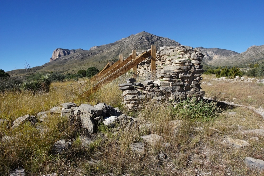
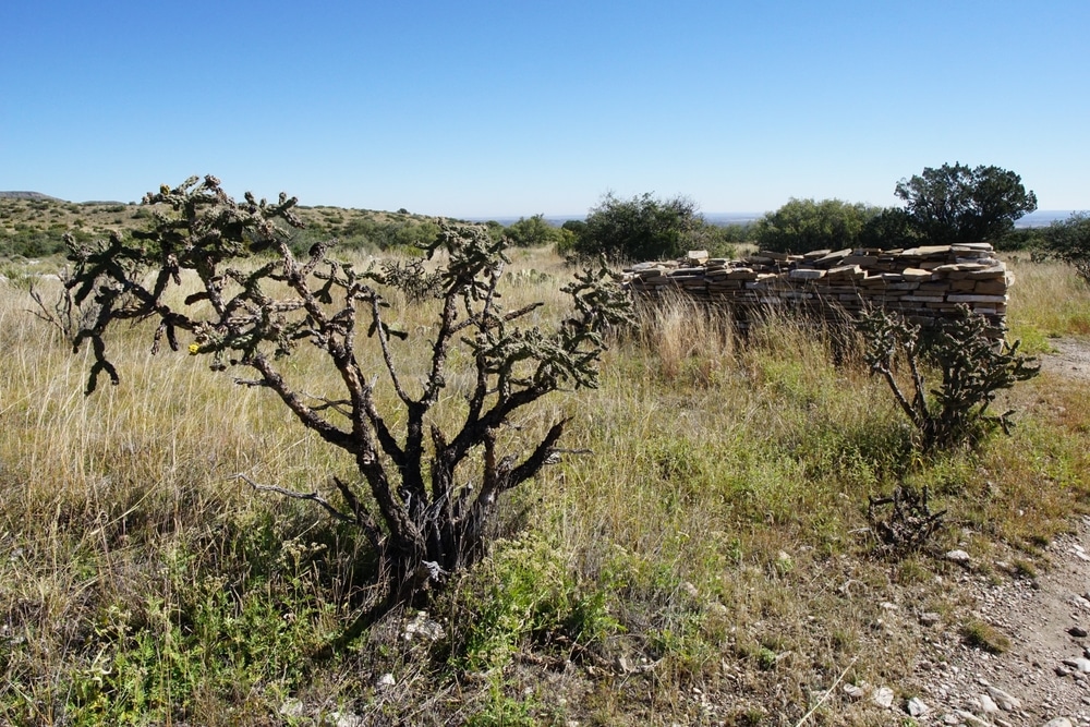
Dragoon Springs Station offers perhaps the most evocative connection to this vanished transportation network. Located approximately 20 miles east of Tombstone in Cochise County, the site features waist-high stone walls arranged in a roughly rectangular pattern measuring approximately 40 by 20 feet. These walls were constructed using “dry stacking” techniques—stones fitted together without mortar—by workers who had to make do with local materials in this remote location.
The station was strategically positioned to take advantage of both the natural spring and the defensive properties of the landscape. Built against a rocky hillside, it provided occupants with some protection from potential attacks while maintaining clear sight lines across the surrounding terrain. The spring itself emerges from the base of a rocky outcropping approximately fifty yards from the station ruins, still trickling water as it has for centuries.
Nearby, a small cemetery contains four stone cairns marking the graves of station keeper Isaac Skillman and three Mexican employees killed during an Apache attack in 1858, just months after the Butterfield route began operation. These simple burial markers—piles of stones gathered from the surrounding landscape—represent some of the human cost of establishing this transportation corridor through contested territory.
Other stations along Arizona’s portion of the route have fared differently. At Stein’s Peak, little remains beyond foundation stones, while the Tucson station site has been lost beneath urban development. San Simon station survives primarily through archaeological evidence, with limited above-ground features visible to casual observers.
The Butterfield Overland Mail operation in Arizona proved both groundbreaking and brief. The first stages began their bi-weekly runs in 1858, with coaches leaving simultaneously from St. Louis and San Francisco and passing each other somewhere along the route. The journey took approximately 25 days, with passengers enduring a grueling schedule that involved traveling day and night with only brief stops for meals and team changes.
John Butterfield Jr., son of the company’s founder who visited Dragoon Springs shortly after the 1858 attack, described the coaches used: “Specially built for the route, the Concord coaches could carry nine passengers inside on three seats, with additional travelers sometimes perched on the roof alongside mail pouches and luggage.” These coaches, manufactured by Abbot, Downing & Company of Concord, New Hampshire, became iconic symbols of westward expansion, though few realized how short-lived their service along this particular route would be.
The Butterfield service operated for just three years before the outbreak of the Civil War in 1861 forced a significant change. Concerned about Confederate sympathizers potentially disrupting mail service along the southern route, the federal government shifted operations northward to a central route through Utah and Nevada. This left the Arizona stations without their primary purpose, though some continued to serve military units moving through the territory during the Civil War years.
Despite its brief duration, the Butterfield route had significant impacts on Arizona’s development. It established transportation corridors that would influence later road and railroad alignments, created the first regular communication channels between the territory and the eastern states, and demonstrated the strategic importance of controlling key water sources throughout the arid region.
The Butterfield route existed in contested space. The surrounding mountains and valleys were the homeland of the Chiricahua Apache, led by renowned leaders including Cochise. The establishment of stage stations represented incursions into their territory, leading to tensions that would ultimately erupt into violence and directly impact the route’s history.
The most well-documented incident occurred at Dragoon Springs in 1858, just months after the Butterfield route began operation. According to historical records, a party of Mexican laborers who had been hired to improve the road approaching the station were attacked by a group of Apache warriors. The station keeper Isaac Skillman and three employees were killed in the violence, becoming the first casualties associated with the Butterfield route in Arizona Territory.
This incident became part of the larger narrative of Apache resistance to American encroachment in the region. Cochise, the prominent Chiricahua Apache leader, was initially blamed for the attack, though later historical research suggests it may have been carried out by a different band. Regardless, the violence at Dragoon Spring contributed to escalating tensions that would ultimately lead to the Apache Wars that dominated southeastern Arizona’s history for the next three decades.
Other stations along the route experienced similar incidents. The Apache Pass station, positioned at a strategic mountain pass, became a frequent target for raids. These conflicts ultimately led to the establishment of Fort Bowie near the station site in 1862, after the Butterfield service had already been relocated to the northern route.
These confrontations represented a fundamental collision of worldviews and interests. For the Apache, the stage stations and increased traffic along the route threatened control of traditional territories and critical water sources. For Butterfield employees and passengers, the stations represented tenuous outposts of American presence in what was perceived as dangerous and hostile territory. This tension would continue long after the mail route itself had been abandoned.
The abandonment of the southern Butterfield route in 1861 represented just one transition in the evolving transportation landscape of Arizona Territory. Over subsequent decades, the corridors established by the stage line would influence the development of railroads, highways, and eventually the interstate system that carries travelers through the region today.
After the Civil War, portions of the route continued to serve military and civilian traffic, though never again with the regular scheduled service of the Butterfield era. Some former stations found new purposes serving ranchers, miners, or military units operating in the region. The Apache Pass station site, for instance, became incorporated into Fort Bowie, which operated from 1862 to 1894 as a key military post during the Apache Wars.
The most significant transportation shift came with the arrival of the Southern Pacific Railroad across southern Arizona in 1880. This new transportation artery paralleled much of the old Butterfield route but bypassed many of its stations. As rail service provided faster, more comfortable, and safer transit across Arizona Territory, the old stage stations lost their purpose and were largely abandoned.
The railroad was eventually followed by automobile routes, with the establishment of the first state highways in the early 1900s and eventually the designation of U.S. Highway 80 along portions of the corridor. The final transformation came with the construction of Interstate 10, which follows a similar east-west course through southern Arizona but prioritizes engineering efficiency over the water-focused route selection that had determined the Butterfield alignment.
Today, thousands of travelers speed along I-10 each day, few realizing they are following a transportation corridor established more than 160 years ago by stagecoaches carrying mail and passengers at a pace that would seem glacial by modern standards. The ruins of Butterfield stations lie just a short distance from the interstate in many cases, nearly invisible to those moving at 75 miles per hour yet containing powerful stories of an earlier era of American connectivity.
Unlike ghost towns with their visible structures and commercial appeal, Butterfield Overland Mail sites have received relatively limited preservation attention. Their often remote locations, minimal remaining structures, and linear nature (spread across hundreds of miles rather than concentrated in a single location) create significant challenges for both physical preservation and public interpretation.
The most substantial preservation effort came in 1961 when the Butterfield Overland Mail route was designated a National Historic Trail, though this designation provided limited practical protection for individual sites. More recently, the route was included in the Arizona State Parks’ Heritage Trail system, with interpretive markers installed at accessible points along the corridor.
The Dragoon Springs station site has been listed on the National Register of Historic Places since 1978, acknowledging both its role in transportation history and its association with Apache-American conflicts during the territorial period. This designation provides some protection through recognition of historical significance, though limited resources for active preservation.
Local historical organizations like the Cochise County Historical Society and the Arizona Historical Society have conducted documentation projects at various station sites, creating photographic records and maps that preserve information about these places even as their physical remains continue to deteriorate. These efforts represent a race against time as natural erosion and occasional vandalism gradually diminish the visible evidence of this pioneering transportation route.
Contemporary memory of the Butterfield route is maintained primarily through specialist historical publications, interpretive signs at accessible sites, and the efforts of enthusiasts who trace the route using historic maps and GPS coordinates. The route’s history is featured in museums throughout southern Arizona, particularly at the Arizona Historical Society in Tucson and the Sharlot Hall Museum in Prescott, where artifacts and documents help visitors understand this significant chapter in territorial development.
Perhaps the most powerful form of preservation is simply visiting these sites with informed respect. Standing at Dragoon Springs beside the stone ruins and grave cairns, modern visitors can briefly connect with the experiences of those who established this tenuous transportation link across the continent, imagining the sounds of approaching stagecoaches, the relief of passengers reaching a water stop after hours crossing arid terrain, and the complex interactions between different cultures along this contested corridor.
For those interested in experiencing the Butterfield route firsthand, several sites offer accessible connections to this historical transportation corridor. While much has disappeared beneath later development or succumbed to natural deterioration, informed visitors can still trace portions of the route and visit key locations that shaped its history.
Dragoon Springs represents one of the most accessible and evocative sites, though reaching it requires some effort. Located approximately 20 miles east of Tombstone, the site is accessed via Dragoon Road off Highway 80, with the final approach requiring high-clearance vehicles and a short hike. The stone ruins and grave cairns provide tangible connections to the route’s history, particularly the 1858 attack that claimed four lives. No facilities exist at the site, and visitors should come prepared with water and supplies for desert conditions.
The Apache Pass segment of the route now lies within the Fort Bowie National Historic Site, operated by the National Park Service. A 1.5-mile interpretive trail leads visitors to the fort ruins and passes the site of the former Butterfield station, though little remains visible of the station itself. The visitor center provides excellent contextual information about transportation history and conflicts with the Apache during this period.
In Tucson, the approximate location of the Butterfield station is marked by a historical plaque, though urban development has erased all physical evidence of the original structure. The nearby Arizona Historical Society museum offers exhibits that include artifacts and documents related to the mail route’s operation through the territory.
Visitors seeking to trace larger portions of the route should consult Gerald T. Ahnert’s “The Butterfield Trail and Overland Mail Company in Arizona Territory,” which provides detailed maps and GPS coordinates for station locations. Many segments of the trail itself remain visible as subtle depressions or cleared pathways across the desert landscape, particularly in less-developed areas between major highways.
When visiting these sites, ethical considerations should guide behavior. Archaeological resources are protected by federal and state laws, and artifacts should never be removed, even seemingly insignificant items like metal fragments or broken glass. The grave sites at locations like Dragoon Springs deserve particular respect as the final resting places of individuals who died establishing this transportation corridor.
The best seasons for exploring the Butterfield route are spring and fall, when desert temperatures are moderate. Summer visits require careful planning due to extreme heat, while winter can bring surprisingly cold conditions at the higher elevation sites. In all seasons, visitors should carry adequate water, sun protection, and navigation tools when venturing to the more remote locations along the route.
The Butterfield Overland Mail route exists today primarily as a historical memory, its physical traces gradually disappearing into the landscape that once both facilitated and challenged its operation. Yet its significance extends far beyond the brief period of its actual service, representing a crucial chapter in how Arizona Territory—and indeed the entire American West—became integrated into the expanding nation.
For just three years, stagecoaches rolled across the territory’s dusty trails, connecting isolated outposts to distant cities and carrying both people and information across previously formidable distances. The route’s establishment required remarkable determination and engineering ingenuity, while its operation demanded courage from those who maintained stations in contested territory. That it lasted only briefly before being rendered obsolete by war and later transportation developments makes it no less significant in understanding how connecting corridors shaped settlement patterns and cultural encounters throughout the Southwest.
Today, as travelers rush along Interstate 10 with immediate digital connections to the world in their pockets, the arduousness of Butterfield’s 25-day transcontinental journey seems almost unimaginable. Yet standing beside the weathered stone walls at Dragoon Springs, where station keeper Isaac Skillman and three unnamed Mexican workers rest beneath simple cairns, the human dimension of this historical transportation network becomes palpable.
The Butterfield Overland Mail Company’s brief but consequential tenure in Arizona Territory reminds us how quickly transportation technologies evolve, how dramatically they can reshape human movement and settlement, and how their abandoned corridors continue to influence the landscapes we inhabit today. In the scattered ruins and lonely graves along this pioneer pathway, we find not just the remnants of a mail route, but the foundations of how Arizona Territory became connected to the nation it would eventually join as the 48th state.
Other station sites accessible with varying degrees of difficulty; consult Gerald T. Ahnert’s guidebook for detailed directions and access information.
All photographs used by permission of the Arizona Historical Society and Cochise County Historical Society
We use cookies to improve your experience on our site. By using our site, you consent to cookies.
Manage your cookie preferences below:
Essential cookies enable basic functions and are necessary for the proper function of the website.
Statistics cookies collect information anonymously. This information helps us understand how visitors use our website.
Monetize your website by displaying targeted ads and earning revenue from clicks and impressions.
Google Analytics is a powerful tool that tracks and analyzes website traffic for informed marketing decisions.
Service URL: policies.google.com (opens in a new window)
You can find more information about our Cookie Policy and Privacy Policy.