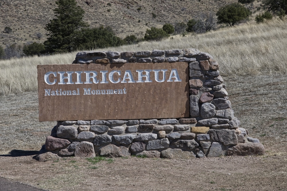
Hidden in the southeastern corner of Arizona lies one of the state’s most spectacular yet often overlooked gems—Chiricahua National Monument. Known affectionately as the “Wonderland of Rocks,” this 11,985-acre preserve showcases some of the most dramatic and bizarre rock formations in North America. Rising unexpectedly from the surrounding grasslands and desert, the Chiricahua Mountains harbor a remarkable landscape of balanced rocks, spires, columns, and hoodoos that seem to defy gravity and imagination.
Established as a national monument in 1924, Chiricahua represents the extraordinary aftermath of a massive volcanic eruption that occurred approximately 27 million years ago. The subsequent forces of erosion have shaped the resulting rhyolite tuff into a surreal stone sanctuary that has fascinated visitors for generations. Beyond its geological wonders, the monument serves as an ecological crossroads where four distinct biomes converge: the Sonoran and Chihuahuan deserts, the Rocky Mountains, and the Sierra Madre range of Mexico.

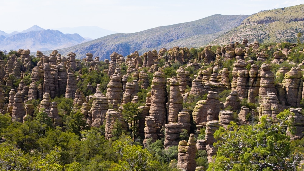
The landscape of Chiricahua National Monument was shaped by a massive volcanic eruption 27 million years ago. The eruption from the Turkey Creek Caldera spewed ash and debris that solidified into a rock called rhyolite tuff. Over time, weathering and erosion sculpted this volcanic rock into the towering spires, balanced rocks, and narrow canyons you see today.
The formations are often described as “sky islands,” as they create a unique ecosystem where desert plants coexist with mountain species. This phenomenon adds to the monument’s ecological and geological significance.

Chiricahua National Monument offers 17 miles of well-maintained hiking trails that wind through its remarkable rock formations. Trails range from easy walks to longer, more challenging treks, providing options for all skill levels.
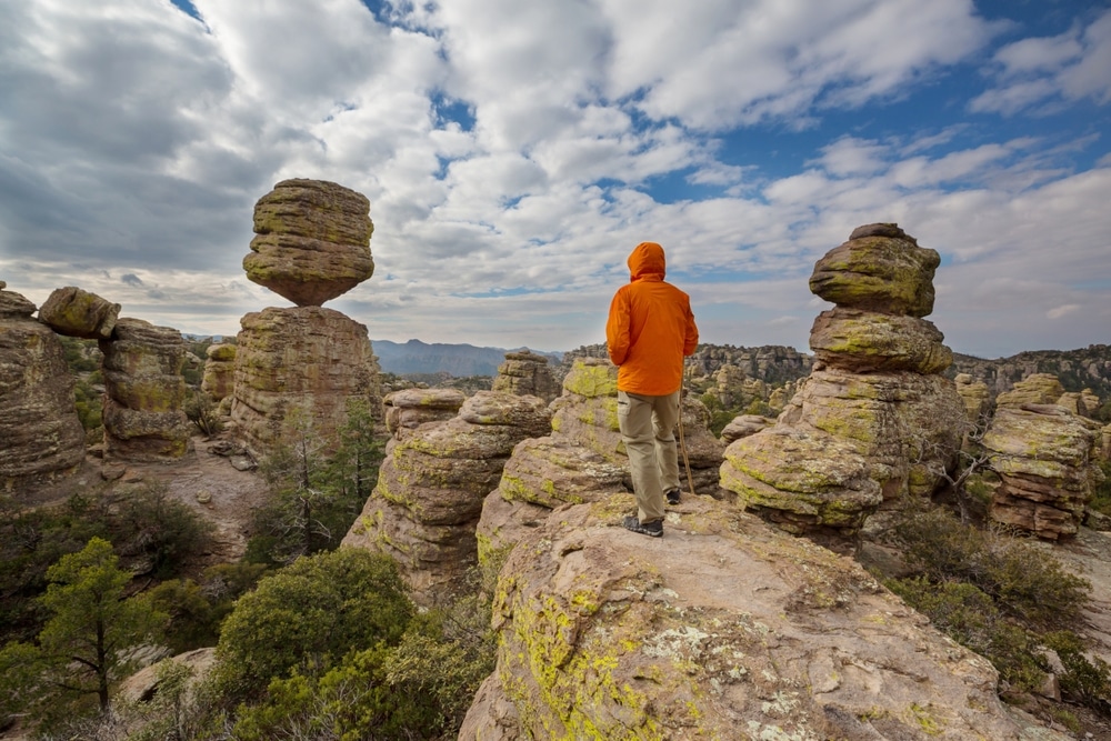
For an easy introduction to the monument, the Echo Canyon Trail is a popular choice. This 3.3-mile loop takes visitors through narrow passageways, past towering rock pinnacles, and into shaded groves. The Heart of Rocks Loop, a 7.3-mile round-trip hike, showcases the monument’s most iconic formations, such as Big Balanced Rock, Duck on a Rock, and Pinnacle Balanced Rock. For those seeking a shorter walk, the Massai Point Nature Trail offers a half-mile loop with panoramic views of the “Wonderland of Rocks.”
More adventurous hikers can explore the Rhyolite Canyon Trail, a 9.5-mile out-and-back route that takes you deep into the monument’s rugged wilderness. Along any trail, you’ll encounter stunning volcanic rock formations, dramatic vistas, and diverse plant and animal life.

The Bonita Canyon Campground is the only developed campground in the monument, offering 25 sites nestled among shady oak and sycamore trees. The campground is open year-round and accommodates tents and smaller RVs (up to 29 feet). Each site includes a picnic table and fire ring, but there are no hookups available. Reservations are recommended, especially during the spring and fall, which are the most popular seasons to visit.
Camping here allows for easy access to the monument’s trails and a peaceful night under the stars, surrounded by the quiet beauty of the Chiricahua Mountains.

The National Park Service offers a variety of ranger-led programs throughout the year. These include guided hikes, talks, and evening programs that delve into the geology, wildlife, and cultural history of Chiricahua National Monument. Check the visitor center for schedules and availability during your visit.

The Chiricahua Mountains have a long human history, and the monument preserves much of this cultural heritage. The area was once home to the Chiricahua Apache, including the legendary leader Cochise and the warrior Geronimo. The rugged terrain served as a homeland and stronghold for the Apache people for centuries.
In the late 1800s, the Swedish immigrant Erickson family settled in the area and established the Faraway Ranch, which became a guest ranch in the early 20th century. Today, visitors can tour the Faraway Ranch Historic District, which includes the restored ranch house and surrounding buildings. The ranch tells the story of early settlers and their efforts to adapt to the remote wilderness.

Chiricahua National Monument’s diverse ecosystems, which range from desert scrub to pine forests, support a rich variety of wildlife. Keep an eye out for white-tailed deer, javelinas, and coatimundis, a raccoon-like mammal native to the region. The monument is also home to over 200 species of birds, including the colorful painted redstart, Mexican jay, and elegant trogon. Early mornings and evenings are the best times for wildlife viewing.
Wupatki National Monument is part of a designated International Dark Sky Park, making it an exceptional spot for stargazing. On clear nights, visitors can witness a brilliant display of stars, planets, and even the Milky Way galaxy.

The Bonita Canyon Drive is a paved, 8-mile road that takes visitors through the heart of Chiricahua National Monument. The drive climbs gradually to Massai Point, which offers breathtaking views of the surrounding rock formations and valleys. Along the way, there are pullouts and picnic areas where you can stop to admire the scenery or access trailheads.
| Category | Details |
|---|---|
| Location | Southeastern Arizona, USA |
| Established | April 18, 1924 |
| Managed by | National Park Service (NPS) |
| Area | Approximately 12,025 acres |
| Primary Features | Unique rhyolite rock formations, known as “standing up rocks,” created by volcanic activity millions of years ago |
| Nearest Cities | Willcox, Arizona |
| Activities | Hiking, wildlife viewing, birdwatching, photography, camping, and ranger-led programs |
| Topography | High desert landscape with dramatic rock pinnacles, deep canyons, and forested areas |
| Popular Attractions | – Echo Canyon Trail: A scenic hike through narrow canyons and towering rock spires – Massai Point: A panoramic viewpoint – Faraway Ranch: A historic homestead showcasing pioneer history |
| Wildlife | Coatis, black bears, white-tailed deer, mountain lions, and over 200 bird species, including elegant trogons |
| Vegetation | Oak, juniper, and pine forests at higher elevations, desert grasses, and wildflowers |
| Climate | Semi-arid with warm summers, mild winters, and seasonal monsoon rains |
| Wilderness Area | Over 85% of the monument is designated as wilderness |
| Visitor Center | Chiricahua National Monument Visitor Center, which provides maps, exhibits, and park information |
| Camping | Bonita Canyon Campground (25 sites, no hookups, reservations recommended) |
| Significance | Known as the “Wonderland of Rocks,” the monument protects stunning geologic formations and preserves the cultural history of Apache and early settlers |
| Website | Chiricahua National Monument – National Park Service |
This unique positioning has created a biological diversity that rivals the monument’s geological complexity. From desert cacti to alpine conifers, from coatimundis to elegant trogons, Chiricahua supports an astonishing array of plant and animal species within its relatively modest boundaries. The monument also preserves a rich cultural history, from ancient indigenous peoples to frontier settlers and the legendary Apache leader Geronimo, who was born in this region.
For visitors, Chiricahua offers a remarkable combination of accessible recreation and pristine wilderness, all within a few hours’ drive of major urban centers like Tucson and Phoenix. Whether exploring its extensive trail network, marveling at panoramic vistas, or simply seeking solitude among the stone columns, Chiricahua National Monument provides an unforgettable window into the natural and cultural heritage of the American Southwest.
The story of Chiricahua’s distinctive landscape begins approximately 27 million years ago with the cataclysmic eruption of the Turkey Creek Caldera. This massive volcanic event ejected over 100 cubic miles of ash and pumice across the region—a volume hundreds of times greater than the 1980 eruption of Mount St. Helens. As this superheated material settled and cooled, it compressed into a rock type known as rhyolite tuff, characterized by its high silica content and relatively soft texture.
The Turkey Creek eruption deposited layers of ash up to 2,000 feet thick in some areas. This formation, known as the Rhyolite Canyon Tuff, provides the primary canvas upon which erosion would later create the monument’s fantastic features. Geologists can identify at least six distinct eruption events in the layers visible throughout the monument, each with slightly different mineral compositions that weather at different rates.
The transformation from massive ash deposit to today’s wonderland of rock formations required millions of years of persistent erosion. Several key processes contributed to this remarkable sculpting:
Vertical Jointing: As the volcanic ash cooled and compressed, it developed vertical fractures or joints. These natural fault lines provided pathways for water to penetrate the rock.
Freeze-Thaw Cycles: Water seeping into these cracks expanded when frozen, gradually widening the fractures through countless seasonal cycles.
Chemical Weathering: Acidic rainwater slowly dissolved certain minerals in the rock, weakening its structure over time.
Mechanical Weathering: Wind, rain, and temperature fluctuations continuously wore away the softer portions of the rock, while more resistant sections remained.
Differential Erosion: Variations in the density and mineral composition of the rhyolite tuff caused some areas to erode more quickly than others, creating the irregular and fantastical shapes visible today.
The monument contains several distinctive types of rock formations, each with characteristic shapes and formation processes:
Balanced Rocks: These precariously perched boulders appear to defy gravity, having been eroded at their bases while maintaining enough contact to remain upright. Big Balanced Rock is one of the monument’s most photographed features.
Hoodoos: Tall, thin spires of rock with a harder cap rock protecting the softer material below. As erosion continues, these may eventually become balanced rocks when sufficiently undercut.
Columns: Vertical shafts formed when erosion works along parallel sets of joints in the rhyolite. The Heart of Rocks area contains many excellent examples, including those whimsically named “Duck on a Rock” and “Thor’s Hammer.”
Wall Formations: Thin, fin-like structures created when erosion carves away material between two parallel vertical joints.
Grottos and Caves: Shallow cavities formed where differential weathering has excavated softer material beneath more resistant rock.
These formations continue to evolve today, though at a pace imperceptible to human observation. Occasional rockfalls and collapses dramatically remind visitors that this landscape remains in a state of slow but constant transformation.
Chiricahua National Monument’s location at the convergence of multiple ecological zones has earned it recognition as one of the most biologically diverse areas in the American Southwest. The monument spans elevations from approximately 5,100 feet at the entrance station to 7,310 feet at Massai Point, creating distinct life zones that support different plant and animal communities.
This region is part of the larger “Sky Island” phenomenon, where isolated mountain ranges rise from the surrounding desert like islands from an ocean, creating habitats that differ dramatically from the surrounding lowlands. The isolation of these mountain habitats has led to unique evolutionary adaptations and remarkable species diversity.
The plant communities within Chiricahua reflect its position at the intersection of multiple ecological zones:
Desert Scrub Zone: At lower elevations, particularly on south-facing slopes, desert-adapted species predominate, including various cacti, agave, yucca, and drought-resistant shrubs.
Oak Woodland Zone: The mid-elevations feature extensive oak woodlands, with several species including Emory oak, silverleaf oak, and Arizona white oak. These areas also support manzanita, mountain mahogany, and a variety of flowering plants.
Pine-Oak Forest Zone: Higher elevations and north-facing slopes support Apache pine, Chihuahua pine, and ponderosa pine intermingled with oak species. The understory here includes grasses, ferns, and flowering plants that require more moisture.
Riparian Communities: Along seasonal and permanent watercourses, distinctive riparian vegetation thrives, including Arizona sycamore, velvet ash, and various willows. These areas represent crucial habitat for many animal species.
The monument is also known for its spectacular wildflower displays following the summer monsoon rains, when the normally austere landscape erupts with color from penstemons, columbines, lupines, and dozens of other flowering species.
The diverse habitats within Chiricahua support an equally impressive array of animal species:
Mammals: The monument is home to approximately 71 mammal species, including mule deer, white-tailed deer, javelina, black bears, mountain lions, bobcats, coatimundis, ringtails, and several bat species. The white-nosed coati, a tropical species that reaches the northern limit of its range here, is a particular highlight for wildlife enthusiasts.
Birds: With over 200 documented bird species, Chiricahua is renowned among birdwatchers. The monument provides habitat for the elegant trogon, Mexican jay, acorn woodpecker, bridled titmouse, painted redstart, and numerous hummingbird species. The canyons also serve as a critical migratory corridor for birds traveling between their summer and winter ranges.
Reptiles and Amphibians: Approximately 60 species of reptiles and amphibians have been documented, including the twin-spotted rattlesnake, rock rattlesnake, Sonoran mountain kingsnake, collared lizard, and several species of spiny lizards. After summer rains, canyon pools may host spadefoot toads, leopard frogs, and tiger salamanders.
Invertebrates: The monument is particularly rich in butterfly and moth species, with more than 180 documented varieties. Numerous other insect species play vital roles in pollination and form the base of the food web that supports larger animals.
The biological richness of Chiricahua shifts dramatically with the seasons:
Spring (March-May): As temperatures warm, plants begin to green up, and early wildflowers appear. Bird activity increases as migratory species return and nesting begins.
Summer (June-September): The arrival of the monsoon season (typically July-September) triggers a biological explosion, with dormant plants leafing out, wildflowers blooming, and amphibians emerging. This is also when coatimundis are most commonly observed.
Fall (October-November): Cooler temperatures bring subtle fall colors to the oak woodland, along with increased activity from deer and other mammals preparing for winter.
Winter (December-February): While the higher elevations may receive occasional snow, the lower areas remain accessible and provide good opportunities to observe resident bird species and winter visitors. The bare trees also improve visibility for wildlife watching.
The Chiricahua Mountains and surrounding areas have significant cultural importance as part of the traditional homeland of the Chiricahua Apache. For centuries before European contact, Apache bands moved seasonally throughout this region, utilizing its diverse resources for subsistence. The mountains provided not only food and materials but also strategic advantages and spiritual significance.
The most famous Apache associated with this region is Geronimo (Goyathlay), who was born near the present-day monument around 1829. The rugged terrain of the Chiricahua Mountains served as a natural fortress for Apache resistance against Mexican and American military forces during the late 19th century. The name “Chiricahua” itself comes from the Apache word for the mountain range, though its precise meaning is debated among linguists and historians.
European and American settlers began entering the region in significant numbers after the 1854 Gadsden Purchase transferred this part of Arizona from Mexico to the United States. The discovery of minerals in the surrounding mountains brought miners to the area, while cattlemen established ranches in the fertile valleys.
One of the most significant early European settlements was the Stafford cabin, built around 1880 by Ja Hu Stafford, a miner who later turned to ranching. This historic structure, now preserved within the monument, provides visitors with a tangible connection to the frontier era.
The establishment of Fort Bowie in 1862, about 20 miles northeast of present-day Chiricahua National Monument, marked the U.S. military’s permanent presence in the region. This fort served as the base for operations against the Apache until their eventual surrender in the 1880s.
The unique rock formations of Chiricahua first gained national attention in the late 19th century, attracting geologists, naturalists, and tourists. Early advocates for protection included local residents Neil and Emma Erickson, Swedish immigrants who established the Faraway Ranch in 1887 adjacent to what would become the monument. Their daughter, Lillian Erickson Riggs, and her husband, Ed Riggs, later developed the property into a guest ranch that introduced many visitors to the area’s spectacular scenery.
Ed Riggs played a crucial role in the development of the monument, advocating for its protection and designing many of the trails that still serve visitors today. His intimate knowledge of the area’s topography allowed him to create routes that maximize scenic experiences while respecting the landscape’s natural features.
Chiricahua was proclaimed a national monument by President Calvin Coolidge on April 18, 1924, specifically to protect its “extraordinary examples of weathering and erosion in the forms of pinnacles and balanced rocks.” Initially, it encompassed just over 4,000 acres, with subsequent expansions bringing it to its current size.
The Great Depression brought the Civilian Conservation Corps (CCC) to Chiricahua from 1934 to 1940. CCC workers constructed much of the infrastructure that remains in use today, including roads, trails, buildings, and the impressive stone bridge at Bonita Creek. Their craftsmanship is especially evident in the monument’s visitor center and administration building, constructed from local stone in a rustic architectural style that harmonizes with the natural surroundings.
In 1979, approximately 87% of Chiricahua National Monument (10,290 acres) was designated as wilderness under the National Wilderness Preservation System, providing additional protection for its natural resources and ensuring that a majority of the monument will remain undeveloped.
The Faraway Ranch, operated by the Erickson-Riggs family until the 1970s, was acquired by the National Park Service in 1979 and is now preserved as a historic site within the monument. Guided tours of the ranch buildings offer visitors insights into pioneer life and early tourism development in the region.
In recent decades, the monument has faced challenges from climate change, invasive species, and the increasing frequency of wildfires. The 2011 Horseshoe Two Fire burned approximately 80% of the monument, altering forest composition and creating ongoing management challenges. Despite these challenges, Chiricahua National Monument continues to protect its extraordinary geological features and biological diversity while providing opportunities for education and recreation.
The monument’s 8-mile Bonita Canyon Drive provides access to major viewpoints and trailheads while offering spectacular scenery for those with limited time or mobility. This paved road climbs from the entrance station at 5,400 feet to Massai Point at 6,870 feet, featuring numerous pullouts and interpretive displays along the way.
The highlight of this scenic drive is the view from Massai Point, where visitors can enjoy a 360-degree panorama encompassing the monument’s dramatic rock formations, surrounding mountain ranges, and vast desert basins. On clear days, visibility can extend over 100 miles into New Mexico and Mexico.
With over 17 miles of well-maintained trails, Chiricahua offers hiking experiences ranging from easy nature walks to challenging backcountry adventures. The trail system is interconnected, allowing for numerous loop options and the ability to customize hikes according to interest and ability:
Massai Point Nature Trail: A paved, accessible 0.5-mile loop providing spectacular views and interpretive information about the monument’s geology and ecology.
Echo Canyon Loop: A moderate 3.3-mile circuit descending through some of the monument’s most photogenic formations, including Wall Street and Echo Canyon Grotto.
Heart of Rocks Loop: A strenuous but rewarding 1.1-mile loop (accessible only as part of longer hikes) showcasing the monument’s most famous balanced rocks and named formations like “Duck on a Rock,” “Thor’s Hammer,” and “Punch and Judy.”
Big Loop: An ambitious 9.5-mile circuit combining several trails to provide a comprehensive experience of the monument’s diverse environments and formations.
Natural Bridge Trail: A moderate 4.8-mile round-trip to a small limestone natural bridge in the monument’s northeastern section, offering different geology and ecosystems than the rhyolite formations.
Faraway Ranch Trail: An easy 1-mile round-trip connecting the visitor center with the historic Faraway Ranch, featuring riparian habitat along Bonita Creek.
Most trails in the monument were originally designed and constructed by Ed Riggs and later improved by the Civilian Conservation Corps, incorporating natural rock steps, switchbacks, and occasionally tunnels through rock formations. This historical trail engineering adds to the visitor experience while minimizing environmental impact.
Chiricahua’s reputation as a premier destination for wildlife observation, particularly bird watching, draws naturalists from around the world. The monument’s location at the convergence of several ecological zones creates habitats for species not commonly found elsewhere in the United States.
Bonita Creek, near the visitor center and campground, offers excellent bird watching opportunities year-round, with its permanent water source and lush riparian vegetation. Early morning hours typically provide the best wildlife viewing conditions, though certain species are more active at dusk.
The annual Southwest Wings Birding Festival, held in nearby Sierra Vista, often includes field trips to Chiricahua National Monument, highlighting its importance in the regional birding community.
The monument’s extraordinary rock formations, dramatic lighting conditions, and diverse wildlife provide endless opportunities for photography enthusiasts:
Morning light: The eastern exposure of many formations makes them particularly photogenic during the golden hours after sunrise, when the first light illuminates the rhyolite columns with warm tones.
Afternoon thunderstorms: During monsoon season, dramatic cloud formations and lightning create spectacular backdrops for landscape photography.
Seasonal highlights: Spring wildflowers, summer thunderclouds, fall colors in the oak woodlands, and occasional winter snow each offer distinctive photographic opportunities.
Popular photography locations include the balanced rocks in the Heart of Rocks area, the dramatic walls of Echo Canyon, and the panoramic vistas from Massai Point and Sugarloaf Mountain.
Chiricahua’s remote location, high elevation, and clear air make it an excellent destination for night sky observation. With minimal light pollution, especially compared to Arizona’s urban areas, the monument offers spectacular views of stars, planets, and the Milky Way.
The National Park Service occasionally offers ranger-led astronomy programs during the summer months, taking advantage of the excellent viewing conditions from Massai Point or the campground amphitheater.
Developed picnic areas with tables, grills, and restrooms are available at the visitor center and Massai Point, offering convenient facilities for day visitors. The Massai Point picnic area, with its panoramic views and higher elevation, provides a particularly pleasant setting during hot summer months.
Chiricahua National Monument is located in the southeastern corner of Arizona, approximately:
The monument is accessed via Arizona State Highway 186, which connects to Interstate 10 at Willcox. The final 8 miles to the monument entrance is via Arizona State Highway 181. Both roads are paved and maintained year-round, though winter storms occasionally cause temporary closures.
No public transportation serves the monument directly. The closest commercial airports are in Tucson and Phoenix, where rental vehicles are available.
The Chiricahua National Monument Visitor Center, located near the entrance, operates daily from 8:30 AM to 4:30 PM (hours may vary seasonally). Facilities include:
Additional facilities within the monument include:
Cell phone coverage is limited or nonexistent within the monument. Public Wi-Fi is not available, and visitors should plan accordingly.
Bonita Creek Campground provides the only overnight accommodations within the monument. This small, wooded campground features:
The campground operates on a first-come, first-served basis, except for the group site, which requires advance reservation. Sites typically fill by mid-afternoon during peak spring and fall seasons. The camping fee is $20 per night (subject to change).
Alternative camping options include:
For those seeking lodging, options include:
Chiricahua experiences distinct seasons that significantly affect visitor experiences:
Spring (March-May): Generally mild and pleasant temperatures, with daytime highs averaging 60-80°F and overnight lows in the 40-50°F range. Occasional strong winds can occur. Wildflowers typically begin blooming in late March or April.
Summer (June-September): Characterized by hot days with temperatures reaching 85-95°F, though the higher elevations remain cooler than surrounding desert areas. The monsoon season (July-September) brings afternoon thunderstorms, spectacular cloud formations, and occasional flash floods. Morning hiking is recommended to avoid afternoon heat and thunderstorms.
Fall (October-November): Arguably the most pleasant season, with mild temperatures, clear skies, and minimal precipitation. Daytime temperatures typically range from 60-75°F, with cooler nights. Fall color in the oak woodlands typically peaks in late October to early November.
Winter (December-February): Generally mild during daylight hours (45-60°F) but cold at night, often dropping below freezing. Snow is possible at the monument’s higher elevations, occasionally closing Bonita Canyon Drive temporarily. Winter visitors should check road conditions before traveling and be prepared for cold temperatures, especially overnight.
Year-round, visitors should be aware that temperatures can vary significantly between the entrance station and Massai Point due to the 1,500-foot elevation difference. Layered clothing is recommended in all seasons.
The combination of rugged terrain, remote location, and variable weather at Chiricahua creates several safety considerations for visitors:
Hydration: Even in cooler weather, the arid environment causes rapid fluid loss. Visitors should carry at least one gallon of water per person per day when hiking, and more during hot weather.
Sun Protection: The high elevation increases UV exposure. Sunscreen, hats, sunglasses, and protective clothing are essential even on cloudy days.
Lightning Safety: During monsoon season, afternoon thunderstorms create dangerous lightning conditions, particularly at exposed viewpoints and along ridgelines. Visitors should plan to be off high trails by early afternoon during monsoon season and seek shelter in vehicles or buildings (not under trees) if thunderstorms approach.
Flash Flood Awareness: The monument’s canyons can experience dangerous flash flooding during heavy rain, even when the sky is clear overhead. Visitors should avoid canyon bottoms during thunderstorms and be aware of escape routes.
Wildlife Encounters: While attacks are extremely rare, visitors should maintain a safe distance from wildlife. Snake encounters are possible on warm days; hikers should stay on trails, watch where they step and place their hands, and never harass or attempt to handle reptiles.
Navigation: While the monument’s trails are generally well-marked, hikers should carry a map and be aware of their location, particularly when combining multiple trails for longer hikes.
Medical Facilities: No medical services are available within the monument. The nearest hospital is in Willcox, approximately 36 miles away. Serious emergencies may require helicopter evacuation.
Chiricahua National Monument charges an entrance fee of $10 per vehicle, valid for seven days. Annual passes are available for $35, and National Park Service passes (America the Beautiful Pass, Senior Pass, Access Pass, etc.) are also accepted.
No special permits are required for day hiking or picnicking within the monument. Backcountry camping is not permitted within monument boundaries, though it is allowed in the adjacent Chiricahua Wilderness in Coronado National Forest with appropriate permits.
Commercial photography, filming, or organized group activities may require special permits. Interested parties should contact monument administration well in advance.
Chiricahua National Monument faces several significant conservation challenges:
Fire Management: Historically, frequent low-intensity fires maintained open forest conditions. Decades of fire suppression, followed by recent high-intensity wildfires like the 2011 Horseshoe Two Fire, have dramatically altered forest composition and structure. The National Park Service now implements prescribed burns and mechanical thinning to reduce fuel loads and restore healthier forest conditions.
Invasive Species: Non-native plants such as buffelgrass and Lehmann lovegrass threaten to displace native vegetation and alter fire regimes. Invasive animals, including bullfrogs and feral hogs, compete with native species for resources.
Climate Change: Rising temperatures and changing precipitation patterns are affecting the monument’s ecosystems, potentially causing shifts in species distribution and increasing drought stress on vegetation. More extreme weather events, including floods and extended droughts, present additional management challenges.
Water Resources: The long-term sustainability of Bonita Creek and other water sources within the monument is increasingly uncertain due to regional drought conditions and groundwater pumping in surrounding areas.
Visitation Impacts: While visitation numbers at Chiricahua remain moderate compared to more accessible national parks, concentrated use along trails and at popular viewpoints creates localized impacts that require ongoing mitigation.
The National Park Service maintains several active research and monitoring programs at Chiricahua, often in partnership with universities and other scientific institutions:
Fire Ecology: Studies of vegetation recovery following the 2011 Horseshoe Two Fire provide valuable data for future management decisions.
Wildlife Surveys: Regular inventories of bird, mammal, reptile, and invertebrate populations help track changes over time and identify species of conservation concern.
Climate Monitoring: Weather stations within the monument contribute to regional climate databases and help document changing conditions.
Historical and Archaeological Research: Ongoing investigations continue to reveal new information about the monument’s human history and prehistoric use.
These research efforts not only inform management decisions but also contribute to broader scientific understanding of Sky Island ecosystems and their response to environmental changes.
Visitors to Chiricahua National Monument can contribute to conservation efforts through responsible practices:
The National Park Service offers various volunteer opportunities at Chiricahua, including:
Information about current volunteer opportunities is available at the visitor center or on the monument’s official website.
Chiricahua National Monument is surrounded by Coronado National Forest, which offers additional recreational opportunities and different management approaches:
Chiricahua Wilderness: This 87,700-acre wilderness area directly adjacent to the monument provides more remote backcountry experiences with fewer developed facilities.
Cave Creek Canyon: Located near Portal, this renowned birding destination offers different habitats and species than those found within the monument.
Dragoon Mountains: West of Chiricahua, these rugged mountains offer rock climbing, hiking, and historical connections to Cochise and the Apache resistance.
Visitors to Chiricahua may want to include other regional attractions in their itinerary:
Fort Bowie National Historic Site: Located approximately 30 miles northeast of Chiricahua, this preserved frontier military post interprets the conflict between the U.S. Army and the Chiricahua Apache.
Cochise Stronghold: A natural fortress in the Dragoon Mountains where the Apache leader Cochise and his band successfully eluded capture.
Kartchner Caverns State Park: A spectacular living limestone cave system with guided tours, located approximately 80 miles west of Chiricahua.
Historic towns: Bisbee, Tombstone, and Douglas offer distinctive experiences of Arizona’s mining, ranching, and frontier history.
The protection of the greater Chiricahua ecosystem involves collaboration among multiple agencies and organizations:
These partnerships recognize that the long-term preservation of Chiricahua’s natural and cultural values depends on ecosystem-wide approaches that transcend administrative boundaries.
Chiricahua National Monument represents a masterpiece of natural sculpture, a biological treasure house, and a landscape rich with cultural significance. Its balanced rocks and soaring spires not only inspire wonder and delight but also tell a complex geological story spanning millions of years. Its diverse habitats support an extraordinary array of plant and animal species, making it a living laboratory for understanding the unique ecology of the Sky Island region.
From the Chiricahua Apache who called these mountains home to the pioneers who first settled here, from the early advocates who secured its protection to the modern visitors who discover its wonders, Chiricahua has played a meaningful role in human experience for centuries. Today, the monument continues this tradition by providing opportunities for recreation, education, and spiritual renewal in a landscape of uncommon beauty.
As climate change, invasive species, wildfire, and other pressures create new challenges for this fragile ecosystem, the mission of Chiricahua National Monument becomes increasingly important. Through thoughtful management, scientific research, and public stewardship, this extraordinary landscape can continue to thrive, inspiring generations of visitors while preserving its geological wonders and biological diversity.
For those willing to venture off the beaten path to this southeastern corner of Arizona, Chiricahua National Monument offers something increasingly rare in our modern world: a place where natural processes remain the dominant force, where human presence is a temporary privilege rather than a permanent imprint, and where the scale and creativity of geological time remind us of our own brief but meaningful place in the larger patterns of the natural world.
We use cookies to improve your experience on our site. By using our site, you consent to cookies.
Manage your cookie preferences below:
Essential cookies enable basic functions and are necessary for the proper function of the website.