In the far northern reaches of Arizona, where the Colorado Plateau stretches toward the Utah border, lies one of America’s most spectacular yet least-visited treasures: Vermilion Cliffs National Monument. Established in 2000 by Presidential Proclamation, this 280,000-acre expanse of rugged wilderness preserves some of the most visually stunning geological formations in the American Southwest. Rising as much as 3,000 feet above the surrounding desert, the monument’s namesake cliffs form an immense escarpment of multicolored sandstone layers that glow with intense red, orange, and yellow hues in the changing light of day.
This remote protected area represents a remarkable intersection of geological wonder, ecological significance, and cultural heritage. The landscape has been sculpted over millions of years by the persistent forces of wind and water, creating a mesmerizing array of slot canyons, towering plateaus, natural arches, and fantastical rock formations that seem to defy gravity and imagination alike. Beyond its geological significance, the monument hosts diverse desert ecosystems and serves as critical habitat for endangered species, including the California condor, which was reintroduced to the region in the late 1990s.
For outdoor enthusiasts and wilderness seekers, Vermilion Cliffs offers a rare combination of extraordinary natural beauty and genuine solitude. Unlike many of Arizona’s more accessible public lands, this monument remains relatively uncrowded, providing visitors with an authentic wilderness experience. However, this remoteness also demands careful preparation, respect for the fragile environment, and a spirit of self-reliance from those who venture to explore its wonders.
This guide aims to provide comprehensive information about Vermilion Cliffs National Monument, including its most notable features, recreational opportunities, practical visitor information, and conservation considerations. Whether you’re planning a visit or simply seeking to understand and appreciate this remarkable landscape from afar, the following pages will illuminate what makes Vermilion Cliffs one of Arizona’s most extraordinary public lands.
Paria Canyon offers a unique hiking experience through narrow slot canyons, towering cliffs, and sandy riverbeds. The multi-day Paria Canyon backpacking route is a favorite for adventurers, leading through some of the most remote and scenic areas of the monument. Permits are required for overnight trips.
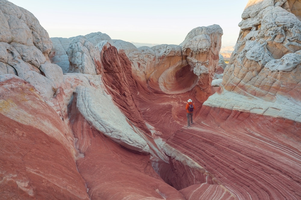
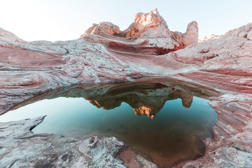
White Pocket is a lesser-known but equally stunning area within the monument. Its otherworldly rock formations, swirls of white and orange sandstone, and intricate textures make it a photographer’s dream. White Pocket is more accessible than The Wave and does not require a permit, but a high-clearance, 4WD vehicle is necessary to reach it.
The towering Vermilion Cliffs, which rise up to 3,000 feet, are the monument’s namesake and a sight to behold. These colorful cliffs showcase layers of red, orange, and white rock, shaped by millions of years of erosion. You can view the cliffs from various vantage points along U.S. Route 89A or while exploring the monument.

The Wave is one of the most iconic and sought-after destinations in Vermilion Cliffs. This stunning sandstone formation features mesmerizing, wave-like patterns and vibrant colors. Access to The Wave is restricted to a permit system due to its fragile environment, so be sure to apply for a permit through the online lottery or walk-in lottery well in advance.

Vermilion Cliffs National Monument is part of the Colorado Plateau, known for its dark skies and incredible stargazing opportunities. Camping in the area allows you to experience the solitude of the desert and witness the Milky Way in all its glory. Be sure to camp responsibly and follow Leave No Trace principles.

The stunning landscapes of Vermilion Cliffs make it a paradise for photographers. Whether it’s the vibrant colors of The Wave, the intricate patterns of White Pocket, or the towering Vermilion Cliffs themselves, the monument provides endless opportunities for capturing the natural beauty of the Southwest.

Buckskin Gulch is one of the longest and most famous slot canyons in the world. This challenging hike takes you through narrow, winding passages with towering walls on either side. It can be done as a day hike or as part of a longer trek into Paria Canyon, but be prepared for flash floods and other hazards.

Despite its desert environment, Wupatki is home to a variety of wildlife, including pronghorn antelope, jackrabbits, and birds of prey. Bring binoculars to spot animals and appreciate the biodiversity of this arid landscape.

House Rock Valley is home to a population of endangered California condors, which were reintroduced to the area in the 1990s. Visit the Condor Viewing Area at the base of the Vermilion Cliffs to catch a glimpse of these magnificent birds soaring above the canyon walls.

Drive along U.S. Route 89A or House Rock Valley Road for spectacular views of the Vermilion Cliffs and surrounding landscapes. These scenic routes offer plenty of opportunities to stop and admire the beauty of the area. Keep in mind that some roads require 4WD and are best navigated in dry conditions.

The monument’s unique landscapes are the result of millions of years of geological processes, including erosion, sedimentation, and tectonic activity. Additionally, the area is rich in human history, with evidence of Native American habitation, including petroglyphs and ancient artifacts.
| Category | Details |
|---|---|
| Location | Northern Arizona, near the Utah border, USA |
| Established | November 9, 2000 |
| Managed By | Bureau of Land Management (BLM) |
| Size | Approximately 293,689 acres (118,889 hectares) |
| Main Attractions | The Wave, Coyote Buttes, Paria Canyon, Buckskin Gulch, White Pocket |
| Cultural Significance | Features ancient petroglyphs and evidence of prehistoric human habitation. |
| Geology | Dramatic sandstone cliffs, slot canyons, and colorful rock formations |
| Ecosystem | High desert with unique flora and fauna, including desert bighorn sheep |
| Nearby Landmarks | Grand Canyon, Glen Canyon, and Antelope Canyon |
| Visitor Activities | Hiking, photography, camping, backpacking, and wildlife viewing |
| Special Permit Areas | The Wave (Coyote Buttes North) and Coyote Buttes South require permits due to limited access |
| Climate | Hot summers, mild winters, and limited rainfall |
| Entrance Fee | No general entrance fee, but permits are required for certain areas |
| Accessibility | Remote and rugged; many areas are inaccessible by paved roads |
| Fun Fact | The Wave is one of the most photographed natural rock formations in the world. |
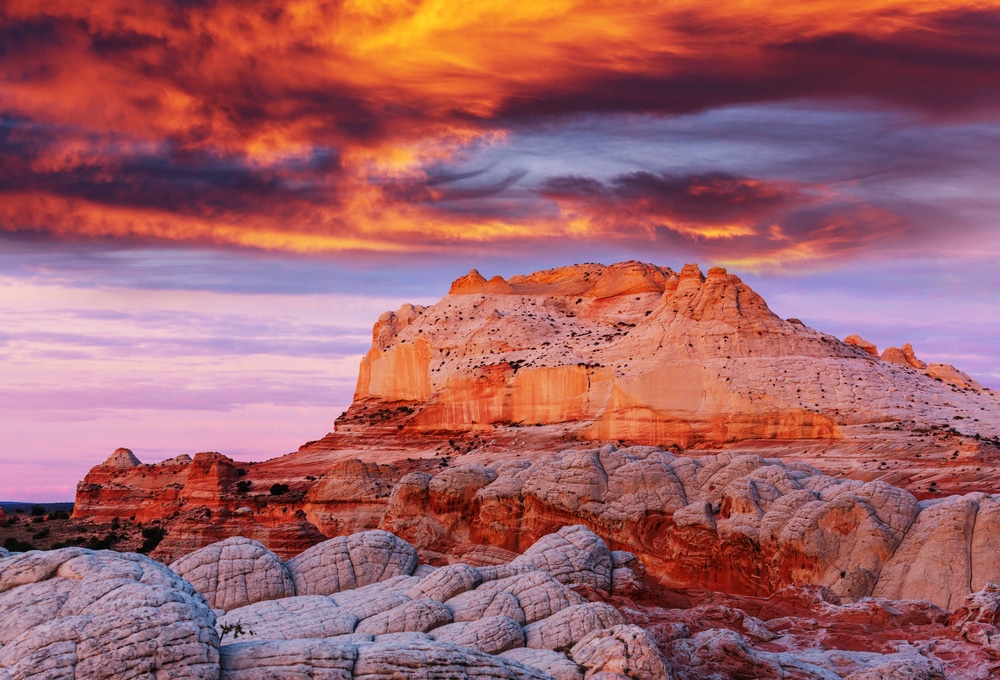
The monument’s defining feature is the massive escarpment known as the Vermilion Cliffs, which rise dramatically from the surrounding desert floor. These cliffs represent the southern edge of the Paria Plateau, a vast tableland that comprises most of the monument’s territory. The cliffs themselves are composed of layers of sandstone, siltstone, limestone, and shale deposited over hundreds of millions of years when the region was alternately covered by ancient seas, rivers, lakes, and sand dunes.
The vibrant red colors that give the cliffs their name come from iron oxide minerals in the sandstone, while variations in mineral content create the distinctive banded appearance. The cliffs’ sheer faces, some towering more than 2,000 feet high, showcase approximately 600 million years of geological history. Viewed from Highway 89A, which runs along their base, the Vermilion Cliffs present one of the most spectacular geological exposures in North America.
The eastern portion of the monument contains Paria Canyon, a serpentine gorge carved by the Paria River as it flows toward the Colorado River. Stretching for 38 miles, this canyon is renowned for its colorful walls that narrow to just a few feet wide in some sections, creating one of the premier slot canyon experiences in the Southwest. The canyon begins at White House Trailhead in Utah and terminates at Lee’s Ferry in Arizona, where the Paria River joins the Colorado.
Hiking through Paria Canyon offers an intimate experience with geological processes, as visitors witness firsthand how flowing water has sculpted the soft sandstone into smooth, undulating forms. The canyon walls display “desert varnish” – dark mineral stains created over centuries as manganese and iron oxides gradually accumulate on the rock surface. Numerous springs emerge from the canyon walls, creating oases of verdant growth and welcome water sources for wildlife and hikers alike.
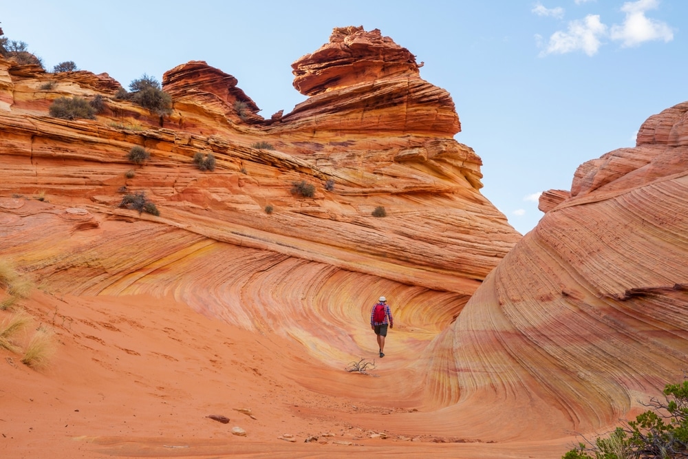
Perhaps the most famous feature within Vermilion Cliffs National Monument is “The Wave,” a spectacular sandstone formation located in the Coyote Buttes North area. This otherworldly landscape consists of undulating layers of sandstone that have been eroded into a series of troughs and ridges, creating the appearance of a frozen wave. The rock displays striking bands of red, yellow, orange, and white, which follow the contours of the formation to create a mesmerizing swirled pattern.
Due to its fragility and international fame, access to The Wave is strictly limited to just 64 visitors per day (up from the previous 20 per day) through a competitive permit system. This protection ensures that the delicate sandstone formations remain intact for future generations while also preserving the wilderness experience for those lucky enough to obtain permits.
Beyond The Wave, the larger Coyote Buttes area contains numerous other remarkable formations, including:
The Second Wave: A similar but less visited formation with distinctive swirling patterns
The Alcove: A large, bowl-shaped depression in the sandstone
Top Rock: A balanced rock formation perched atop a sandstone hill
Melody Arch and the Grotto: A natural arch with an adjacent depression that creates interesting acoustic effects
Dinosaur Tracks: Fossilized footprints from prehistoric reptiles preserved in the ancient sandstone
Coyote Buttes South, which requires a separate permit but is somewhat easier to obtain, offers similarly spectacular scenery with fewer visitors, including the “Cottonwood Teepees” – cone-shaped formations striped with vibrant colors.
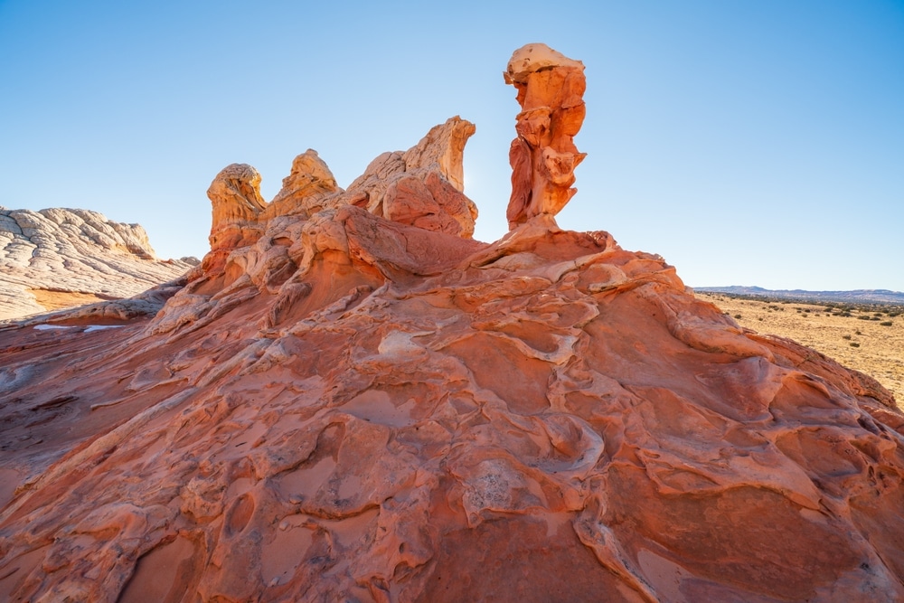
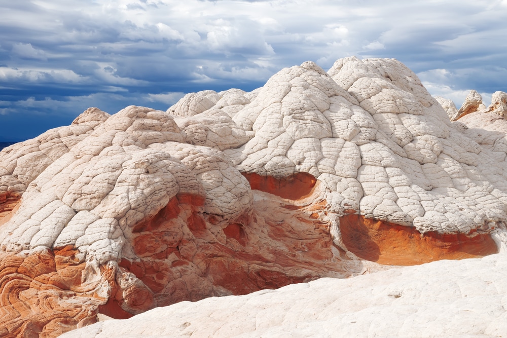
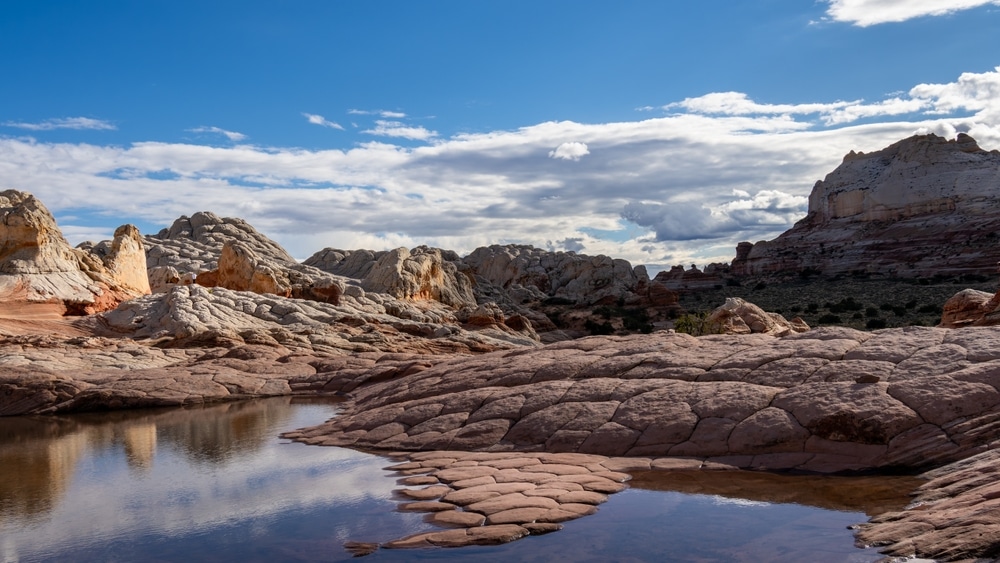
In recent years, White Pocket has emerged as an alternative destination for visitors unable to secure permits for The Wave. Located in a remote section of the monument, this area features bizarre, brain-like rock formations composed of white and cream-colored Navajo Sandstone, swirled with ribbons of pink, red, and orange. The landscape resembles a geological wonderland of domes, ridges, pockets, and hoodoos that appear almost alien in their otherworldliness.
Unlike The Wave, White Pocket does not require a permit, though its remote location and the challenging access route serve as natural limitations on visitation. Reaching White Pocket typically requires a high-clearance 4WD vehicle capable of navigating deep sand and rough roads, or alternatively, booking with one of the authorized tour operators who guide visitors to the area.
The monument contains numerous other geological highlights, including:
Buckskin Gulch: Considered the longest and deepest slot canyon in the Southwest, extending for about 15 miles with walls reaching several hundred feet high
Wire Pass: A short, narrow slot canyon that provides an alternative entry point to Buckskin Gulch
Soap Creek: A scenic side canyon with colorful rock formations
The Cockscomb: A zigzag ridge of tilted rock layers created by an ancient fault
Paria Toadstools: Mushroom-shaped rock formations created when harder caprock protects columns of softer stone from erosion
Each of these features represents a unique expression of the geological forces that have shaped this remarkable landscape over millions of years, offering visitors countless opportunities for exploration and wonder.
Hiking is the primary recreational activity at Vermilion Cliffs National Monument, offering visitors the chance to immerse themselves in its extraordinary landscapes. The monument’s hiking opportunities range from short day hikes to multi-day backpacking adventures:
Wire Pass to Buckskin Gulch: A popular day hike that leads through a narrow slot canyon to connect with the larger Buckskin Gulch. The roundtrip to the confluence and back is approximately 3.4 miles and offers an excellent introduction to slot canyon environments.
Coyote Buttes North (The Wave): For permit holders, the hike to The Wave is a moderately difficult 6-mile roundtrip across unmarked terrain. The journey requires good navigation skills, as there is no established trail, only landmarks and GPS coordinates.
White Pocket: Once you’ve navigated the challenging drive, the area can be explored via informal social trails. Most visitors spend 3-5 hours wandering among the formations.
Paria Toadstools: A relatively easy 1.5-mile roundtrip hike from Highway 89 leads to unusual hoodoo formations.
Paria Canyon: The premier backpacking destination in the monument is the 38-mile through-hike of Paria Canyon, typically completed in 3-5 days. This journey takes hikers through the entire length of the canyon from White House Trailhead to Lee’s Ferry, requiring multiple river crossings and careful planning for water sources.
Buckskin Gulch: For experienced backpackers seeking a challenging adventure, the 21-mile through-hike of Buckskin Gulch (connecting to Paria Canyon) offers one of the most immersive slot canyon experiences in the world. This demanding route requires technical skills to navigate potential obstacles including deep pools of water and log jams.
All overnight trips into Paria Canyon and Buckskin Gulch require permits from the Bureau of Land Management (BLM), which manages the monument. These permits are limited to protect the fragile ecosystem and maintain the wilderness experience.
Vermilion Cliffs National Monument has become a premier destination for landscape photographers seeking to capture its extraordinary geological features and dramatic desert light. The monument’s remote location means minimal light pollution, creating opportunities for stunning night sky photography as well.
Wildlife viewing opportunities focus primarily on bird watching, with the monument serving as habitat for numerous raptor species. The most notable wildlife program is the California condor reintroduction project. These enormous birds, with wingspans approaching 10 feet, can occasionally be spotted soaring near the cliffs. The Vermilion Cliffs are one of the few places where these critically endangered birds can be observed in the wild. The BLM occasionally hosts public condor releases, which allow visitors to witness these magnificent birds return to the wild after being raised in captivity.
Other wildlife that may be encountered includes desert bighorn sheep, pronghorn antelope, mule deer, coyotes, and various reptile species adapted to the harsh desert environment.
For those unable to hike into the monument’s more remote areas, scenic driving provides access to impressive views:
Highway 89A: This scenic byway runs along the base of the Vermilion Cliffs, offering spectacular views of the escarpment. Several pullouts allow for photography and appreciation of the massive cliff face.
House Rock Valley Road: This unpaved road runs north-south through the monument between Highways 89A and 89, passing near Coyote Buttes and offering access to various trailheads. While the first few miles are typically passable for passenger cars, the road eventually requires high-clearance vehicles, particularly after rain events.
Several authorized outfitters offer guided tours to areas within the monument, particularly to White Pocket and, for those with permits, The Wave. These tours provide transportation in appropriate vehicles, interpretation of the geology and ecology, and often photography guidance. For visitors unfamiliar with desert navigation or those without suitable vehicles, guided tours offer a safe and educational alternative to independent exploration.
Despite its seemingly harsh conditions, Vermilion Cliffs National Monument supports a surprising diversity of plant and animal life adapted to the arid environment. The monument encompasses several ecological zones determined by elevation, from desert scrubland at lower elevations to pinyon-juniper woodland on the higher plateaus.
The plant communities include:
Desert Scrub: Dominated by sagebrush, blackbrush, and various desert shrubs adapted to minimal rainfall
Riparian Areas: Along the Paria River and in canyon bottoms, cottonwood trees, willows, and various water-loving plants create green corridors
Pinyon-Juniper Woodland: At higher elevations on the Paria Plateau, drought-resistant pinyon pines and juniper trees form sparse woodlands
Specialized Plants: In the most extreme environments, specialized plants like desert trumpet, prickly pear cactus, and various lichens manage to survive
These plant communities provide habitat for a wide range of desert wildlife, including:
Birds: Over 200 species have been recorded in the monument, including golden eagles, peregrine falcons, and the endangered California condor
Mammals: Mule deer, pronghorn antelope, desert bighorn sheep, coyotes, kit foxes, jackrabbits, and numerous rodent species
Reptiles: Desert-adapted species including western rattlesnakes, Gila monsters, chuckwallas, and various lizards
Invertebrates: Numerous insect species play critical roles in pollination and as food sources for other wildlife
The monument’s varied terrain creates numerous microhabitats that support specialized ecological communities. In slot canyons, for instance, the limited sunlight and higher humidity allow for ferns, mosses, and other moisture-loving plants to grow in an otherwise arid landscape. Around springs and seeps, small oases form where wildlife congregates, particularly during the hottest months.
The plants and animals of this region display remarkable adaptations to survive the extreme conditions. Many plants have developed deep root systems, waxy coatings to reduce water loss, or the ability to remain dormant during drought periods. Animals often avoid the heat by being active at dawn, dusk, or night, and have evolved efficient water conservation mechanisms.
The monument experiences dramatic seasonal changes that affect both the landscape and visitor experience:
Moderate temperatures and occasional rainfall can trigger desert wildflower blooms, particularly in April and May. This is a popular time for hiking before summer heat arrives.
Extreme heat dominates, with temperatures regularly exceeding 100°F at lower elevations. Afternoon thunderstorms during the monsoon season (July-August) can create flash flood dangers in canyons but also produce spectacular storm photography opportunities.
Cooling temperatures make this an excellent season for hiking, with stable weather patterns and pleasant conditions. Cottonwood trees along watercourses turn golden in late October.
Cold temperatures and occasional snow affect the higher elevations of the Paria Plateau. While this creates photographic opportunities with snow contrasting against red rock, roads may become impassable, and overnight hiking can be challenging.
Vermilion Cliffs National Monument is located in remote northern Arizona, approximately equidistant from Kanab, Utah and Page, Arizona:
Highway Access: The monument is primarily accessed via U.S. Highway 89A, which runs along the southern boundary, or U.S. Highway 89, which passes near the eastern edge.
Major Gateways: The nearest towns with full services are Page, Arizona (approximately 35 miles east) and Kanab, Utah (approximately 40 miles northwest).
Roads Within the Monument: Most interior roads are unpaved and require high-clearance 4WD vehicles. House Rock Valley Road provides the main north-south access through the western portion of the monument but can become impassable when wet.
Public Transportation: No public transportation serves the monument. Visitors must arrive by private vehicle or guided tour.
Several areas within the monument require permits, some of which are highly competitive to obtain:
The monument does not have a dedicated visitor center within its boundaries, but information is available at:
BLM Kanab Visitor Center: Located in Kanab, Utah, this is the primary information source for the monument and where the daily Wave lottery is held
BLM Arizona Strip Visitor Center: Located in St. George, Utah, provides information on the monument and other BLM lands in the region
Carl Hayden Visitor Center: Located at Glen Canyon Dam in Page, Arizona, offers some information about the eastern portions of the monument
No developed campgrounds exist within the monument boundaries, but several options are available nearby:
Stateline Campground: A small, primitive BLM campground near Wire Pass Trailhead
Lone Rock Beach Campground: Located on Lake Powell about 30 minutes from the eastern edge of the monument
Coral Pink Sand Dunes State Park: Offers developed camping about 1 hour from the monument
Page, Arizona: Full range of hotels, motels, and vacation rentals
Kanab, Utah: Historic town with various accommodation options from budget to upscale
Jacob Lake, Arizona: Seasonal lodge on the Kaibab Plateau, about 30 minutes from the monument
Marble Canyon, Arizona: Limited lodging at Cliff Dwellers and Marble Canyon Lodge
The remote nature and extreme environment of Vermilion Cliffs National Monument present several safety challenges visitors should prepare for:
Due to its wilderness character and rugged terrain, Vermilion Cliffs National Monument presents significant challenges for visitors with mobility limitations:
The landscape of Vermilion Cliffs National Monument has been home to indigenous peoples for thousands of years. Archaeological evidence suggests human presence dating back at least 12,000 years, with more substantial settlement during the Ancestral Puebloan (Anasazi) period from approximately 500 CE to 1300 CE.
Several Native American tribes maintain cultural connections to this landscape, including:
Southern Paiute: The monument falls within the traditional territory of the Southern Paiute people, who consider the entire region sacred
Hopi: The Hopi people trace migration routes of their ancestors through this area
Navajo (Diné): The eastern portions of the monument border Navajo Nation lands
Zuni: The Zuni people recognize this landscape in their traditional cultural history
Throughout the monument, evidence of indigenous presence can be found in:
Rock Art: Petroglyphs (images carved into rock) and pictographs (painted images) appear on canyon walls and rock faces, depicting animals, human figures, and abstract symbols
Habitation Sites: Small structures and granaries built into rock alcoves
Artifacts: Stone tools, pottery sherds, and other evidence of human activity
Out of respect for these cultural resources and in accordance with federal law, visitors should never touch rock art, move artifacts, or disturb archaeological sites.
European American exploration of the Vermilion Cliffs region began in the mid-19th century:
John Wesley Powell: During his historic 1869 expedition down the Colorado River, Powell and his men passed the mouth of the Paria River, where it joins the Colorado
Jacob Hamblin: A Mormon pioneer who established routes through the region in the 1860s, including a crossing of the Colorado River near present-day Lee’s Ferry
John D. Lee: Established Lee’s Ferry in 1871 as an important Colorado River crossing point for Mormon settlers
The remote and rugged nature of the landscape limited permanent settlement, with ranching becoming the primary economic activity in the late 19th and early 20th centuries. Evidence of this ranching history can be seen in occasional line shacks, corrals, and water developments scattered throughout the monument.
The movement to protect the Vermilion Cliffs region gained momentum in the late 20th century:
1984: Congress designated the Paria Canyon-Vermilion Cliffs Wilderness, protecting 112,500 acres of the most scenic portions of the region
1996: President Clinton established the Grand Staircase-Escalante National Monument in neighboring Utah, increasing focus on the entire plateau region
2000: President Clinton proclaimed Vermilion Cliffs National Monument on November 9, 2000, protecting 293,689 acres
2019: The John D. Dingell Jr. Conservation, Management, and Recreation Act redesignated the Monument as a unit of the National Landscape Conservation System
The area gained additional significance through wildlife conservation efforts, particularly the successful reintroduction of the California condor starting in 1996. This program has helped bring the California condor back from the brink of extinction, with a growing population now breeding in the wild.
Vermilion Cliffs National Monument faces several conservation challenges:
The Bureau of Land Management addresses these challenges through various strategies:
Permit Systems: Strict visitor limitations for sensitive areas like The Wave and Paria Canyon
Education: Visitor information emphasizing Leave No Trace principles and cultural resource protection
Partnerships: Collaboration with conservation organizations, academic institutions, and volunteer groups
Monitoring Programs: Regular assessment of resource conditions and visitor impacts
Restoration Projects: Targeted efforts to address damaged areas and invasive species
Scientific Research: Supporting studies to improve understanding of the monument’s natural and cultural resources
Visitors play a critical role in preserving the monument through responsible recreation practices:
Many visitors also contribute to monument conservation through volunteer opportunities with the BLM or partner organizations, participating in activities such as trail maintenance, invasive species removal, and citizen science projects.
Vermilion Cliffs National Monument represents one of Arizona’s most spectacular yet least disturbed natural landscapes. Its extraordinary geological features—from the towering escarpment of the cliffs themselves to the intricate beauty of The Wave and the serpentine depths of Paria Canyon—offer visitors experiences that cannot be found elsewhere. The monument’s remote location and limited access have preserved a genuine wilderness character increasingly rare in our modern world.
For those willing to plan carefully and adventure respectfully, Vermilion Cliffs provides rewards beyond mere scenery. Here, in this landscape of stone and sky, visitors can connect with geological processes spanning hundreds of millions of years, ecological adaptations that demonstrate nature’s resilience, and cultural histories that remind us of humanity’s enduring relationship with the land.
As visitation to public lands continues to increase across the American West, Vermilion Cliffs National Monument stands as both an opportunity and a responsibility—an opportunity to experience one of North America’s most remarkable landscapes and a responsibility to ensure that future generations can experience it as well. Through thoughtful management and visitor stewardship, this extraordinary place can continue to inspire wonder and provide solitude for generations to come.
Whether you seek the challenge of a multi-day backpacking adventure through Paria Canyon, the photographic quest to capture The Wave’s swirling patterns, or simply a contemplative moment gazing at the vast escarpment of the cliffs themselves, Vermilion Cliffs National Monument offers experiences that remain in memory long after the journey ends. In protecting these experiences, we protect something increasingly precious in our modern world: the opportunity to encounter landscape on its own terms, shaped not by human design but by the patient forces of nature across deep time.
Official Website: Bureau of Land Management – Vermilion Cliffs National Monument
blm.gov/visit/vermilion-cliffs
Permits and Reservations: recreation.gov
Bureau of Land Management Contact Information:
Friends of the Cliffs: Support organization for conservation and education
Grand Canyon Trust: Regional conservation organization involved in monument protection
National Geographic Trails Illustrated Map: Paria Canyon, Kanab
BLM Visitor Maps: Available at field offices in Kanab and St. George