Nestled within the rugged Sonoran Desert landscape just north of Phoenix lies Table Mesa Recreation Area, a multifaceted public land resource that exemplifies Arizona’s commitment to accessible outdoor recreation. Managed by the Bureau of Land Management (BLM), this sprawling recreation area spans approximately 11,500 acres of diverse terrain that transitions between the desert foothills and the riparian corridor of the Agua Fria River. Located approximately 35 miles north of central Phoenix and just 4 miles northwest of the rapidly growing community of New River, Table Mesa stands as an easily accessible gateway to public lands for residents of Arizona’s most populous region.
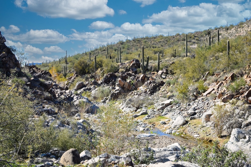
The recreation area derives its name from the distinctive flat-topped mesa formations that punctuate the landscape, geological features that tell the story of millions of years of erosion and uplift. These mesas rise above a complex network of washes, arroyos, and rolling desert hills covered with classic Sonoran Desert vegetation, creating a visually striking backdrop for a wide range of recreational pursuits. The western portion of the recreation area encompasses segments of the Agua Fria River, which flows seasonally through a scenic canyon, providing vital riparian habitat and opportunities for water-based recreation during periods of adequate flow.
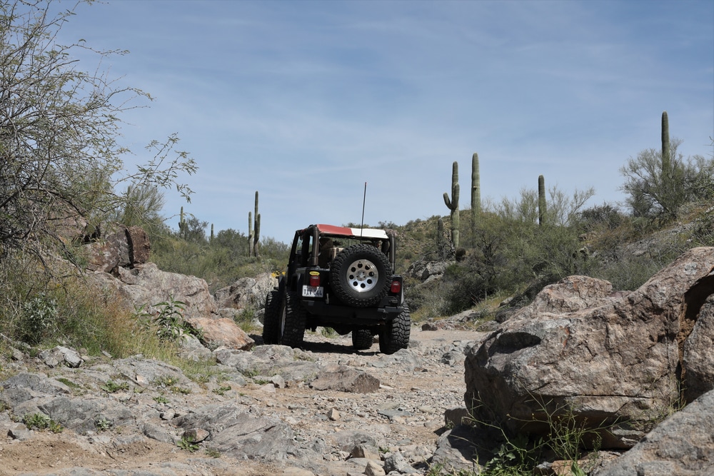
Table Mesa is a haven for off-roading enthusiasts, with miles of trails suitable for 4×4 vehicles, dirt bikes, and ATVs. The trails range from easy to highly challenging, featuring rocky climbs, washes, and steep descents. Popular trails include:
Be sure to have a high-clearance, 4WD vehicle and check weather conditions before heading out.
The Table Mesa Recreation Area is a popular spot for recreational shooting. There are designated shooting areas where visitors can safely practice target shooting. Always follow firearm safety guidelines and clean up after yourself to help maintain the area’s natural beauty.

While off-roading is the main attraction, the area also offers hiking opportunities for those looking to explore on foot. Trails and washes lead through the Sonoran Desert landscape, providing stunning views of cacti, rugged hills, and distant mountain ranges. Hiking is best during the cooler months, as temperatures can rise significantly in summer.

The recreation area offers dispersed camping, allowing visitors to set up camp in remote areas surrounded by desert solitude. There are no developed campgrounds, so you’ll need to bring all necessary supplies, including water and firewood. Camping here offers a great opportunity for stargazing, as the area has limited light pollution.

Table Mesa is a well-known destination for rock crawling, with trails like Predator and Annihilator offering extreme challenges for experienced drivers. These trails feature large boulders, ledges, and tight squeezes, making them perfect for those seeking a technical off-roading experience.

The dramatic desert scenery, with its towering saguaro cacti, rugged rock formations, and expansive vistas, provides excellent opportunities for photography. Sunrise and sunset are particularly beautiful times to capture the unique colors of the desert.

The Sonoran Desert is home to diverse wildlife, and Table Mesa is no exception. Keep an eye out for desert creatures like coyotes, jackrabbits, quail, and reptiles. Birdwatchers may spot hawks, owls, and other birds of prey soaring overhead.
With its remote location and minimal light pollution, Table Mesa Recreation Area is a fantastic spot for stargazing. Bring a telescope or simply lay out a blanket to enjoy the clear desert skies filled with stars, planets, and the Milky Way.

While primarily known for off-roading, some trails in the area are suitable for mountain biking. The rocky and sandy terrain can be challenging, but it offers a rewarding experience for skilled riders. Be sure to bring plenty of water and be mindful of other users on the trails.
| Category | Details |
|---|---|
| Location | North of Phoenix, Arizona, USA, near Interstate 17 |
| Managed By | U.S. Bureau of Land Management (BLM) |
| Size | Part of the broader Sonoran Desert public lands |
| Main Attractions | Off-highway vehicle (OHV) trails, shooting areas, hiking, and desert views |
| Terrain | Rugged desert terrain with rocky hills, washes, and mesas |
| Ecosystem | Sonoran Desert with saguaro cacti, palo verde trees, and desert wildlife |
| Activities | OHV riding, target shooting, hiking, camping, and wildlife viewing |
| Visitor Requirements | No entrance fee; permits may be required for specific activities (e.g., group events) |
| Nearby Landmarks | Lake Pleasant Regional Park, Black Canyon Trail |
| Accessibility | Accessible by dirt roads; high-clearance or 4WD vehicles recommended for certain areas |
| Safety Considerations | – Be cautious of shooting areas and stay in designated zones.<br>- Bring plenty of water, as the area is remote and lacks facilities. |
| Climate | Hot summers with mild winters; limited shade |
| Fun Fact | The area is a popular destination for off-road enthusiasts due to its challenging trails. |
Table Mesa Recreation Area is strategically positioned at the northern edge of the Phoenix metropolitan area, making it one of the most accessible BLM recreation sites in central Arizona. The recreation area lies within Yavapai County, though its southern boundary nearly touches Maricopa County.
Primary access is via Interstate 17, which forms much of the eastern boundary of the recreation area:
Secondary access points include:
The strategic location approximately 35 miles north of central Phoenix places Table Mesa within an hour’s drive for most metropolitan residents, making it an ideal destination for day trips and weekend excursions. This accessibility has contributed significantly to its popularity among diverse user groups.
The topography of Table Mesa Recreation Area is characterized by remarkable diversity, with elevations ranging from approximately 1,600 feet along the Agua Fria River to over 3,000 feet at the highest mesas. This varied terrain creates distinct recreational zones and ecological niches:
The namesake features of the recreation area, these flat-topped prominences are composed of resistant volcanic rock layers that have withstood erosion while surrounding softer materials have been worn away. The mesas provide distinctive landmarks and create challenging terrain for OHV enthusiasts and hikers alike.
Between the mesas, the landscape consists of gently rolling terrain dissected by numerous shallow washes and drainages. These areas support classic Sonoran Desert vegetation and provide relatively accessible cross-country travel for various recreational uses.
The western portion of the recreation area encompasses segments of the Agua Fria River corridor, where the waterway has carved a scenic canyon through volcanic and sedimentary rock layers. This riparian zone creates a striking contrast to the surrounding desert uplands.
Throughout the recreation area, a complex network of seasonal washes channels rainfall toward the Agua Fria River. These sandy drainages range from narrow, boulder-strewn channels to broad, sandy washes that serve as natural travel corridors for both wildlife and human visitors.
The overall topography creates a visually striking landscape of contrasts – from distant panoramic views atop the mesas to intimate canyon settings along the river corridor. This diversity contributes significantly to the recreational appeal of the area, providing suitable terrain for varied activities and skill levels.
Table Mesa Recreation Area showcases fascinating geological processes that have shaped central Arizona’s landscape over millions of years. The dominant geological features include:
Much of the area’s bedrock consists of basaltic lava flows and related volcanic materials dating from the mid-Tertiary period (approximately 15-25 million years ago). These volcanic layers are visible in the cliff faces of the mesas and in exposed rock outcroppings throughout the area.
Between and beneath the volcanic layers, segments of older sedimentary rocks are occasionally visible, particularly in areas where erosion has cut deeply into the landscape. These deposits tell the story of ancient river systems and lake beds that preceded the volcanic activity.
Many rock surfaces display the characteristic dark coating known as desert varnish – a thin layer of clay minerals and manganese and iron oxides deposited by microorganisms over thousands of years. This natural patina gives many rock formations a distinctive blackened appearance that contrasts with freshly broken surfaces.
Throughout the recreation area, water has sculpted the landscape into fascinating forms, from deeply incised canyons to smooth, water-polished boulders in wash bottoms. Flash flooding continues to shape the terrain with each major rainfall event.
The area has a history of small-scale mining activity, particularly for gold and copper. While no active mines operate within the recreation area today, observant visitors may notice evidence of historical prospecting and extraction activities.
The geological diversity creates not only visual interest but also the varied terrain that supports the area’s recreational opportunities, particularly for OHV enthusiasts who seek out challenging rock features and elevation changes.
Table Mesa experiences the arid climate typical of the upper Sonoran Desert, characterized by:
Summer daytime highs frequently exceed 100°F (38°C) from June through September, with occasional peaks reaching 110-115°F (43-46°C). Winter brings much milder conditions, with daytime temperatures typically ranging from 60-70°F (15-21°C) and overnight lows occasionally dropping below freezing during December-February.
Annual rainfall averages approximately 10-12 inches (25-30 cm), with distinct wet seasons during the winter months (December-March) and the summer monsoon (July-September). Spring and fall typically represent the driest periods. Rainfall events tend to be intense and localized, creating potential for flash flooding in washes and low-lying areas.
Each season offers distinct recreational experiences:
The climate significantly influences visitor patterns, with peak visitation occurring during the milder months (October-April) and noticeably reduced activity during summer heat, except for early mornings and evenings. Weather awareness is essential for visitor safety, particularly regarding flash flood potential during the monsoon season and extreme heat dangers during summer.
Table Mesa Recreation Area sits within the Arizona Upland subdivision of the Sonoran Desert, considered the lushest and most diverse of North America’s desert regions. This ecosystem is characterized by:
The interaction between the area’s varied topography and the Sonoran Desert climate creates a mosaic of habitats that support remarkable biodiversity within a relatively small geographic area.
The plant communities of Table Mesa showcase the remarkable adaptations that allow vegetation to thrive in this challenging environment:
Saguaro Cactus (Carnegiea gigantea): These iconic columnar cacti are abundant throughout the recreation area, with some specimens estimated to be 150-200 years old. Their height and distinctive form create the classic Sonoran Desert landscape recognized worldwide.
Paloverde Trees (Parkinsonia species): These green-barked trees dominate the upper desert landscape, providing essential shade and habitat while adding vibrant yellow blooms during spring flowering.
Ironwood (Olneya tesota): These slow-growing desert trees with their extremely dense wood represent an important habitat resource, supporting numerous other species and providing distinctive lavender blooms in late spring.
Cholla and Prickly Pear Cacti (Cylindropuntia and Opuntia species): Several varieties of these distinctive cacti create visually striking arrangements throughout the landscape.
Creosote Bush (Larrea tridentata): This highly drought-tolerant shrub dominates many of the flatter areas, releasing its characteristic aromatic scent after rainfall.
Jojoba (Simmondsia chinensis): This important native shrub produces valuable oil-rich seeds used by wildlife and in commercial products.
Ocotillo (Fouquieria splendens): These unusual plants with their tall, whip-like stems leafed out after rainfall and topped with bright red flower clusters in spring create distinctive vertical elements in the landscape.
Cottonwood (Populus fremontii) and Willow (Salix species): These water-loving trees establish along the Agua Fria River in areas of reliable subsurface moisture.
Mesquite (Prosopis species): These deep-rooted trees form dense stands along the river terraces.
Desert Willow (Chilopsis linearis): Though not a true willow, these distinctive trees with tubular flowers thrive in washes with seasonal water flow.
Catclaw Acacia (Senegalia greggii): These thorny shrubs form dense thickets along water courses, providing important wildlife habitat.
Following adequate winter rainfall, the spring months (February-April) can bring spectacular wildflower displays, including:
Desert lupine, poppies, owl clover, globemallow, brittlebush, and numerous other colorful species that transform the landscape briefly before the summer heat arrives.
The plant communities provide not only visual appeal but also critical habitat resources, with many species serving as “nurse plants” that create microhabitats facilitating the establishment of other vegetation—a key ecological relationship in desert environments.
The diverse habitats within Table Mesa support an impressive array of wildlife, though many species remain elusive due to their nocturnal habits or wariness around human activity:
Mule Deer: Small groups of these adaptable ungulates can occasionally be spotted in early morning or evening, particularly near the riparian corridor.
Javelina (Collared Peccary): These pig-like mammals travel in family groups throughout the area, often leaving distinctive rooting evidence where they’ve foraged for roots and tubers.
Coyotes: Common throughout the recreation area, these adaptable predators are more often heard than seen.
Bobcats: These elusive felines hunt throughout the area but are rarely encountered by visitors.
Desert Cottontails and Jackrabbits: These lagomorphs are among the most commonly observed mammals, particularly around dawn and dusk.
Ground Squirrels and Pocket Mice: Several species of these small mammals are active during daylight hours, particularly in cooler seasons.
Bats: Multiple bat species feed on insects throughout the area, with some species roosting in rock crevices within the recreation area.
Western Diamondback Rattlesnake: This venomous species requires respect and caution but is typically non-aggressive unless threatened.
Gopher Snake: This large, beneficial, non-venomous snake is sometimes mistaken for a rattlesnake due to its similar coloration and defensive behavior.
Desert Spiny Lizard: These colorful lizards are frequently seen doing “push-ups” on rocks, a territorial display behavior.
Common Chuckwalla: These large-bodied lizards inhabit rocky areas, retreating into crevices when threatened and inflating their bodies to wedge themselves securely.
Desert Tortoise: While increasingly rare, these protected reptiles occasionally make appearances, particularly after rainfall events.
Raptors: Several species hunt across the recreation area, including red-tailed hawks, Cooper’s hawks, American kestrels, and occasionally golden eagles.
Gambel’s Quail: These charismatic birds with their distinctive topknots are often seen in coveys moving through desert scrub.
Greater Roadrunner: These fast-running birds are ground-dwelling predators that occasionally cross roads and trails.
Cactus Wren: Arizona’s state bird nests in chollas and other protective vegetation throughout the area.
Black-throated Sparrow: This desert specialist features a distinctive black throat and white eye stripe.
Gila Woodpecker: These woodpeckers excavate nest cavities in saguaro cacti, creating homes that are later used by many other species.
Migratory Songbirds: During spring and fall migrations, numerous species pass through the area, temporarily increasing avian diversity.
The Agua Fria River corridor serves as a particularly important wildlife habitat, providing water and denser vegetation that attracts a greater diversity and abundance of species than the surrounding uplands. Seasonal variation in wildlife activity is significant, with many species adopting crepuscular (dawn and dusk) or nocturnal behavior during summer months to avoid extreme temperatures.
Table Mesa Recreation Area offers a remarkable diversity of recreational activities, accommodating a wide range of interests and skill levels. The area’s popularity stems in part from this versatility, allowing different user groups to enjoy the same public land resource in complementary ways.
OHV recreation represents the most popular activity at Table Mesa, with users ranging from casual day-trippers in family SUVs to dedicated rock-crawling enthusiasts in heavily modified vehicles:
The area features approximately 200 miles of designated routes, organized into a network that accommodates various vehicle types and driver skill levels:
Easy Routes: Well-maintained dirt roads suitable for stock 4×4 vehicles and ATVs, providing scenic access to much of the recreation area
Moderate Routes: Trails featuring rougher terrain, occasional rock obstacles, and moderate elevation changes
Difficult/Technical Routes: Challenging paths with significant rock obstacles, steep climbs, and technical features that require specialized vehicles and experienced drivers
Since 2010, the BLM has implemented a comprehensive route designation system with specific trails open to different vehicle types:
All Vehicle Routes: Open to full-size 4x4s, SUVs, and trucks as well as smaller OHVs
ATV/UTV Routes: Designed for quads, side-by-sides, and other smaller vehicles
Motorcycle Trails: Narrower single-track paths specifically for dirt bikes
Closed Routes: Areas where motorized travel is prohibited to protect resources or address safety concerns
Several zones within the recreation area are known for extreme rock crawling opportunities, with names like “Terminator,” “Predator,” and “The Notch” drawing enthusiasts seeking technical challenges for highly modified vehicles.
Several developed parking and staging areas provide convenient access points:
Main Table Mesa Staging Area: Located approximately 1 mile west of I-17, offering a large parking area, information kiosks, and direct trail access
Boulders Staging Area: A popular gathering point for rock crawling enthusiasts, located in the central portion of the recreation area
Emery Henderson Trailhead: Offers developed parking and access to the southern trail system
The variety of OHV opportunities makes Table Mesa suitable for everything from family outings to organized club events, with many visitors progressing to increasingly challenging routes as their skills and equipment evolve.
While not as developed for non-motorized recreation as some other areas, Table Mesa offers rewarding hiking and trail running experiences:
Though few formally designated hiking trails exist, numerous user-created paths lead to scenic viewpoints and interesting geological features. Popular hiking destinations include:
Mesa Tops: Several accessible mesas offer panoramic views of the surrounding desert and distant mountain ranges
Agua Fria River: Trails follow portions of the river corridor, providing access to riparian environments and seasonal pools
Boulder Fields: Unique geological formations create interesting exploration opportunities
The southern portion of the recreation area provides access points to segments of the Black Canyon Trail, a premier long-distance trail that extends over 80 miles from Highway 69 near Prescott to the Carefree Highway north of Phoenix.
Hikers seeking solitude typically visit on weekdays or focus on areas less frequented by motorized users, particularly some of the more remote mesa tops and ridgelines.
Mountain biking opportunities at Table Mesa range from casual rides on dirt roads to more technical routes shared with OHV users:
Doubletrack Routes: Many of the main dirt roads provide enjoyable riding with moderate technical challenges
Technical Singletrack: Some motorcycle trails are suitable for experienced mountain bikers seeking more challenging terrain
Black Canyon Trail Access: As with hiking, the southern area provides connections to this premier mountain biking destination
Mountain biking at Table Mesa tends to attract experienced riders comfortable sharing trails with motorized users and seeking more technical challenges than those found in dedicated mountain biking areas closer to Phoenix.
Horseback riding is permitted throughout Table Mesa Recreation Area, though it represents a relatively small percentage of overall visitation:
Most equestrian use focuses on:
Table Mesa has historically been a popular location for recreational target shooting, though management of this activity has evolved to address safety concerns and resource impacts:
Following safety incidents and resource damage concerns, the BLM has worked to concentrate shooting activities in designated areas equipped with:
During periods of high fire danger, typically in late spring and summer, shooting restrictions may be implemented to reduce wildfire risk.
Responsible target shooting remains a legitimate recreational use of the area, though the BLM continues to manage this activity to ensure compatibility with other recreation types and resource protection.
Dispersed camping is permitted throughout much of Table Mesa Recreation Area, providing opportunities for overnight stays in a desert setting:
Most camping at Table Mesa is vehicle-based, with visitors using RVs, trailers, truck campers, or car camping setups rather than backpacking style tent camping.
Despite the popularity of motorized recreation, Table Mesa offers rewarding opportunities for wildlife viewing, plant observation, and landscape photography:
Best opportunities exist:
Visitors primarily interested in nature observation often choose weekday visits and areas farther from the main OHV routes to maximize their experiences.
The extreme temperature variations of central Arizona’s desert climate create distinct seasonal visitation patterns and considerations for Table Mesa Recreation Area:
Fall represents one of the most favorable seasons for visiting Table Mesa:
Fall visitors benefit from nearly perfect weather conditions but should expect increased visitation, particularly on weekends. Those seeking solitude might consider weekday visits during this prime season.
Winter brings mild days and cool nights to Table Mesa:
Winter visitors should prepare for potentially cold overnight temperatures if camping, with layers for morning chill that can be removed as the day warms. The pleasant daytime conditions make this season ideal for more physically demanding activities like hiking and mountain biking.
Spring offers another prime visitation period:
Spring visitors experience the desert at its most vibrant but should plan for increasing heat as the season progresses. Early spring visits offer the best combination of comfortable temperatures and active desert ecology.
Summer presents challenging conditions at Table Mesa:
Summer visitors must take serious heat precautions, including:
Based on these seasonal patterns, the most favorable times to visit Table Mesa Recreation Area are:
These periods offer the best combination of comfortable temperatures, stable weather conditions, and reasonable visitation levels. Weekend visitors during these optimal times should expect to share the area with numerous other recreationists, particularly OHV enthusiasts, while weekday visitors will find significantly reduced crowds.
Table Mesa Recreation Area is readily accessible from Interstate 17, the main north-south corridor between Phoenix and Flagstaff:
GPS Coordinates for Main Staging Area: 33°53’45″N, 112°8’45″W
Road conditions within the recreation area vary considerably:
As a primarily undeveloped recreation area, Table Mesa offers limited facilities:
The primitive nature of facilities requires visitors to be self-sufficient and well-prepared for their activities, particularly regarding water, food, first aid supplies, and vehicle recovery equipment if engaging in OHV recreation.
Visitors to Table Mesa must adhere to BLM regulations designed to protect resources and ensure visitor safety:
These regulations are enforced through periodic patrols by BLM rangers, with citations and fines possible for violations. Temporary restrictions (particularly regarding fire and shooting) may be implemented based on conditions, and visitors should check current status before their trip.
The remote location, extreme climate, and diverse recreational uses at Table Mesa create several safety considerations visitors should address:
Being prepared for these potential hazards ensures a safer and more enjoyable experience at Table Mesa. Self-sufficiency and conservative decision-making are essential given the environmental challenges and limited emergency services.
The lands encompassing Table Mesa Recreation Area have been home to indigenous peoples for thousands of years, with archaeological evidence suggesting human presence dating back at least 10,000 years. This region falls within the traditional territories of several Native American groups:
The Yavapai people traditionally utilized these lands for seasonal hunting and gathering, with evidence of temporary camps and resource procurement sites throughout the area. The riparian corridor of the Agua Fria River was particularly important for both resources and transportation.
Hohokam cultural influences extend into this region, particularly evident in pottery shards and agricultural features found near water sources. The Hohokam created extensive irrigation systems in central Arizona between approximately 300-1450 CE.
We use cookies to improve your experience on our site. By using our site, you consent to cookies.
Manage your cookie preferences below:
Essential cookies enable basic functions and are necessary for the proper function of the website.