The Harquahala Mountains Wilderness stands as one of Arizona’s most impressive yet under-appreciated natural treasures. Spanning 22,880 acres across Maricopa and La Paz counties, approximately 80 miles northwest of Phoenix, this federally protected wilderness area encompasses part of one of western Arizona’s largest desert mountain ranges. Designated by the Arizona Desert Wilderness Act of 1990, the Harquahala Mountains Wilderness preserves a remarkable landscape characterized by dramatic elevation changes, diverse ecosystems, and significant cultural history.
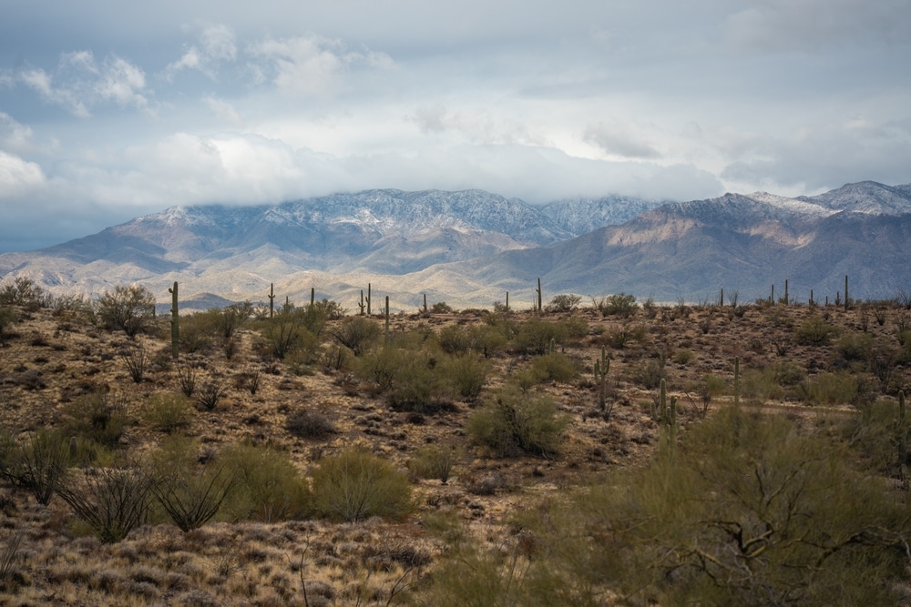
The name “Harquahala” originates from the Yavapai language term “ʼHakhe:la,” meaning “running water high up,” a reference to the numerous perennial springs and seeps that dot this otherwise arid landscape. This elevated desert range rises dramatically from the surrounding flatlands, with elevations ranging from 2,100 feet at the base to over 5,691 feet at Harquahala Peak, the highest point in southwestern Arizona. From these lofty heights, visitors are rewarded with breathtaking panoramic views that can extend up to 100 miles on clear days, showcasing the stunning beauty of Arizona’s desert landscapes.
What truly sets the Harquahala Mountains Wilderness apart from many Sonoran Desert mountain ranges is its unique interior canyon system, which creates a screened environment supporting exceptional natural diversity. Within this protected area, visitors can discover relict “islands” of interior chaparral, desert grasslands, and populations of rare cacti. The wilderness also serves as vital habitat for numerous wildlife species, including one of the few increasing herds of desert bighorn sheep, the largest mule deer population in western Arizona, mountain lions, desert tortoises, and diverse bird species.
Beyond its natural wonders, the Harquahala Mountains boast a fascinating human history. The summit of Harquahala Peak was once home to a Smithsonian Astrophysical Observatory, built in 1920 to study solar activity. The remnants of this historic scientific outpost, along with evidence of early mining operations and Native American presence, add layers of cultural significance to the wilderness experience. Today, the Harquahala Mountains Wilderness offers visitors opportunities for hiking, backpacking, wildlife observation, photography, and the increasingly rare chance to experience profound desert solitude in an increasingly connected world.

The Harquahala Peak Trail is one of the main attractions of this wilderness and provides a challenging yet rewarding experience for hikers. Spanning approximately 11 miles round trip, the trail climbs over 3,300 feet in elevation, making it a strenuous endeavor. Along the way, hikers are treated to breathtaking views of the surrounding Sonoran Desert, including distant ranges such as the Kofa and Eagletail Mountains. The trail takes visitors through diverse desert vegetation, including saguaro cacti, palo verde trees, and ocotillos, before reaching the summit.

The Smithsonian Solar Observatory, located at the summit of Harquahala Peak, is a key historical feature of the wilderness. Built in the early 20th century, this observatory was one of the first facilities dedicated to studying solar activity and its impact on the Earth. Scientists endured harsh conditions at the remote mountaintop site, transporting equipment and supplies by mule and performing their research amid extreme temperatures and isolation. Today, the remains of the observatory serve as a fascinating reminder of the dedication and ingenuity of early researchers.

The Harquahala Mountains are home to a rich variety of desert flora and fauna. Visitors may encounter desert bighorn sheep navigating the rocky cliffs or spot golden eagles soaring overhead. Other wildlife includes coyotes, mule deer, and smaller creatures such as lizards and jackrabbits. Spring is an especially beautiful time to visit, as wildflowers bloom across the desert floor, adding vibrant splashes of color to the rugged landscape.
The vegetation is typical of the Sonoran Desert, with towering saguaro cacti, cholla, and creosote bushes dominating the terrain. The higher elevations of the wilderness feature a slightly cooler climate and different plant communities, providing a striking contrast to the arid desert below.
While there are no developed campgrounds within the Harquahala Mountains Wilderness, dispersed camping is allowed. The remote location and lack of light pollution make the area an excellent spot for stargazing. On clear nights, the sky comes alive with countless stars, constellations, and even the Milky Way. Camping here provides a chance to fully immerse yourself in the tranquility of the desert, surrounded by sweeping views and the sounds of nature.
| Category | Details |
|---|---|
| Location | La Paz and Maricopa Counties, western Arizona, USA |
| Established | 1990 |
| Managed by | Bureau of Land Management (BLM) |
| Area | Approximately 22,880 acres (9,261 hectares) |
| Primary Features | Rugged desert mountain range with Harquahala Peak, the highest point in southwestern Arizona at 5,681 feet (1,731 meters) |
| Nearest Cities | Wenden, Salome, and Aguila, Arizona |
| Activities | Hiking, wildlife viewing, camping, photography, and historical exploration |
| Topography | Steep mountain ridges, rocky outcrops, desert valleys, and scenic vistas |
| Historical Significance | Harquahala Peak was the site of a Smithsonian Astrophysical Observatory (1920s) used to study solar activity |
| Wildlife | Desert bighorn sheep, mule deer, coyotes, foxes, lizards, snakes, and bird species like golden eagles and hawks |
| Vegetation | Saguaro cacti, ocotillo, palo verde trees, creosote bush, and desert wildflowers |
| Climate | Arid desert climate with hot summers and mild winters |
| Access Points | Dirt roads provide access to the wilderness boundary; high-clearance or 4WD vehicles are recommended |
| Restrictions | No motorized vehicles or mechanical equipment within the wilderness area |
| Significance | Protects a pristine desert mountain ecosystem and offers opportunities for solitude and backcountry exploration |
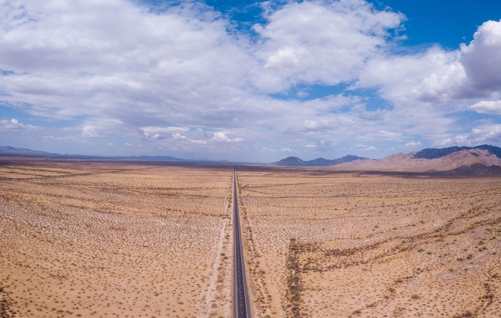
The Harquahala Mountains form a prominent range in western Arizona, oriented northeast to southwest and measuring approximately 20 miles (32 km) long by 12 miles (20 km) at its widest point. The wilderness area encompasses the northeastern portion of this range, including several significant peaks and canyons. The range is located southwest of the small towns of Aguila and Wenden, with the McMullen Valley to the north and the La Posa Plain to the south.
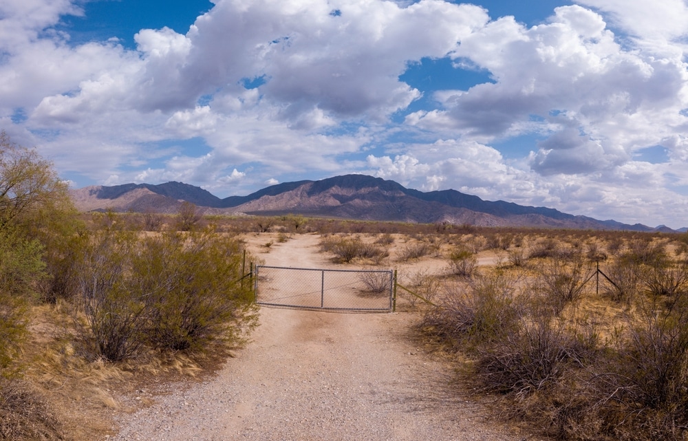
Access to the Harquahala Mountains Wilderness requires planning and appropriate vehicles. Primary access routes include:
From the North: Paved State Route 60 provides access to several jeep trails that extend to the wilderness area’s northern boundary. These primitive roads are often rough and may require high-clearance vehicles.
From the South: The paved Eagle Eye Road, which runs south from Aguila toward Interstate 10, provides access to numerous jeep trails along the wilderness area’s southern side. These routes vary in condition and difficulty.
Harquahala Mountain Backcountry Byway: This challenging 10.5-mile road approaches Harquahala Peak from the south and requires high-clearance, four-wheel-drive vehicles. The road is steep, winding, and narrow, particularly in the final three-quarters of a mile, which climbs 1,400 feet to the summit. While this route reaches Harquahala Peak (which sits just outside the wilderness boundary), it provides access to hiking trails that enter the wilderness area.
Visitors should note that many lands surrounding the wilderness are privately owned or state trust lands. Always respect property boundaries and obtain appropriate permits when necessary. Additionally, all motorized and mechanized travel is prohibited within the designated wilderness boundary, in accordance with the Wilderness Act of 1964. Visitors must proceed on foot or horseback once they enter the wilderness area.
Rising to 5,691 feet, Harquahala Peak stands as the highest point in southwestern Arizona. Though the peak itself lies just outside the wilderness boundary, it offers unparalleled views of the surrounding wilderness and beyond. On clear days, visibility can extend up to 100 miles, with spectacular 360-degree panoramas of surrounding desert and distant mountain ranges. The peak is accessible via the challenging Harquahala Mountain Backcountry Byway or by hiking the 5.4-mile Harquahala Peak Trail from the north.
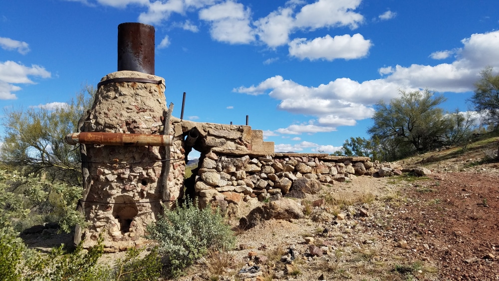
One of the most fascinating historical features of the area is the abandoned Smithsonian Astrophysical Observatory atop Harquahala Peak. Built in 1920, the observatory was operated by scientists who lived and worked at this remote location from 1920 to 1925, measuring and recording solar activity. The site was chosen for its remoteness from pollution and the region’s high percentage of cloudless days, making it ideal for solar observation. Today, visitors can explore the ruins of this historic scientific outpost, which is listed on the National Register of Historic Places. Interpretive panels at the site provide information about the observatory’s history and the challenging lives of the scientists who staffed it.
This nine-mile-long canyon stretches across the northeastern portion of the wilderness area and represents one of the most secluded and ecologically significant features of the Harquahala Mountains. Brown’s Canyon is rarely visited, providing exceptional opportunities for solitude. It also serves as important habitat for the endangered desert tortoise, along with numerous other species. The canyon’s sheltered environment creates a unique microclimate supporting diverse plant and animal communities.
One of the most dramatic topographical features in the wilderness, Sunset Canyon drops approximately 1,600 feet from the steep eastern rim of the mountains to the desert floor below. This impressive canyon showcases the range’s vertical relief and provides challenging terrain for experienced hikers. The canyon walls display the area’s complex geology, with exposed rock formations and colorful mineral deposits.
Perhaps the most ecologically significant features of the Harquahala Mountains Wilderness are the relict “islands” of interior chaparral vegetation. These isolated plant communities, typically found at higher elevations in more northern regions, have persisted here due to the unique environmental conditions created by elevation and aspect. These chaparral communities contain plant species otherwise rare in the Sonoran Desert and serve as important habitat for specialized wildlife.
The Harquahala Mountains were formed through a complex series of geological processes including volcanic activity, tectonic uplift, and extensive erosion. The range consists primarily of metamorphic and igneous rock, with some areas showing evidence of ancient seabed deposits uplifted over millions of years. The mountains’ rugged topography includes steep ridgelines, deep canyons, dramatic peaks, and gentler bajadas (alluvial fans) at lower elevations. Geologists have identified various mineral deposits throughout the range, which explains the area’s history of mining activity.
The Harquahala Mountains Wilderness experiences a typical Sonoran Desert climate, characterized by extreme temperature variations and limited precipitation. Summer temperatures regularly exceed 100°F (38°C), with July averages reaching 90°F (32°C). Winter brings more moderate conditions, with January temperatures averaging around 48°F (9°C). At higher elevations, temperatures are generally cooler, and the peaks occasionally receive snow during winter months.
Annual precipitation averages just 6 inches, with rainfall patterns divided between winter storms (December through March) and the summer monsoon season (July through September). These seasonal rains support the wilderness area’s diverse plant communities and replenish the springs and seeps that give the range its name. Visitors should be aware that summer thunderstorms can be violent and dangerous, particularly at higher elevations, while flash flooding can occur in canyons and washes during heavy rain events.
The Harquahala Mountains Wilderness supports an exceptional diversity of plant life, with communities varying dramatically based on elevation, aspect, and hydrological conditions. This diversity is greater than in many surrounding desert ranges due to the presence of perennial springs and the range’s significant elevation gradient.
Lower elevations feature typical Sonoran Desert vegetation, including:
At middle elevations, particularly in sheltered canyons with greater moisture, visitors may encounter:
Higher elevations and north-facing slopes support the unusual interior chaparral communities, including:
The wilderness also harbors populations of rare cacti and other plant species of conservation concern. After wet winters, spring wildflower displays can be spectacular, typically peaking between late February and early April depending on elevation and rainfall patterns.
The diverse habitats of the Harquahala Mountains Wilderness support an equally impressive variety of wildlife. The wilderness area is particularly notable for supporting:
Desert Bighorn Sheep (Ovis canadensis nelsoni): One of the few increasing herds in the region, these magnificent mammals can sometimes be observed on steep, rocky slopes.
Mule Deer (Odocoileus hemionus): The largest population of mule deer in western Arizona inhabits the Harquahala Mountains, particularly in areas with access to water and vegetation.
Desert Tortoise (Gopherus agassizii): This threatened species finds sanctuary in several areas of the wilderness, particularly in Brown’s Canyon.
Mountain Lion (Puma concolor): These elusive predators roam throughout the wilderness, though sightings are rare due to their secretive nature.
Raptors: A sizable raptor population includes golden eagles, red-tailed hawks, prairie falcons, and great horned owls.
Reptiles: The Gila monster, western diamondback rattlesnake, and numerous lizard species inhabit the lower elevations.
Small Mammals: Jackrabbits, desert cottontails, ground squirrels, and various rodent species are common throughout the wilderness.
Visitors should exercise caution with wildlife, keeping a respectful distance from all animals and being particularly aware of venomous species like rattlesnakes, which are active primarily during warmer months.
The Harquahala Mountains Wilderness offers exceptional opportunities for hiking and backpacking, though visitors should note that most routes are primitive and unmarked, requiring good navigation skills and physical conditioning. The most established trail in the area is:
Harquahala Peak Trail: This 5.4-mile (one-way) trail leads from the northern base of the mountains to the summit of Harquahala Peak. Originally established as a pack trail for the Smithsonian Observatory, the path is marked by rock cairns and offers increasingly dramatic views as it climbs. While strenuous, the trail has a reasonable grade since it was designed for mule travel. The trailhead is accessible via jeep trails extending south from Highway 60.
Beyond this established route, hiking in the wilderness typically involves cross-country travel following ridgelines, canyons, or game trails. Some notable destinations include:
Brown’s Canyon: This secluded nine-mile canyon offers pristine wilderness experiences and opportunities to observe desert tortoise and other wildlife.
Sunset Canyon: More challenging terrain with dramatic drops and exceptional views.
Interior Ridge Systems: Following the high ridgelines provides spectacular vistas and access to the chaparral ecosystems.
Backpacking opportunities abound, though water scarcity is a significant consideration. Most overnight trips require carrying all necessary water, as springs and seeps are unreliable and may be dry for extended periods. The best seasons for extended hiking and backpacking are fall, winter, and early spring, when temperatures are more moderate.
The diverse habitats and wildlife populations of the Harquahala Mountains Wilderness make it an excellent destination for wildlife observation and photography. Early morning and late afternoon typically offer the best opportunities for wildlife sightings and optimal lighting conditions for photography. Bringing binoculars is highly recommended, as many animals (particularly bighorn sheep and raptors) may be observed at a distance.
The varied topography, plant communities, and dramatic light of the Sonoran Desert also provide exceptional opportunities for landscape photography, particularly during the golden hours around sunrise and sunset. Spring wildflower displays can be spectacular in years with adequate winter rainfall, typically peaking between late February and early April.
Equestrian use is permitted throughout the wilderness area, with the Harquahala Peak Trail being particularly suitable for horses given its origin as a pack trail. Riders must bring all necessary water for their animals, as natural water sources are scarce and unreliable. The rugged terrain limits extensive riding in many parts of the wilderness, but the experience of exploring this remote landscape on horseback connects visitors to the area’s historical patterns of travel and exploration.
Beyond natural history, the Harquahala Mountains offer opportunities to connect with human history spanning centuries. The summit area near the Smithsonian Observatory contains interpretive displays about the scientific work conducted there and the challenges of daily life at this remote outpost. Throughout the range, visitors may encounter evidence of historical mining operations, including stone house remains and mechanical debris (though visitors should not disturb these historical artifacts).
The Harquahala Mountains Wilderness is best visited from October through April, when temperatures are most moderate. Winter (December through February) brings cooler conditions, with occasional snow at higher elevations, but generally comfortable daytime temperatures for hiking. Spring (March through May) often features wildflower displays and mild temperatures, making it perhaps the most popular season. Summer months (June through September) bring extreme heat, with temperatures regularly exceeding 100°F (38°C), making extensive hiking dangerous without exceptional preparation and experience.
Visitors to the Harquahala Mountains Wilderness should be prepared for a remote desert environment with minimal facilities and emergency services:
Water: There are no reliable water sources within the wilderness. Visitors must carry all necessary water, with a recommended minimum of one gallon per person per day in cool weather and significantly more during warmer periods.
Navigation: Most of the wilderness lacks established trails. Visitors should carry detailed topographic maps and a compass, and know how to use them. GPS devices are helpful but should not be solely relied upon.
Heat Exposure: Heat-related illnesses are a serious risk, particularly from May through September. Hike during cooler morning hours, carry abundant water, wear appropriate clothing, and know the signs of heat exhaustion and heat stroke.
Wildlife: Venomous creatures including rattlesnakes and scorpions inhabit the wilderness. Always check before placing hands or feet, especially when climbing or around rock piles. Avoid harassment of wildlife and maintain a respectful distance.
Flash Floods: During the summer monsoon season, sudden thunderstorms can cause dangerous flash flooding in canyons and washes. Avoid camping in drainage areas and be aware of weather forecasts.
Communications: Cell phone coverage is extremely limited or non-existent in most of the wilderness area. Consider carrying a satellite communication device for emergencies.
Old Mines: Remnants of mining operations pose significant hazards. Avoid entering old mine shafts or structures, which may be unstable.
No specific permits are required for day use or overnight camping within the Harquahala Mountains Wilderness. However, visitors should be aware of these key regulations:
The remote and fragile nature of the Harquahala Mountains Wilderness makes adherence to Leave No Trace principles particularly important:
Plan Ahead and Prepare: Know the regulations, prepare for extreme weather, schedule your trip to avoid times of high use, and use a map and compass to eliminate the need for rock cairns or flagging.
Travel and Camp on Durable Surfaces: In this desert environment, durable surfaces include established campsites, rock, gravel, dry grasses, or snow. Good campsites are found, not made. Altering a site is not necessary.
Dispose of Waste Properly: Pack out all trash, leftover food, and litter. Deposit human waste in catholes dug 6-8 inches deep at least 200 feet from water, camp, and trails. Cover and disguise the cathole when finished. Pack out toilet paper and hygiene products.
Leave What You Find: Preserve the past by examining but not touching cultural or historic structures and artifacts. Leave rocks, plants, and other natural objects as you find them.
Minimize Campfire Impacts: Campfires can cause lasting impacts to the backcountry. Use a lightweight stove for cooking and enjoy a candle lantern for light. Where fires are permitted, use established fire rings, fire pans, or fire blankets.
Respect Wildlife: Observe wildlife from a distance. Do not follow or approach them. Never feed animals. Feeding wildlife damages their health, alters natural behaviors, and exposes them to predators and other dangers.
Be Considerate of Other Visitors: Respect other visitors and protect the quality of their experience. Be courteous. Yield to others on the trail. Step to the downhill side of the trail when encountering pack stock. Take breaks and camp away from trails and other visitors.
The Harquahala Mountains Wilderness is managed by the Bureau of Land Management (BLM) as part of the National Wilderness Preservation System. This designation provides the highest level of protection for federal public lands, ensuring these areas remain “untrammeled by man, where man himself is a visitor who does not remain.”
Despite its protected status, the Harquahala Mountains Wilderness faces several conservation challenges:
Climate Change: Increasing temperatures and changing precipitation patterns threaten the unique ecosystems of the wilderness, particularly the relict chaparral communities and desert springs.
Invasive Species: Non-native plants like buffelgrass and fountain grass compete with native species and can increase fire risk in ecosystems not adapted to frequent burning.
Adjacent Land Use: Development and land use changes on adjacent properties can impact wildlife migration corridors and increase habitat fragmentation.
Recreational Impacts: While visitation remains relatively low, unauthorized vehicle incursions, improper waste disposal, and trail creation can damage sensitive areas.
The BLM periodically coordinates volunteer projects within and around the Harquahala Mountains Wilderness. These may include trail maintenance, invasive species removal, wildlife monitoring, and cultural resource protection. Interested individuals can contact the BLM Hassayampa Field Office in Phoenix for information about upcoming opportunities.
Visitors can contribute to conservation efforts through responsible recreation practices and by reporting any observed damage, unauthorized activities, or resource concerns to BLM staff. Additionally, several conservation organizations work to protect wilderness areas throughout Arizona and offer ways for the public to get involved in advocacy and stewardship.
The Harquahala Mountains Wilderness represents an extraordinary example of Arizona’s diverse natural landscapes and rich cultural history. From the highest peak in southwestern Arizona to secluded interior canyons harboring rare species, this wilderness area offers exceptional opportunities for exploration, recreation, and connection with both natural and human history.
What truly distinguishes the Harquahala Mountains is the rare combination of ecological diversity, historical significance, and genuine solitude that has become increasingly scarce in our modern world. Whether you come to hike challenging trails, photograph stunning desert landscapes, observe unique wildlife, or simply experience the profound quiet of a protected wilderness, the Harquahala Mountains offer experiences that cannot be replicated elsewhere.
As visitors, we share responsibility for preserving the wilderness character and ecological integrity of this special place. By approaching the Harquahala Mountains with respect, preparation, and a commitment to Leave No Trace principles, we help ensure that future generations will have the opportunity to discover the same sense of wonder and adventure that draws people to wilderness areas today.
In the words of wilderness advocate Edward Abbey, “The idea of wilderness needs no defense, it only needs defenders.” Through thoughtful visitation and active stewardship, we can all play a role in defending the remarkable wilderness values of the Harquahala Mountains.
We use cookies to improve your experience on our site. By using our site, you consent to cookies.
Manage your cookie preferences below:
Essential cookies enable basic functions and are necessary for the proper function of the website.